
FCCInfo.com
A Service of Cavell, Mertz & Associates, Inc.
(855) FCC-INFO
|
|
K33GM-D from 12/14/2004 K33GM-D from 06/29/1979 |
|
|
|||||||||||||||||||||
|
|
Status: License Application Accepted: 09/28/2011 License Expires: 04/01/2022 File Number: BLDTT-20110928AKI Prefix Type: This is BLDTT FCC Website Links: LMS Facility Details This Application Other K33GM-D Applications Including Superseded Applications Mailing Address Correspondence for K33GM-D Correspondence related to application BLDTT-20110928AKI Service Contour - Open Street Map or USGS Map (51 dBu) Service Contour - KML / Google Earth (51 dBu) Rabbit Ears Info Search for K33GM-D Site Location: 40-38-57.0 N 102-41-00.0 W (NAD 83) Site Location: 40-38-57.0 N 102-40-58.3 W (Converted to NAD 27) ERP: 0.28 kW R/C AGL: 84 m (276 ft.) R/C AMSL: 1333 m (4373 ft.) Emission Mask: Simple Site Elevation: 1249 m. (4098 ft.) Height Overall*: 92.4 m (303 ft.) (* As Filed In This Application, may differ from ASR Data, Below.) Directional Antenna - Antenna Make/Model: Scala 2X2KBBU Antenna ID: 20727
| |||||||||||||||||||||||
| Antenna Data for Antenna Id: 20727 K33GM-D LD File: BLDTT-20110928AKI Scala - 2X2KBBU Service: LD Standard Pattern: Y Pattern and Field Values Include a 90° Clockwise Rotation | 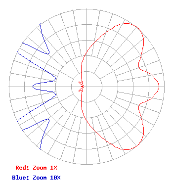 | |||||||||||||||||||||||
| Azimuth | Ratio | Azimuth | Ratio | Azimuth | Ratio | Azimuth | Ratio | |||||||||||||||||
| 0 | 0.432 | 10 | 0.570 | 20 | 0.738 | 30 | 0.931 | |||||||||||||||||
| 40 | 1.000 | 50 | 0.955 | 60 | 0.813 | 70 | 0.717 | |||||||||||||||||
| 80 | 0.846 | 90 | 0.931 | 100 | 0.846 | 110 | 0.717 | |||||||||||||||||
| 120 | 0.813 | 130 | 0.955 | 140 | 1.000 | 150 | 0.931 | |||||||||||||||||
| 160 | 0.738 | 170 | 0.570 | 180 | 0.432 | 190 | 0.316 | |||||||||||||||||
| 200 | 0.202 | 210 | 0.131 | 220 | 0.089 | 230 | 0.065 | |||||||||||||||||
| 240 | 0.116 | 250 | 0.051 | 260 | 0.043 | 270 | 0.069 | |||||||||||||||||
| 280 | 0.043 | 290 | 0.051 | 300 | 0.116 | 310 | 0.065 | |||||||||||||||||
| 320 | 0.089 | 330 | 0.131 | 340 | 0.202 | 350 | 0.316 | |||||||||||||||||
Structure Registration Number 1024624 [ASR Heights Differ from K33GM-D Application] Structure Type: TOWER Registered To: REGION 1 TRANSLATORS ASSOCIATION Structure Address: Us Hwy 6 & Logan Cty Rd 95 Haxtun, CO County Name: Logan County ASR Issued: 04/08/2014 Date Built: 01/01/1997 Site Elevation: 1249.7 m (4100 ft.) Structure Height: 86.9 m (285 ft.) Height Overall: 92.4 m (303 ft.) Overall Height AMSL: 1342.1 m (4403 ft.) FAA Determination: 01/16/1997 FAA Study #: 97-ANM-0014-OE FAA Circular #: 70/7460-1J Paint & Light FAA Chapters: 4, 8, 13 40-38-57.0 N 102-41-00.0 W (NAD 83) 40-38-57.0 N 102-40-58.3 W (Converted to NAD 27) |
323 W 4th Ave Yuma, CO 80759 Phone: 970-630-3854 Applicant | Date: 09/28/2011 Application Certifier REGION 1 TRANSLATOR ASSOCIATION Po Box 284 Wray, CO 80758 Applicant ED LAKE P.o. Box 284 Wray, CO 80758 CHIEF OPERATOR ED LAKE Power Up Electrical Llc | ||||||||||||||||||||||