
FCCInfo.com
A Service of Cavell, Mertz & Associates, Inc.
(855) FCC-INFO
|
|
KMSB from 09/12/1985 KMSB from 08/12/1985 |
Virtual Channel 11 |  |
|
|||||||||||||||
|
|
Repacking Information: No changes Status: License Application Accepted: 06/23/2005 License Expires: 10/01/2022 File Number: BLCDT-20050623ABE Prefix Type: This is a License for a commercial digital TV station FCC Website Links: LMS Facility Details This Application Other KMSB Applications Including Superseded Applications Mailing Address Correspondence for KMSB Correspondence related to application BLCDT-20050623ABE Service Contour - Open Street Map or USGS Map (41 dBu) Service Contour - KML / Google Earth (41 dBu) Public Inspection Files History Cards for KMSB Rabbit Ears Info Search for KMSB Site Location: 32-24-56.0 N 110-42-52.0 W (NAD 83) Site Location: 32-24-55.7 N 110-42-49.7 W (Converted to NAD 27) ERP: 480 kW Polarization: Horizontally polarized HAAT: 1123 m (3684 ft.) Electrical Beam Tilt: 1.2 degrees R/C AGL: 53 m (174 ft.) R/C AMSL: 2659 m (8724 ft.) Site Elevation: 2606 m. (8550 ft.) Height Overall*: 61.5 m (202 ft.) (* As Filed In This Application, may differ from ASR Data, Below.) Directional Antenna - Antenna Make/Model: DIELECTRIC TUA-C3-12/36H-1-R Antenna ID: 64314 Polarization: Horizontally polarized | ||||||||||||||||||
| Antenna Data for Antenna Id: 64314 KMSB DT File: BLCDT-20050623ABE DIELECTRIC - TUA-C3-12/36H-1-R Service: DT Standard Pattern: Y | 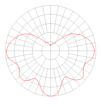 | ||||||||||||||||||
| Azimuth | Ratio | Azimuth | Ratio | Azimuth | Ratio | Azimuth | Ratio | ||||||||||||
| 0 | 0.114 | 10 | 0.130 | 20 | 0.173 | 30 | 0.189 | ||||||||||||
| 40 | 0.342 | 50 | 0.562 | 60 | 0.709 | 70 | 0.832 | ||||||||||||
| 80 | 0.921 | 90 | 0.964 | 100 | 0.935 | 110 | 0.823 | ||||||||||||
| 120 | 0.832 | 130 | 0.920 | 140 | 0.841 | 150 | 0.667 | ||||||||||||
| 160 | 0.737 | 170 | 0.937 | 180 | 1.000 | 190 | 0.926 | ||||||||||||
| 200 | 0.749 | 210 | 0.710 | 220 | 0.860 | 230 | 0.885 | ||||||||||||
| 240 | 0.795 | 250 | 0.817 | 260 | 0.936 | 270 | 0.967 | ||||||||||||
| 280 | 0.910 | 290 | 0.821 | 300 | 0.713 | 310 | 0.551 | ||||||||||||
| 320 | 0.328 | 330 | 0.199 | 340 | 0.193 | 350 | 0.130 | ||||||||||||
Structure Registration Number 1007178 Structure Type: Registered To: Gray Media Group, Inc. Structure Address: Top Of Mount Bigelow 18 Mi Ne Tucson, AZ County Name: Pima County ASR Issued: 02/11/2019 Date Built: 09/01/1961 Site Elevation: 2606 m (8550 ft.) Structure Height: 45.7 m (150 ft.) Height Overall: 61.5 m (202 ft.) Overall Height AMSL: 2667.5 m (8752 ft.) Paint & Light FAA Chapters: 1, 3, 11, 21 32-24-56.0 N 110-42-52.0 W (NAD 83) 32-24-55.7 N 110-42-49.7 W (Converted to NAD 27) |
Tegna Inc. 8350 Broad Street, Suite 2000 Tysons, VA 22102 Phone: 703-873-6606 Limited Liability Company | Date: 06/23/2005 Application Certifier KMSB-TV, INC. 1855 N. 6th Avenue Tucson, AZ 85705 Applicant WALCOTT DENISON III 1855 N. 6th Avenue Tucson, AZ 85705 DIRECTOR OF ENGINEERING JOHN BURGETT Wiley Rein & Fielding Llp 1776 K Street, Nw Washington, DC 20006 | |||||||||||||||||