
FCCInfo.com
A Service of Cavell, Mertz & Associates, Inc.
(855) FCC-INFO
|
|
|
Virtual Channel 2 |  |
|
||||||||||||||||||||||||||||||
|
|
Repacking Information: No changes Status: License Application Accepted: 03/15/2011 License Expires: 10/01/2022 File Number: BLCDT-20110315ABB Prefix Type: This is a License for a commercial digital TV station FCC Website Links: LMS Facility Details This Application Other KTWO-TV Applications Including Superseded Applications Mailing Address Correspondence for KTWO-TV Correspondence related to application BLCDT-20110315ABB Service Contour - Open Street Map or USGS Map (41 dBu) Service Contour - KML / Google Earth (41 dBu) Public Inspection Files History Cards for KTWO-TV Rabbit Ears Info Search for KTWO-TV Site Location: 42-44-26.0 N 106-21-36.0 W (NAD 83) Site Location: 42-44-26.1 N 106-21-33.9 W (Converted to NAD 27) ERP: 52.9 kW Polarization: Horizontally polarized HAAT: 560 m (1837 ft.) Electrical Beam Tilt: 1 degree R/C AGL: 49.9 m (164 ft.) R/C AMSL: 2494.9 m (8185 ft.) Site Elevation: 2445 m. (8022 ft.) Height Overall*: 54.8 m (180 ft.) (* As Filed In This Application, may differ from ASR Data, Below.) Directional Antenna - Antenna Make/Model: Jampro JA/MS16 Antenna ID: 102338 Polarization: Horizontally polarized
| |||||||||||||||||||||||||||||||||
| Antenna Data for Antenna Id: 102338 KTWO-TV DT File: BLCDT-20110315ABB Jampro - JA/MS16 Service: DT Standard Pattern: Y Pattern and Field Values Include a 10° Clockwise Rotation | 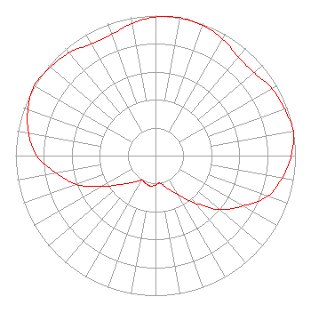 | |||||||||||||||||||||||||||||||||
| Azimuth | Ratio | Azimuth | Ratio | Azimuth | Ratio | Azimuth | Ratio | |||||||||||||||||||||||||||
| 0 | 0.990 | 10 | 1.000 | 20 | 0.990 | 30 | 0.960 | |||||||||||||||||||||||||||
| 40 | 0.920 | 50 | 0.920 | 60 | 0.960 | 70 | 0.980 | |||||||||||||||||||||||||||
| 80 | 1.000 | 90 | 0.970 | 100 | 0.920 | 110 | 0.850 | |||||||||||||||||||||||||||
| 120 | 0.720 | 130 | 0.600 | 140 | 0.440 | 150 | 0.320 | |||||||||||||||||||||||||||
| 160 | 0.250 | 170 | 0.200 | 180 | 0.210 | 190 | 0.220 | |||||||||||||||||||||||||||
| 200 | 0.210 | 210 | 0.200 | 220 | 0.250 | 230 | 0.320 | |||||||||||||||||||||||||||
| 240 | 0.440 | 250 | 0.600 | 260 | 0.720 | 270 | 0.850 | |||||||||||||||||||||||||||
| 280 | 0.920 | 290 | 0.970 | 300 | 1.000 | 310 | 0.980 | |||||||||||||||||||||||||||
| 320 | 0.960 | 330 | 0.920 | 340 | 0.920 | 350 | 0.960 | |||||||||||||||||||||||||||
Structure Registration Number 1008931 [ASR Heights Differ from KTWO-TV Application] Structure Type: GTOWER Registered To: Mark III Media, Inc. Structure Address: Casper Mountain 7.5 Mi Sw Casper, WY County Name: Natrona County ASR Issued: 01/30/2014 Date Built: 01/01/1980 Site Elevation: 2444.5 m (8020 ft.) Structure Height: 54.8 m (180 ft.) Height Overall: 54.8 m (180 ft.) Overall Height AMSL: 2499.3 m (8200 ft.) FAA Determination: 11/23/2009 FAA Study #: 2009-ANM-1918-OE Paint & Light FAA Chapters: NONE PRIOR STUDY 1992-ANM-465-OE 42-44-26.0 N 106-21-36.0 W (NAD 83) 42-44-26.1 N 106-21-33.9 W (Converted to NAD 27) |
8620 Cold Springs Road Raleigh, NC 27615 Phone: 919-414-9288 Limited Liability Company | Date: 03/15/2011 Application Certifier SILVERTON BROADCASTING COMPANY, LLC 1856 Skyview Dr. Casper, WY 82601 Applicant B.W. ST. CLAIR 2355 Ranch Drive Westminster, CO 80234 ENGINEERING CONSULTANT HOWARD LIBERMAN Drinker Biddle & Reath Llp 1500 K Street, Nw Ste 1100 Washington, DC 20006 | ||||||||||||||||||||||||||||||||
| ||||||||||||||||||||||||||||||||||