
FCCInfo.com
A Service of Cavell, Mertz & Associates, Inc.
(855) FCC-INFO
|
|
K40KC-D from 05/06/1992 |
|
|
||||||||||||||||
|
|
Status: License (Licensed And Silent) Application Accepted: 07/09/2008 License Expires: 06/01/2022 File Number: BLDTL-20080709AKE Prefix Type: This is BLDTL FCC Website Links: LMS Facility Details This Application Other K40KC-D Applications Including Superseded Applications Mailing Address Correspondence for K40KC-D Correspondence related to application BLDTL-20080709AKE Service Contour - Open Street Map or USGS Map (51 dBu) Service Contour - KML / Google Earth (51 dBu) Rabbit Ears Info Search for K40KC-D Site Location: 36-06-56.0 N 96-01-03.0 W (NAD 83) Site Location: 36-06-55.7 N 96-01-02.0 W (Converted to NAD 27) ERP: 1.5 kW R/C AGL: 60 m (197 ft.) R/C AMSL: 335 m (1099 ft.) Emission Mask: Stringent Site Elevation: 275 m. (902 ft.) Height Overall*: 98 m (322 ft.) (* As Filed In This Application, may differ from ASR Data, Below.) Directional Antenna - Antenna Make/Model: Jampro JA/LS-OM-16 Antenna ID: 19581 | ||||||||||||||||||
| Antenna Data for Antenna Id: 19581 K40KC-D LD File: BLDTL-20080709AKE Jampro - JA/LS-OM-16 Service: LD Standard Pattern: Y Pattern and Field Values Include a 90° Clockwise Rotation | 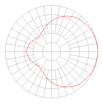 | ||||||||||||||||||
| Azimuth | Ratio | Azimuth | Ratio | Azimuth | Ratio | Azimuth | Ratio | ||||||||||||
| 0 | 0.660 | 10 | 0.740 | 20 | 0.810 | 30 | 0.870 | ||||||||||||
| 40 | 0.920 | 45 | 0.930 | 50 | 0.940 | 60 | 0.970 | ||||||||||||
| 70 | 0.980 | 80 | 0.990 | 90 | 1.000 | 100 | 0.990 | ||||||||||||
| 110 | 0.980 | 120 | 0.970 | 130 | 0.940 | 135 | 0.930 | ||||||||||||
| 140 | 0.920 | 150 | 0.870 | 160 | 0.810 | 170 | 0.740 | ||||||||||||
| 180 | 0.660 | 190 | 0.580 | 200 | 0.500 | 210 | 0.450 | ||||||||||||
| 220 | 0.420 | 225 | 0.430 | 230 | 0.440 | 240 | 0.460 | ||||||||||||
| 250 | 0.500 | 260 | 0.520 | 270 | 0.550 | 280 | 0.520 | ||||||||||||
| 290 | 0.500 | 300 | 0.460 | 310 | 0.440 | 315 | 0.430 | ||||||||||||
| 320 | 0.420 | 330 | 0.450 | 340 | 0.500 | 350 | 0.580 | ||||||||||||
Structure Registration Number 1040118 Structure Type: GTOWER Registered To: American Towers LLC Structure Address: 3301 S. 26th Street Tulsa, OK County Name: Tulsa County ASR Issued: 05/28/2020 Date Built: 01/26/1988 Site Elevation: 275 m (902 ft.) Structure Height: 91.4 m (300 ft.) Height Overall: 98.1 m (322 ft.) Overall Height AMSL: 373.1 m (1224 ft.) FAA Determination: 08/03/2010 FAA Study #: 2010-ASW-3602-OE FAA Circular #: 70/7460-1K Paint & Light FAA Chapters: 4, 8, 12 OM&L to remain the same as prior study = A MED-DUAL SYSTEM 36-06-56.0 N 96-01-03.0 W (NAD 83) 36-06-55.7 N 96-01-02.0 W (Converted to NAD 27) |
Hurst, TX 76054 Phone: 214-770-7770 Corporation | Date: 07/09/2008 Application Certifier THREE ANGELS BROADCASTING NETWORK, INC. P O Box 220 West Frankfort, IL 62896-0220 Applicant DANIEL N. PEEK Po Box 220 West Frankfort, IL 62896-0220 ENGINEER MOSES PRIMO 3abn | |||||||||||||||||