
FCCInfo.com
A Service of Cavell, Mertz & Associates, Inc.
(855) FCC-INFO
|
|
WACN-LD from 02/19/1996 WACN-LD from 05/10/1990 |
|
|
||||||||||||||||
|
|
Status: License Application Accepted: 06/09/2006 License Expires: 12/01/2020 File Number: BLTTL-20060609AAA Prefix Type: This is a license for a UHF LPTV station FCC Website Links: LMS Facility Details This Application Other WACN-LD Applications Including Superseded Applications Mailing Address Correspondence for WACN-LD Correspondence related to application BLTTL-20060609AAA Service Contour - Open Street Map or USGS Map (74 dBu) Service Contour - KML / Google Earth (74 dBu) Rabbit Ears Info Search for WACN-LD Site Location: 35-40-29.0 N 78-31-39.0 W (NAD 83) Site Location: 35-40-28.4 N 78-31-40.0 W (Converted to NAD 27) ERP: 27.65 kW R/C AGL: 300 m (984 ft.) R/C AMSL: 410 m (1345 ft.) Site Elevation: 110 m. (361 ft.) Height Overall*: 606 m (1988 ft.) (* As Filed In This Application, may differ from ASR Data, Below.) Directional Antenna - Antenna Make/Model: Propagation System Inc PSILP16CRA Antenna ID: 20393 | ||||||||||||||||||
| Antenna Data for Antenna Id: 20393 WACN-LD TX File: BLTTL-20060609AAA Propagation System Inc - PSILP16CRA Service: TX Standard Pattern: Y Pattern and Field Values Include a 300° Clockwise Rotation | 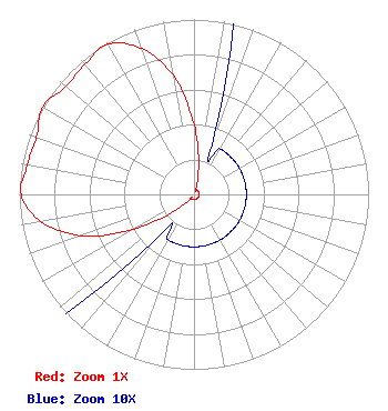 | ||||||||||||||||||
| Azimuth | Ratio | Azimuth | Ratio | Azimuth | Ratio | Azimuth | Ratio | ||||||||||||
| 0 | 0.400 | 10 | 0.150 | 20 | 0.030 | 30 | 0.030 | ||||||||||||
| 40 | 0.030 | 50 | 0.030 | 60 | 0.030 | 70 | 0.030 | ||||||||||||
| 80 | 0.030 | 90 | 0.030 | 100 | 0.030 | 110 | 0.030 | ||||||||||||
| 120 | 0.030 | 130 | 0.030 | 140 | 0.030 | 150 | 0.030 | ||||||||||||
| 160 | 0.030 | 170 | 0.030 | 180 | 0.030 | 190 | 0.030 | ||||||||||||
| 200 | 0.030 | 210 | 0.030 | 220 | 0.030 | 230 | 0.150 | ||||||||||||
| 240 | 0.400 | 250 | 0.690 | 260 | 0.890 | 270 | 0.990 | ||||||||||||
| 280 | 0.970 | 290 | 0.960 | 300 | 1.000 | 310 | 0.960 | ||||||||||||
| 320 | 0.970 | 330 | 0.990 | 340 | 0.890 | 350 | 0.690 | ||||||||||||
Structure Registration Number 1027322 Structure Type: LTOWER Registered To: CBC REAL ESTATE COMPANY, INC. Structure Address: 5033 Tv Tower Rd Garner, NC County Name: Wake County ASR Issued: 07/08/2020 Date Built: 03/23/2000 Site Elevation: 109.7 m (360 ft.) Structure Height: 606.2 m (1989 ft.) Height Overall: 606.2 m (1989 ft.) Overall Height AMSL: 715.9 m (2349 ft.) FAA Determination: 05/19/2020 FAA Study #: 2019-ASO-24710-OE FAA Circular #: 70/7460-1J Paint & Light FAA Chapters: 4, 7, 13 OM&L to remain the same as prior study = 24-HR HI-STROBES 35-40-29.0 N 78-31-39.0 W (NAD 83) 35-40-28.4 N 78-31-40.0 W (Converted to NAD 27) |
3901 Highway 121, South Bedford, TX 76021 Phone: 817-571-1229 Not-for-Profit | Date: 06/09/2006 Application Certifier WORD OF GOD FELLOWSHIP, INC. 3901 Highway 121 South Bedford, TX 76021 Applicant RICHARD C GOETZ 135 N Country Club Drive Hendersonville, TN 37075 BROADCAST CONSULTANT ROBERT L. OLENDER Koerner & Olender, P.c. | |||||||||||||||||