
FCCInfo.com
A Service of Cavell, Mertz & Associates, Inc.
(855) FCC-INFO
|
|
K08OU-D from 10/31/1989 |
|
|
||||||||||||||||
|
|
Status: License Application Accepted: 11/17/2008 License Expires: 02/01/2023 File Number: BLDVL-20081117ACQ Prefix Type: This is BLDVL FCC Website Links: LMS Facility Details This Application Other K08OU-D Applications Including Superseded Applications Mailing Address Correspondence for K08OU-D Correspondence related to application BLDVL-20081117ACQ Service Contour - Open Street Map or USGS Map (48 dBu) Service Contour - KML / Google Earth (48 dBu) Rabbit Ears Info Search for K08OU-D Site Location: 47-36-56.3 N 122-18-30.4 W (NAD 83) Site Location: 47-36-56.9 N 122-18-25.9 W (Converted to NAD 27) ERP: 0.25 kW R/C AGL: 122 m (400 ft.) R/C AMSL: 247 m (810 ft.) Emission Mask: Simple Site Elevation: 125 m. (410 ft.) Height Overall*: 207.9 m (682 ft.) (* As Filed In This Application, may differ from ASR Data, Below.) Directional Antenna - Antenna Make/Model: Scala HDCA-5 SEATTLE Antenna ID: 85315 | ||||||||||||||||||
| Antenna Data for Antenna Id: 85315 K08OU-D LD File: BLDVL-20081117ACQ Scala - HDCA-5 SEATTLE Service: LD Standard Pattern: Y | 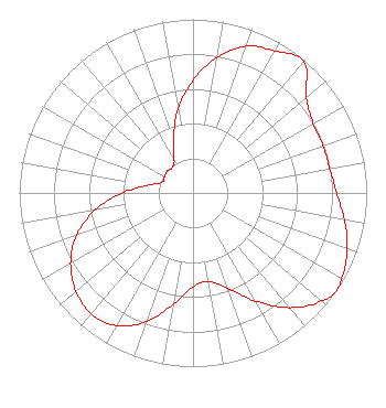 | ||||||||||||||||||
| Azimuth | Ratio | Azimuth | Ratio | Azimuth | Ratio | Azimuth | Ratio | ||||||||||||
| 0 | 0.649 | 10 | 0.792 | 20 | 0.901 | 30 | 0.945 | ||||||||||||
| 40 | 0.990 | 50 | 0.851 | 60 | 0.799 | 70 | 0.797 | ||||||||||||
| 80 | 0.799 | 90 | 0.827 | 100 | 0.885 | 110 | 0.945 | ||||||||||||
| 120 | 0.987 | 125 | 0.999 | 130 | 0.965 | 140 | 0.862 | ||||||||||||
| 150 | 0.719 | 160 | 0.584 | 170 | 0.517 | 180 | 0.541 | ||||||||||||
| 190 | 0.649 | 200 | 0.789 | 210 | 0.883 | 220 | 0.910 | ||||||||||||
| 230 | 0.880 | 240 | 0.814 | 250 | 0.713 | 260 | 0.574 | ||||||||||||
| 270 | 0.409 | 280 | 0.256 | 290 | 0.186 | 300 | 0.190 | ||||||||||||
| 310 | 0.196 | 320 | 0.188 | 330 | 0.216 | 340 | 0.330 | ||||||||||||
| 350 | 0.492 | ||||||||||||||||||
Structure Registration Number 1226015 Structure Type: TOWER Registered To: Fox Television Stations, LLC Structure Address: 1620 18th Avenue Seattle, WA County Name: King County ASR Issued: 11/05/2020 Date Built: 07/10/2001 Site Elevation: 125 m (410 ft.) Structure Height: 173.7 m (570 ft.) Height Overall: 207.9 m (682 ft.) Overall Height AMSL: 332.9 m (1092 ft.) FAA Determination: 01/19/2000 FAA Study #: 98-ANM-1099-OE FAA Circular #: 70/7460-1J Paint & Light FAA Chapters: 4, 7, 13 Removed expiration date from determination. Scenario 1./jjs/case#635066 47-36-56.3 N 122-18-30.4 W (NAD 83) 47-36-56.9 N 122-18-25.9 W (Converted to NAD 27) |
Hurst, TX 76054 Phone: 214-770-7770 Corporation | Date: 11/17/2008 Application Certifier THREE ANGELS BROADCASTING NETWORK, INC. P O Box 220 West Frankfort, IL 62896-0220 Applicant DANIEL N. PEEK Po Box 220 West Frankfort, IL 62896-0220 ENGINEER MOSES PRIMO 3abn | |||||||||||||||||