
FCCInfo.com
A Service of Cavell, Mertz & Associates, Inc.
(855) FCC-INFO
|
|
KWHE from 02/15/1985 KWHE from 11/08/1982 |
Virtual Channel 14 |  |
|
|||||||||||||||
|
|
Repacking Information: No changes Status: License Application Accepted: 06/28/2006 License Expires: 02/01/2023 File Number: BLCDT-20060628AAN Prefix Type: This is a License for a commercial digital TV station FCC Website Links: LMS Facility Details This Application Other KWHE Applications Including Superseded Applications Mailing Address Correspondence for KWHE Correspondence related to application BLCDT-20060628AAN Service Contour - Open Street Map or USGS Map (41 dBu) Service Contour - KML / Google Earth (41 dBu) Public Inspection Files History Cards for KWHE Rabbit Ears Info Search for KWHE Site Location: 21-18-38.0 N 157-51-33.0 W (NAD 83) Site Location: 21-18-49.4 N 157-51-42.9 W (Converted to NAD 27) ERP: 20.1 kW Polarization: Horizontally polarized HAAT: 5 m (16 ft.) Electrical Beam Tilt: 0.25 degrees R/C AGL: 133 m (436 ft.) R/C AMSL: 140 m (459 ft.) Site Elevation: 7 m. (23 ft.) Height Overall*: 139 m (456 ft.) (* As Filed In This Application, may differ from ASR Data, Below.) Directional Antenna - Antenna Make/Model: R.F. Systems RD8H-1736L1L00 Antenna ID: 72786 Polarization: Horizontally polarized | ||||||||||||||||||
| Antenna Data for Antenna Id: 72786 KWHE DT File: BLCDT-20060628AAN R.F. Systems - RD8H-1736L1L00 Service: DT Standard Pattern: Y Pattern and Field Values Include a 35° Clockwise Rotation | 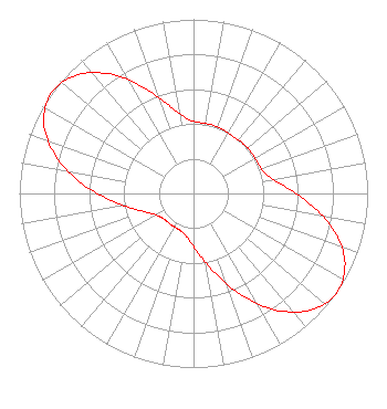 | ||||||||||||||||||
| Azimuth | Ratio | Azimuth | Ratio | Azimuth | Ratio | Azimuth | Ratio | ||||||||||||
| 5 | 0.408 | 15 | 0.408 | 25 | 0.404 | 35 | 0.398 | ||||||||||||
| 45 | 0.404 | 55 | 0.408 | 65 | 0.408 | 75 | 0.431 | ||||||||||||
| 85 | 0.517 | 95 | 0.669 | 105 | 0.838 | 115 | 0.960 | ||||||||||||
| 125 | 1.000 | 135 | 0.949 | 145 | 0.817 | 155 | 0.641 | ||||||||||||
| 165 | 0.473 | 175 | 0.348 | 185 | 0.271 | 195 | 0.233 | ||||||||||||
| 205 | 0.222 | 215 | 0.222 | 225 | 0.222 | 235 | 0.233 | ||||||||||||
| 245 | 0.271 | 255 | 0.348 | 265 | 0.473 | 275 | 0.641 | ||||||||||||
| 285 | 0.817 | 295 | 0.949 | 305 | 1.000 | 315 | 0.960 | ||||||||||||
| 325 | 0.838 | 335 | 0.669 | 345 | 0.517 | 355 | 0.431 | ||||||||||||
Structure Registration Number 1007317 Structure Type: B Registered To: LESEA BROADCASTING OF HAWAII, INC. Structure Address: 1188 Bishop St Honolulu, HI County Name: Honolulu County ASR Issued: 05/24/2007 Date Built: 01/01/1988 Site Elevation: 7 m (23 ft.) Structure Height: 117.5 m (385 ft.) Height Overall: 139 m (456 ft.) Overall Height AMSL: 146 m (479 ft.) FAA Study #: N/A Paint & Light FAA Chapters: 3, 21 21-18-38.0 N 157-51-33.0 W (NAD 83) 21-18-49.4 N 157-51-42.9 W (Converted to NAD 27) |
61300 Ironwood Road South Bend, IN 46614 Phone: 574-291-8200 Not-for-Profit | Date: 06/28/2006 Application Certifier LESEA BROADCASTING CORPORATION 61300 S. Ironwood Road South Bend, IN 46614 Applicant MARTIN W. HYLTON 61300 Ironwood Road South Bend, IN 46614 STAFF ENGINEER JOSEPH C. CHAUTIN, III Hardy, Carey, Chautin & Balkin, L.l.p. 110 Veterans Blvd Suite 300 Metairie, LA 70005 | |||||||||||||||||