
FCCInfo.com
A Service of Cavell, Mertz & Associates, Inc.
(855) FCC-INFO
|
|
KXFX-CD from 05/02/2012 KXFX-CD from 03/02/2005 KXFX-CD from 05/19/1999 KXFX-CD from 02/18/1997 |
Virtual Channel 21 |
|
||||||||||||||||
|
|
Repacking Information: No changes Status: License Application Accepted: 02/02/2015 License Expires: 08/01/2014 File Number: BLDTA-20150202ADU Prefix Type: This is BLDTA FCC Website Links: LMS Facility Details This Application Other KXFX-CD Applications Including Superseded Applications Mailing Address Correspondence for KXFX-CD Correspondence related to application BLDTA-20150202ADU Service Contour - Open Street Map or USGS Map (51 dBu) Service Contour - KML / Google Earth (51 dBu) Public Inspection Files Rabbit Ears Info Search for KXFX-CD Site Location: 25-57-50.5 N 97-31-13.3 W (NAD 83) Site Location: 25-57-49.2 N 97-31-12.4 W (Converted to NAD 27) ERP: 0.5 kW R/C AGL: 142 m (466 ft.) R/C AMSL: 149.3 m (490 ft.) Emission Mask: Full Service Site Elevation: 7.3 m. (24 ft.) Height Overall*: 149.3 m (490 ft.) (* As Filed In This Application, may differ from ASR Data, Below.) Directional Antenna - Antenna Make/Model: Andrew ALP32L3-HSM Antenna ID: 16834 | ||||||||||||||||||
| Antenna Data for Antenna Id: 16834 KXFX-CD DC File: BLDTA-20150202ADU Andrew - ALP32L3-HSM Service: DC Standard Pattern: Y Pattern and Field Values Include a 170° Clockwise Rotation | 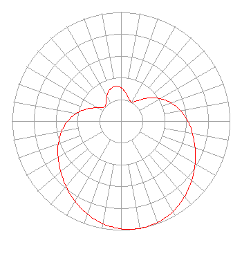 | ||||||||||||||||||
| Azimuth | Ratio | Azimuth | Ratio | Azimuth | Ratio | Azimuth | Ratio | ||||||||||||
| 0 | 0.306 | 10 | 0.262 | 20 | 0.214 | 30 | 0.200 | ||||||||||||
| 40 | 0.247 | 50 | 0.328 | 60 | 0.413 | 70 | 0.489 | ||||||||||||
| 80 | 0.554 | 90 | 0.612 | 100 | 0.667 | 110 | 0.723 | ||||||||||||
| 120 | 0.785 | 130 | 0.848 | 140 | 0.907 | 150 | 0.956 | ||||||||||||
| 160 | 0.989 | 170 | 1.000 | 180 | 0.989 | 190 | 0.956 | ||||||||||||
| 200 | 0.907 | 210 | 0.848 | 220 | 0.785 | 230 | 0.723 | ||||||||||||
| 240 | 0.667 | 250 | 0.612 | 260 | 0.554 | 270 | 0.489 | ||||||||||||
| 280 | 0.413 | 290 | 0.328 | 300 | 0.247 | 310 | 0.200 | ||||||||||||
| 320 | 0.214 | 330 | 0.262 | 340 | 0.306 | 350 | 0.322 | ||||||||||||
Structure Registration Number 1050340 Structure Type: GTOWER Registered To: American Towers LLC Structure Address: 3523 Mcallen Rd (brownsville 2b #004547) Brownsville, TX County Name: Cameron County ASR Issued: 02/01/2024 Date Built: 07/01/1996 Site Elevation: 7.3 m (24 ft.) Structure Height: 146.3 m (480 ft.) Height Overall: 149.4 m (490 ft.) Overall Height AMSL: 156.7 m (514 ft.) FAA Determination: 02/14/2023 FAA Study #: 2022-ASW-16466-OE FAA Circular #: 70/7460-1H Paint & Light FAA Chapters: 4, 6, 13 OM&L to remain the same as prior study = 24-HR MED-STROBES 25-57-49.2 N 97-31-13.2 W (NAD 83) 25-57-47.9 N 97-31-12.3 W (Converted to NAD 27) |
2425 Olympic Blvd Ste 6000 W Santa Monica, CA 90404 Phone: 310-447-3870 Limited Liability Company | Date: 02/02/2015 Application Certifier ENTRAVISION HOLDINGS, LLC Suite 6000 West 2425 Olympic Boulevard Santa Monica, CA 90404 Applicant MANUEL CAVAZOS III 801 N. Jackson Road Mcallen, TX 78501 SVP DIRECTOR OF ENGINEERING BARRY A. FRIEDMAN Thompson Hine Llp | |||||||||||||||||