
FCCInfo.com
A Service of Cavell, Mertz & Associates, Inc.
(855) FCC-INFO
|
|
|
Virtual Channel 14 |
|
||||||||||||||||||||||
|
|
Repacking Information: No changes Status: Construction Permit Application Accepted: 04/20/2010 KTBO-TV CP Expires: 06/01/2022 File Number: BXPCDT-20100420AHY Prefix Type: This is a construction permit for a commercial digital TV station auxiliary antenna FCC Website Links: LMS Facility Details This Application Other KTBO-TV Applications Including Superseded Applications Mailing Address Correspondence for KTBO-TV Correspondence related to application BXPCDT-20100420AHY Service Contour - Open Street Map or USGS Map (41 dBu) Service Contour - KML / Google Earth (41 dBu) Public Inspection Files History Cards for KTBO-TV Rabbit Ears Info Search for KTBO-TV Site Location: 35-34-35.0 N 97-29-10.0 W (NAD 83) Site Location: 35-34-34.8 N 97-29-08.9 W (Converted to NAD 27) ERP: 7.9 kW Polarization: Horizontally polarized HAAT: 159.4 m (523 ft.) Electrical Beam Tilt: 1.25 degrees R/C AGL: 152.4 m (500 ft.) R/C AMSL: 509.4 m (1671 ft.) Site Elevation: 357 m. (1171 ft.) Height Overall*: 360 m (1181 ft.) (* As Filed In This Application, may differ from ASR Data, Below.) Directional Antenna - Antenna Make/Model: Andrew AL12M-15-PL Antenna ID: 99027 Polarization: Horizontally polarized
| ||||||||||||||||||||||||
| Antenna Data for Antenna Id: 99027 KTBO-TV DX File: BXPCDT-20100420AHY Andrew - AL12M-15-PL Service: DX Standard Pattern: Y | 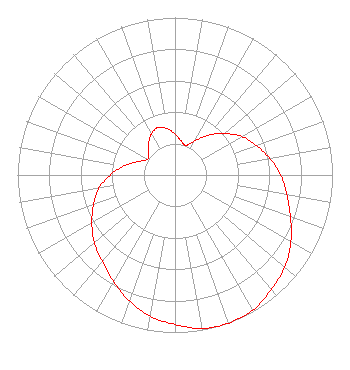 | ||||||||||||||||||||||||
| Azimuth | Ratio | Azimuth | Ratio | Azimuth | Ratio | Azimuth | Ratio | ||||||||||||||||||
| 0 | 0.260 | 10 | 0.220 | 20 | 0.200 | 30 | 0.250 | ||||||||||||||||||
| 40 | 0.330 | 50 | 0.410 | 60 | 0.490 | 70 | 0.550 | ||||||||||||||||||
| 80 | 0.610 | 90 | 0.670 | 100 | 0.720 | 110 | 0.780 | ||||||||||||||||||
| 120 | 0.850 | 130 | 0.910 | 140 | 0.950 | 150 | 0.990 | ||||||||||||||||||
| 160 | 1.000 | 170 | 0.990 | 180 | 0.950 | 190 | 0.910 | ||||||||||||||||||
| 200 | 0.850 | 210 | 0.780 | 220 | 0.720 | 230 | 0.670 | ||||||||||||||||||
| 240 | 0.610 | 250 | 0.550 | 260 | 0.490 | 270 | 0.410 | ||||||||||||||||||
| 280 | 0.330 | 290 | 0.250 | 300 | 0.200 | 310 | 0.220 | ||||||||||||||||||
| 320 | 0.260 | 330 | 0.300 | 340 | 0.320 | 350 | 0.300 | ||||||||||||||||||
Structure Registration Number 1064281 Structure Type: GTOWER Registered To: Trilogy Genesis, Inc. DBA TRINITY BROADCASTING OF OKLAHOMA CITY, INC. Structure Address: 1528 E. Hefner Road Oklahoma City, OK County Name: Oklahoma County ASR Issued: 09/17/2021 Date Built: 09/08/2021 Site Elevation: 357 m (1171 ft.) Structure Height: 343 m (1125 ft.) Height Overall: 360 m (1181 ft.) Overall Height AMSL: 717 m (2352 ft.) FAA Determination: 07/01/2021 FAA Study #: 2021-ASW-7713-OE FAA Circular #: 70/7460-1M Paint & Light FAA Chapters: 4, 9, 15 PRIOR STUDY 2018-ASW-11456-OE 35-34-35.0 N 97-29-10.5 W (NAD 83) 35-34-34.8 N 97-29-09.4 W (Converted to NAD 27) |
13600 Heritage Parkway Suite 200 Fort Worth, TX 76177 Phone: 855-826-2255 Not-for-Profit | Date: 04/20/2010 Application Certifier TRINITY BROADCASTING OF OKLAHOMA CITY,INC. 1600 E. Hefner Road Oklahoma City, OK 73131 Applicant KYLE FISHER 2237 Tacketts Mill Drive Suite A Lakeridge, VA 22192 CONSULTING ENGINEER COLBY M. MAY, ESQ. Colby M. May, Esq., P.c. 205 Third Street, S.e. Washington, DC 20003 | |||||||||||||||||||||||
| |||||||||||||||||||||||||