
FCCInfo.com
A Service of Cavell, Mertz & Associates, Inc.
(855) FCC-INFO
|
|
|
Virtual Channel 14 |  |
|
|||||||||||||||||||||
|
|
Repacking Information: No changes Status: License Application Accepted: 07/10/2013 License Expires: 10/01/2021 File Number: BLEDT-20130710ABN Prefix Type: This is a license for a noncommercial educational digital TV station FCC Website Links: LMS Facility Details This Application Other WCMU-TV Applications Including Superseded Applications Mailing Address Correspondence for WCMU-TV Correspondence related to application BLEDT-20130710ABN Service Contour - Open Street Map or USGS Map (41 dBu) Service Contour - KML / Google Earth (41 dBu) Public Inspection Files History Cards for WCMU-TV Rabbit Ears Info Search for WCMU-TV Site Location: 43-45-05.1 N 85-12-46.2 W (NAD 83) Site Location: 43-45-05.0 N 85-12-46.1 W (Converted to NAD 27) ERP: 450 kW Polarization: Horizontally polarized HAAT: 298 m (978 ft.) Electrical Beam Tilt: 0.8 degrees R/C AGL: 287 m (942 ft.) R/C AMSL: 617.1 m (2025 ft.) Site Elevation: 330.1 m. (1083 ft.) Height Overall*: 293.8 m (964 ft.) (* As Filed In This Application, may differ from ASR Data, Below.) Directional Antenna - Antenna Make/Model: DIELECTRIC TUF-C4-12/48H-1-T Antenna ID: 114084 Polarization: Horizontally polarized | ||||||||||||||||||||||||
| Antenna Data for Antenna Id: 114084 WCMU-TV DT File: BLEDT-20130710ABN DIELECTRIC - TUF-C4-12/48H-1-T Service: DT Standard Pattern: Y | 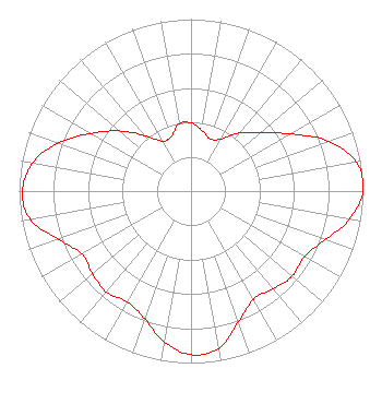 | ||||||||||||||||||||||||
| Azimuth | Ratio | Azimuth | Ratio | Azimuth | Ratio | Azimuth | Ratio | ||||||||||||||||||
| 0 | 0.396 | 10 | 0.359 | 20 | 0.323 | 30 | 0.349 | ||||||||||||||||||
| 40 | 0.440 | 50 | 0.529 | 60 | 0.665 | 70 | 0.848 | ||||||||||||||||||
| 80 | 0.976 | 90 | 1.000 | 100 | 0.936 | 110 | 0.830 | ||||||||||||||||||
| 120 | 0.762 | 130 | 0.770 | 140 | 0.743 | 150 | 0.726 | ||||||||||||||||||
| 160 | 0.808 | 170 | 0.930 | 180 | 0.952 | 190 | 0.891 | ||||||||||||||||||
| 200 | 0.790 | 210 | 0.743 | 220 | 0.766 | 230 | 0.748 | ||||||||||||||||||
| 240 | 0.731 | 250 | 0.820 | 260 | 0.950 | 270 | 0.980 | ||||||||||||||||||
| 280 | 0.936 | 290 | 0.820 | 300 | 0.672 | 310 | 0.544 | ||||||||||||||||||
| 320 | 0.422 | 330 | 0.335 | 340 | 0.337 | 350 | 0.398 | ||||||||||||||||||
Structure Registration Number 1229622 Structure Type: GTOWER Registered To: CMU Public Broadcasting Structure Address: Three Miles West Of Barryton, Michigan On County Road 65 Barryton, MI County Name: Mecosta County ASR Issued: 10/04/2016 Date Built: 09/15/2003 Site Elevation: 330.1 m (1083 ft.) Structure Height: 292.9 m (961 ft.) Height Overall: 293.8 m (964 ft.) Overall Height AMSL: 623.9 m (2047 ft.) FAA Determination: 10/23/2012 FAA Study #: 2012-AGL-6979-OE FAA Circular #: 70/7460-1K Paint & Light FAA Chapters: 4, 7, 12 Continue As Is OM&L = PAINT/RED LIGHTS 43-45-05.1 N 85-12-46.2 W (NAD 83) 43-45-05.0 N 85-12-46.1 W (Converted to NAD 27) |
1999 East Campus Drive Mount Pleasant, MI 48859 Phone: 989-774-3105 Government Entity | Date: 07/10/2013 Application Certifier CENTRAL MICHIGAN UNIVERSITY Public Broadcasting 1999 East Campus Drive Mt Pleasant, MI 48859 Applicant WAYNE HENDERSON 1999 E. Campus Drive Mt. Pleasant, MI 48859 DIRECTOR OF TECHNICAL SERVICES BARRY S. PERSH Dow Lohnes Pllc 1200 New Hampshire Ave., N.w. Suite 800 Washington, DC 20036 | |||||||||||||||||||||||
| |||||||||||||||||||||||||