
FCCInfo.com
A Service of Cavell, Mertz & Associates, Inc.
(855) FCC-INFO
|
|
K34AI-D from 03/07/1988 |
|
|
|||||||||||||||||||||
|
|
Status: License Application Accepted: 08/21/2009 License Expires: 02/01/2023 File Number: BLDTT-20090821ABT Prefix Type: This is BLDTT FCC Website Links: LMS Facility Details This Application Other K34AI-D Applications Including Superseded Applications Mailing Address Correspondence for K34AI-D Correspondence related to application BLDTT-20090821ABT Service Contour - Open Street Map or USGS Map (51 dBu) Service Contour - KML / Google Earth (51 dBu) Rabbit Ears Info Search for K34AI-D Site Location: 43-52-24.4 N 121-30-15.1 W (NAD 83) Site Location: 43-52-25.0 N 121-30-11.0 W (Converted to NAD 27) ERP: 0.72 kW R/C AGL: 15 m (49 ft.) R/C AMSL: 1516 m (4974 ft.) Emission Mask: Simple Site Elevation: 1501 m. (4925 ft.) Height Overall*: 16.9 m (55 ft.) (* As Filed In This Application, may differ from ASR Data, Below.) Directional Antenna - Antenna Make/Model: Scala PR450U Antenna ID: 65078
| |||||||||||||||||||||||
| Antenna Data for Antenna Id: 65078 K34AI-D LD File: BLDTT-20090821ABT Scala - PR450U Service: LD Standard Pattern: Y Pattern and Field Values Include a 180° Clockwise Rotation | 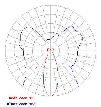 | |||||||||||||||||||||||
| Azimuth | Ratio | Azimuth | Ratio | Azimuth | Ratio | Azimuth | Ratio | |||||||||||||||||
| 0 | 0.025 | 10 | 0.030 | 20 | 0.040 | 30 | 0.040 | |||||||||||||||||
| 40 | 0.070 | 50 | 0.070 | 60 | 0.075 | 70 | 0.075 | |||||||||||||||||
| 80 | 0.065 | 90 | 0.060 | 100 | 0.060 | 110 | 0.060 | |||||||||||||||||
| 120 | 0.060 | 130 | 0.060 | 140 | 0.090 | 150 | 0.180 | |||||||||||||||||
| 160 | 0.460 | 170 | 0.815 | 180 | 1.000 | 190 | 0.800 | |||||||||||||||||
| 200 | 0.400 | 210 | 0.150 | 220 | 0.090 | 230 | 0.070 | |||||||||||||||||
| 240 | 0.065 | 250 | 0.060 | 260 | 0.060 | 270 | 0.060 | |||||||||||||||||
| 280 | 0.070 | 290 | 0.070 | 300 | 0.075 | 310 | 0.075 | |||||||||||||||||
| 320 | 0.065 | 330 | 0.025 | 340 | 0.025 | 350 | 0.025 | |||||||||||||||||
Structure Registration Number 1249718 Structure Type: POLE Registered To: NPG of Oregon, Inc. Structure Address: Spring River Butte Sunriver, OR County Name: Deschutes County ASR Issued: 05/11/2015 Date Built: 01/01/1980 Site Elevation: 1501.1 m (4925 ft.) Structure Height: 16.8 m (55 ft.) Height Overall: 16.8 m (55 ft.) Overall Height AMSL: 1517.9 m (4980 ft.) FAA Determination: 08/09/2005 FAA Study #: 2005-ANM-1376-OE Paint & Light FAA Chapters: NONE 43-52-24.4 N 121-30-15.1 W (NAD 83) 43-52-25.0 N 121-30-11.0 W (Converted to NAD 27) |
525 Junction Road Madison, WI 53717 Phone: 608-664-4000 Limited Liability Company | Date: 08/21/2009 Application Certifier RURAL OREGON WIRELESS TELEVISION, INC. 7140 Sw Macadam Ave. Portland, OR 97219-3099 Applicant WALT WARD 315 High Point Crossing Huffman, TX 77336 CONSULTING ENGINEER JOHN M. BURGETT, ESQ. Wiley Rein Llp | ||||||||||||||||||||||