
FCCInfo.com
A Service of Cavell, Mertz & Associates, Inc.
(855) FCC-INFO
|
|
|
|
|
||||||||||||||||
|
|
Status: License (Licensed And Silent) Application Accepted: 04/05/2000 License Expires: 10/01/2021 File Number: BLTTL-20000328ACP Prefix Type: This is a license for a UHF LPTV station FCC Website Links: LMS Facility Details This Application Other W48CL Applications Including Superseded Applications Mailing Address Correspondence for W48CL Correspondence related to application BLTTL-20000328ACP Service Contour - Open Street Map or USGS Map (74 dBu) Service Contour - KML / Google Earth (74 dBu) Rabbit Ears Info Search for W48CL Site Location: 43-00-59.3 N 85-44-24.2 W (NAD 83) Site Location: 43-00-59.2 N 85-44-24.1 W (Converted to NAD 27) ERP: 16.1 kW Polarization: Horizontally polarized R/C AGL: 94 m (308 ft.) R/C AMSL: 329 m (1079 ft.) Calculated Site Elevation: 235 m. (771 ft.) Height Overall*: 128 m (420 ft.) (* As Filed In This Application, may differ from ASR Data, Below.) Directional Antenna - Antenna Make/Model: Antenna Concepts Inc. ACS8C Antenna ID: 17792 Polarization: Horizontally polarized | ||||||||||||||||||
| Antenna Data for Antenna Id: 17792 W48CL TX File: BLTTL-20000328ACP Antenna Concepts Inc. - ACS8C Service: TX Standard Pattern: Y Pattern and Field Values Include a 125° Clockwise Rotation | 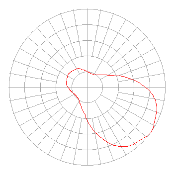 | ||||||||||||||||||
| Azimuth | Ratio | Azimuth | Ratio | Azimuth | Ratio | Azimuth | Ratio | ||||||||||||
| 5 | 0.190 | 15 | 0.180 | 25 | 0.180 | 35 | 0.190 | ||||||||||||
| 45 | 0.220 | 55 | 0.270 | 65 | 0.350 | 75 | 0.500 | ||||||||||||
| 85 | 0.660 | 95 | 0.820 | 105 | 0.920 | 115 | 0.960 | ||||||||||||
| 125 | 1.000 | 135 | 0.960 | 145 | 0.920 | 155 | 0.820 | ||||||||||||
| 165 | 0.660 | 175 | 0.500 | 185 | 0.350 | 195 | 0.270 | ||||||||||||
| 205 | 0.220 | 215 | 0.190 | 225 | 0.180 | 235 | 0.180 | ||||||||||||
| 245 | 0.190 | 255 | 0.210 | 265 | 0.230 | 275 | 0.260 | ||||||||||||
| 285 | 0.270 | 295 | 0.280 | 305 | 0.290 | 315 | 0.280 | ||||||||||||
| 325 | 0.270 | 335 | 0.260 | 345 | 0.230 | 355 | 0.210 | ||||||||||||
Structure Registration Number 1007106 [ASR Heights Differ from W48CL Application] Structure Type: GTOWER Registered To: SBA Towers II LLC Structure Address: 2853 Three Mile Road Nw (mi10597-a) Walker, MI County Name: Kent County ASR Issued: 05/30/2023 Date Built: 01/01/1991 Site Elevation: 238 m (781 ft.) Structure Height: 120.7 m (396 ft.) Height Overall: 125.9 m (413 ft.) Overall Height AMSL: 363.9 m (1194 ft.) FAA Determination: 12/08/2022 FAA Study #: 2022-AGL-1815-OE FAA Circular #: 70/7460-1K Paint & Light FAA Chapters: 4, 8, 12 OM&L to remain the same as prior study = A MED-DUAL SYSTEM 43-00-59.3 N 85-44-24.2 W (NAD 83) 43-00-59.2 N 85-44-24.1 W (Converted to NAD 27) |
Hurst, TX 76054 Phone: 214-770-7770 Corporation | Date: 04/05/2000 Application Certifier THREE ANGELS BROADCASTING NETWORK, INC. P.o. Box 220 West Frankfort, IL 62896 Applicant DANNY SHELTON ???? | |||||||||||||||||