
FCCInfo.com
A Service of Cavell, Mertz & Associates, Inc.
(855) FCC-INFO
|
|
WFXL from 12/08/1981 WFXL from 03/13/1981 |
Virtual Channel 31 |  |
|
|||||||||||||||
|
|
Repacking Information: No changes Status: License Application Accepted: 07/25/2007 License Expires: 04/01/2021 File Number: BLCDT-20070725AFF Prefix Type: This is a License for a commercial digital TV station FCC Website Links: LMS Facility Details This Application Other WFXL Applications Including Superseded Applications Mailing Address Correspondence for WFXL Correspondence related to application BLCDT-20070725AFF Service Contour - Open Street Map or USGS Map (36 dBu) Service Contour - KML / Google Earth (36 dBu) Public Inspection Files History Cards for WFXL Rabbit Ears Info Search for WFXL Site Location: 31-19-53.0 N 83-51-43.0 W (NAD 83) Site Location: 31-19-52.3 N 83-51-43.4 W (Converted to NAD 27) ERP: 60 kW Polarization: Horizontally polarized HAAT: 253 m (830 ft.) Electrical Beam Tilt: 1 degree R/C AGL: 245.4 m (805 ft.) R/C AMSL: 355.7 m (1167 ft.) Site Elevation: 110.3 m. (362 ft.) Height Overall*: 304.8 m (1000 ft.) (* As Filed In This Application, may differ from ASR Data, Below.) Directional Antenna - Antenna Make/Model: DIELECTRIC THV-12A12-R C170 Antenna ID: 75986 Polarization: Horizontally polarized | ||||||||||||||||||
| Antenna Data for Antenna Id: 75986 WFXL DT File: BLCDT-20070725AFF DIELECTRIC - THV-12A12-R C170 Service: DT Standard Pattern: Y | 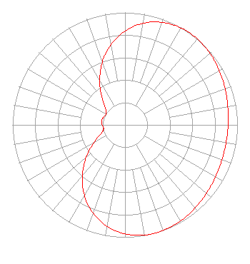 | ||||||||||||||||||
| Azimuth | Ratio | Azimuth | Ratio | Azimuth | Ratio | Azimuth | Ratio | ||||||||||||
| 0 | 0.834 | 10 | 0.918 | 20 | 0.971 | 30 | 0.996 | ||||||||||||
| 35 | 1.000 | 40 | 0.999 | 50 | 0.987 | 60 | 0.967 | ||||||||||||
| 70 | 0.946 | 80 | 0.928 | 90 | 0.917 | 100 | 0.912 | ||||||||||||
| 110 | 0.917 | 120 | 0.928 | 130 | 0.946 | 140 | 0.967 | ||||||||||||
| 150 | 0.987 | 160 | 0.999 | 165 | 1.000 | 170 | 0.996 | ||||||||||||
| 180 | 0.971 | 190 | 0.918 | 200 | 0.834 | 210 | 0.723 | ||||||||||||
| 220 | 0.591 | 230 | 0.450 | 240 | 0.320 | 250 | 0.226 | ||||||||||||
| 260 | 0.193 | 270 | 0.203 | 280 | 0.212 | 290 | 0.203 | ||||||||||||
| 300 | 0.193 | 310 | 0.226 | 320 | 0.320 | 330 | 0.450 | ||||||||||||
| 340 | 0.591 | 350 | 0.723 | ||||||||||||||||
Structure Registration Number 1255221 Structure Type: Registered To: Albany Tower, LLC Structure Address: N. Of Rt. 270, 2.5 Mi. E. Doerun, GA County Name: Colquitt County ASR Issued: 11/08/2013 Date Built: 08/01/2007 Site Elevation: 110.3 m (362 ft.) Structure Height: 304.8 m (1000 ft.) Height Overall: 304.8 m (1000 ft.) Overall Height AMSL: 415.1 m (1362 ft.) FAA Determination: 08/22/2006 FAA Study #: 2006-ASO-4186-OE Paint & Light FAA Chapters: 1, 3, 6, 15, 21 Continue As Is OM&L = PAINT/RED LIGHTS 31-19-53.0 N 83-51-43.0 W (NAD 83) 31-19-52.3 N 83-51-43.4 W (Converted to NAD 27) |
Pillsbury Winthrop Shaw Pittman Llp 1200 Seventeenth Street, Nw Washington, DC 20036 Phone: 202-663-8195 Limited Liability Company | Date: 07/25/2007 Application Certifier BARRINGTON ALBANY LICENSE LLC 2500 W. Higgins Road Suite 155 Hoffman Estates, IL 60169 Applicant WILLIAM H. FITZ, ESQ. Covington & Burling Llp 1201 Pennsylvania Avenue, N.w. Washington, DC 20004-2401 KENNETH CLUBB 2500 W. Higgins Road Suite 155 Hoffman Estates, IL 60169 CHIEF ENGINEER | |||||||||||||||||
| |||||||||||||||||||