
FCCInfo.com
A Service of Cavell, Mertz & Associates, Inc.
(855) FCC-INFO
|
|
KINC from 11/10/1993 |
Virtual Channel 15 |
|
||||||||||||||||||||||||||||
|
|
Repacking Information: No changes Status: License Application Accepted: 06/30/2006 License Expires: 10/01/2022 File Number: BLCDT-20060630ACH Prefix Type: This is a License for a commercial digital TV station FCC Website Links: LMS Facility Details This Application Other KINC Applications Including Superseded Applications Mailing Address Correspondence for KINC Correspondence related to application BLCDT-20060630ACH Service Contour - Open Street Map or USGS Map (41 dBu) Service Contour - KML / Google Earth (41 dBu) Public Inspection Files Rabbit Ears Info Search for KINC Site Location: 35-56-46.0 N 115-02-37.0 W (NAD 83) Site Location: 35-56-46.1 N 115-02-34.0 W (Converted to NAD 27) ERP: 1000 kW Polarization: Horizontally polarized HAAT: 570.5 m (1872 ft.) Electrical Beam Tilt: 0.75 degrees R/C AGL: 38 m (125 ft.) R/C AMSL: 1354.7 m (4445 ft.) Site Elevation: 1316.7 m. (4320 ft.) Height Overall*: 83.5 m (274 ft.) (* As Filed In This Application, may differ from ASR Data, Below.) Directional Antenna - Antenna Make/Model: DIELECTRIC TFU-22DSC-R-4S250 DC Antenna ID: 78119 Polarization: Horizontally polarized
| ||||||||||||||||||||||||||||||
| Antenna Data for Antenna Id: 78119 KINC DT File: BLCDT-20060630ACH DIELECTRIC - TFU-22DSC-R-4S250 DC Service: DT Standard Pattern: Y | 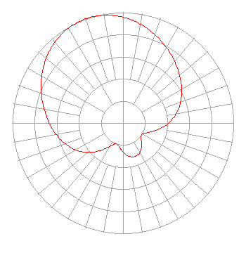 | ||||||||||||||||||||||||||||||
| Azimuth | Ratio | Azimuth | Ratio | Azimuth | Ratio | Azimuth | Ratio | ||||||||||||||||||||||||
| 0 | 0.956 | 10 | 0.907 | 20 | 0.848 | 30 | 0.785 | ||||||||||||||||||||||||
| 40 | 0.723 | 50 | 0.667 | 60 | 0.612 | 70 | 0.554 | ||||||||||||||||||||||||
| 80 | 0.489 | 90 | 0.413 | 100 | 0.328 | 110 | 0.247 | ||||||||||||||||||||||||
| 120 | 0.200 | 130 | 0.214 | 140 | 0.262 | 150 | 0.306 | ||||||||||||||||||||||||
| 160 | 0.322 | 170 | 0.306 | 180 | 0.262 | 190 | 0.214 | ||||||||||||||||||||||||
| 200 | 0.200 | 210 | 0.247 | 220 | 0.328 | 230 | 0.413 | ||||||||||||||||||||||||
| 240 | 0.489 | 250 | 0.554 | 260 | 0.612 | 270 | 0.667 | ||||||||||||||||||||||||
| 280 | 0.723 | 290 | 0.785 | 300 | 0.848 | 310 | 0.907 | ||||||||||||||||||||||||
| 320 | 0.956 | 330 | 0.989 | 340 | 1.000 | 350 | 0.989 | ||||||||||||||||||||||||
Structure Registration Number 1020486 Structure Type: TOWER Registered To: KUPN Licensee, LLC Structure Address: 7-a Black Mountain Rd Black Mtn Arden Site Henderson, NV County Name: Clark County ASR Issued: 01/11/2017 Date Built: 03/01/1989 Site Elevation: 1316.7 m (4320 ft.) Structure Height: 81.4 m (267 ft.) Height Overall: 83.5 m (274 ft.) Overall Height AMSL: 1400.2 m (4594 ft.) FAA Determination: 04/18/1997 FAA Study #: 97-AWP-0697-OE Paint & Light FAA Chapters: NONE ADJACENT TO EXISTING STRUCTURES WHICH ARE MARKED & LIGHTED. LCS 35-56-46.0 N 115-02-37.0 W (NAD 83) 35-56-46.1 N 115-02-34.0 W (Converted to NAD 27) |
2425 Olympic Blvd Ste 6000 W Santa Monica, CA 90404 Phone: 310-447-3870 Limited Liability Company | Date: 06/30/2006 Application Certifier ENTRAVISION HOLDINGS, LLC Suite 6000 West 2425 Olympic Boulevard Santa Monica, CA 90404 Applicant MANUEL CAVAZOS III 801 N. Jackson Mcallen, TX 78501 DIRECTOR OF ENGINEERING BARRY A. FRIEDMAN Thompson Hine Llp Suite 800 1920 N Street, N.w. Washington, DC 20036 | |||||||||||||||||||||||||||||
| |||||||||||||||||||||||||||||||