
FCCInfo.com
A Service of Cavell, Mertz & Associates, Inc.
(855) FCC-INFO
|
|
|
|
|
|||||||||||||||||
|
|
Status: License Application Accepted: 10/03/2011 License Expires: 06/01/2022 File Number: BLDTT-20111003ANW Prefix Type: This is BLDTT FCC Website Links: LMS Facility Details This Application Other K18IZ-D Applications Including Superseded Applications Mailing Address Correspondence for K18IZ-D Correspondence related to application BLDTT-20111003ANW Service Contour - Open Street Map or USGS Map (51 dBu) Service Contour - KML / Google Earth (51 dBu) Rabbit Ears Info Search for K18IZ-D Site Location: 34-12-05.0 N 98-43-46.0 W (NAD 83) Site Location: 34-12-04.7 N 98-43-44.8 W (Converted to NAD 27) ERP: 15 kW Electrical Beam Tilt: 0.7 degrees R/C AGL: 315.4 m (1035 ft.) R/C AMSL: 653.1 m (2143 ft.) Emission Mask: Simple Site Elevation: 337.7 m. (1108 ft.) Height Overall*: 327 m (1073 ft.) (* As Filed In This Application, may differ from ASR Data, Below.) Directional Antenna - Antenna Make/Model: Harris TWS-30C Antenna ID: 101123
| |||||||||||||||||||
| Antenna Data for Antenna Id: 101123 K18IZ-D LD File: BLDTT-20111003ANW Harris - TWS-30C Service: LD Standard Pattern: Y | 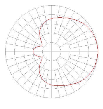 | |||||||||||||||||||
| Azimuth | Ratio | Azimuth | Ratio | Azimuth | Ratio | Azimuth | Ratio | |||||||||||||
| 0 | 0.710 | 10 | 0.740 | 20 | 0.775 | 30 | 0.820 | |||||||||||||
| 40 | 0.870 | 50 | 0.920 | 60 | 0.955 | 70 | 0.980 | |||||||||||||
| 80 | 0.990 | 90 | 1.000 | 100 | 0.990 | 110 | 0.980 | |||||||||||||
| 120 | 0.955 | 130 | 0.920 | 140 | 0.875 | 150 | 0.825 | |||||||||||||
| 160 | 0.780 | 170 | 0.745 | 180 | 0.720 | 190 | 0.675 | |||||||||||||
| 200 | 0.615 | 210 | 0.515 | 220 | 0.395 | 230 | 0.275 | |||||||||||||
| 240 | 0.240 | 250 | 0.300 | 260 | 0.370 | 270 | 0.400 | |||||||||||||
| 280 | 0.375 | 290 | 0.310 | 300 | 0.245 | 310 | 0.270 | |||||||||||||
| 320 | 0.375 | 330 | 0.505 | 340 | 0.600 | 350 | 0.670 | |||||||||||||
Structure Registration Number 1050255 Structure Type: GTOWER Registered To: Mission Broadcasting, Inc. Structure Address: 0.16 Mi Se Of N2380 Rd And E1940 Rd Intersection. Grandfield, OK County Name: Tillman County ASR Issued: 09/26/2023 Date Built: 09/26/2023 Site Elevation: 337.7 m (1108 ft.) Structure Height: 304.9 m (1000 ft.) Height Overall: 327.1 m (1073 ft.) Overall Height AMSL: 664.8 m (2181 ft.) FAA Determination: 01/12/2023 FAA Study #: 2022-ASW-19532-OE FAA Circular #: 70/7460-1G Paint & Light FAA Chapters: 3, 4, 5, 9 OM&L to remain the same as prior study = PAINT/RED LIGHTS 34-12-05.8 N 98-43-45.9 W (NAD 83) 34-12-05.5 N 98-43-44.7 W (Converted to NAD 27) |
7403 North Kelley Avenue Oklahoma City, OK 73113 Phone: 405-848-8501 Government Entity | Date: 10/03/2011 Application Certifier OKLAHOMA EDUCATIONAL TELEVISION AUTHORITY 7403 North Kelley Avenue Oklahoma City, OK 73113 Applicant DONALD G. EVERIST Cohen, Dippell And Everist, P.c. 1420 N Street, Nw Suite One Washington, DC 20005 CONSULTING ENGINEER BARRY S. PERSH Dow Lohnes Pllc | ||||||||||||||||||