
FCCInfo.com
A Service of Cavell, Mertz & Associates, Inc.
(855) FCC-INFO
|
|
KRIN from 01/24/1980 |
Virtual Channel 32 |
|
||||||||||||||||
|
|
Status: Application Application Accepted: 06/04/2012 License Expires: 02/01/2022 File Number: BDRTEDT-20120604AFO Prefix Type: This is BDRTEDT FCC Website Links: LMS Facility Details This Application Other KRIN Applications Including Superseded Applications Mailing Address Correspondence for KRIN Correspondence related to application BDRTEDT-20120604AFO Service Contour - Open Street Map or USGS Map (51 dBu) Service Contour - KML / Google Earth (51 dBu) History Cards for KRIN Rabbit Ears Info Search for KRIN Site Location: 42-31-09.0 N 90-37-11.0 W (NAD 83) Site Location: 42-31-09.0 N 90-37-10.5 W (Converted to NAD 27) ERP: 2 kW Electrical Beam Tilt: 1 degree R/C AGL: 152.4 m (500 ft.) R/C AMSL: 414.5 m (1360 ft.) Emission Mask: Stringent Site Elevation: 262.1 m. (860 ft.) Height Overall*: 255.1 m (837 ft.) (* As Filed In This Application, may differ from ASR Data, Below.) Directional Antenna - Antenna Make/Model: DIELECTRIC TLP12-M Antenna ID: 109538 | ||||||||||||||||||
| Antenna Data for Antenna Id: 109538 KRIN LD File: BDRTEDT-20120604AFO DIELECTRIC - TLP12-M Service: LD Standard Pattern: Y Pattern and Field Values Include a 260° Clockwise Rotation | 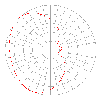 | ||||||||||||||||||
| Azimuth | Ratio | Azimuth | Ratio | Azimuth | Ratio | Azimuth | Ratio | ||||||||||||
| 0 | 0.684 | 10 | 0.593 | 20 | 0.497 | 30 | 0.392 | ||||||||||||
| 40 | 0.280 | 50 | 0.197 | 60 | 0.184 | 70 | 0.226 | ||||||||||||
| 80 | 0.257 | 90 | 0.227 | 100 | 0.183 | 110 | 0.194 | ||||||||||||
| 120 | 0.278 | 130 | 0.393 | 140 | 0.502 | 150 | 0.599 | ||||||||||||
| 160 | 0.688 | 170 | 0.778 | 180 | 0.873 | 190 | 0.951 | ||||||||||||
| 200 | 0.993 | 210 | 1.000 | 220 | 0.976 | 230 | 0.944 | ||||||||||||
| 240 | 0.918 | 250 | 0.901 | 260 | 0.895 | 270 | 0.908 | ||||||||||||
| 280 | 0.921 | 290 | 0.942 | 300 | 0.974 | 310 | 1.000 | ||||||||||||
| 320 | 0.985 | 330 | 0.940 | 340 | 0.865 | 350 | 0.775 | ||||||||||||
Structure Registration Number 1055265 Structure Type: TOWER Registered To: Second Generation Realty of Iowa Structure Address: 0.7 Mi North Of Illinois State Line, 0.7 Mi West Of Highway 35 Kieler, WI County Name: Grant County ASR Issued: 12/26/2007 Date Built: 01/01/1976 Site Elevation: 262.1 m (860 ft.) Structure Height: 240.5 m (789 ft.) Height Overall: 255.1 m (837 ft.) Overall Height AMSL: 517.2 m (1697 ft.) FAA Determination: 08/06/1998 FAA Study #: 98-AGL-3319-OE FAA Circular #: 70/7460-1J Paint & Light FAA Chapters: 3, 4, 5, 13 OM&L TO REMAIN RED LIGHTS/PAINT. 42-31-09.0 N 90-37-11.0 W (NAD 83) 42-31-09.0 N 90-37-10.5 W (Converted to NAD 27) |
6450 Corporate Drive Johnston, IA 50131 Phone: 515-725-9700 Government Entity | Date: 06/04/2012 Application Certifier IOWA PUBLIC BROADCASTING BOARD P.o. Box 6450 Johnston, IA 50131-6450 Applicant GREGORY L BEST 9223 N. Manning Avenue Kansas City, MO 64157 CONSULTING ENGINEER MARGARET L. MILLER Dow Lohnes Pllc 1200 New Hampshire Ave. Nw Suite 800 Washington, DC 20036 | |||||||||||||||||