
FCCInfo.com
A Service of Cavell, Mertz & Associates, Inc.
(855) FCC-INFO
|
|
WLOV-TV from 01/22/1981 |
Virtual Channel 27 |  |
|
||||||||||||||||||||||||
|
|
Repacking Information: No changes Status: License Application Accepted: 04/05/2007 License Expires: 06/01/2021 File Number: BLCDT-20070405ABC Prefix Type: This is a License for a commercial digital TV station FCC Website Links: LMS Facility Details This Application Other WLOV-TV Applications Including Superseded Applications Mailing Address Correspondence for WLOV-TV Correspondence related to application BLCDT-20070405ABC Service Contour - Open Street Map or USGS Map (41 dBu) Service Contour - KML / Google Earth (41 dBu) Public Inspection Files Rabbit Ears Info Search for WLOV-TV Site Location: 33-47-40.0 N 89-05-16.0 W (NAD 83) Site Location: 33-47-39.6 N 89-05-15.8 W (Converted to NAD 27) ERP: 390 kW Polarization: Horizontally polarized HAAT: 508.9 m (1670 ft.) Electrical Beam Tilt: 0.5 degrees R/C AGL: 434.9 m (1427 ft.) R/C AMSL: 611.6 m (2007 ft.) Site Elevation: 176.7 m. (580 ft.) Height Overall*: 485.5 m (1593 ft.) (* As Filed In This Application, may differ from ASR Data, Below.) Directional Antenna - Antenna Make/Model: Jampro JSH-24/16-SHC Antenna ID: 78413 Polarization: Horizontally polarized | |||||||||||||||||||||||||||
| Antenna Data for Antenna Id: 78413 WLOV-TV DT File: BLCDT-20070405ABC Jampro - JSH-24/16-SHC Service: DT Standard Pattern: Y | 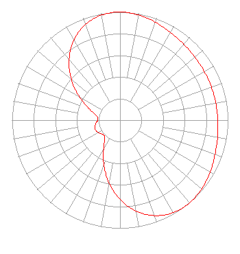 | |||||||||||||||||||||||||||
| Azimuth | Ratio | Azimuth | Ratio | Azimuth | Ratio | Azimuth | Ratio | |||||||||||||||||||||
| 0 | 1.000 | 10 | 0.988 | 20 | 0.963 | 30 | 0.936 | |||||||||||||||||||||
| 40 | 0.917 | 50 | 0.905 | 60 | 0.900 | 70 | 0.899 | |||||||||||||||||||||
| 80 | 0.900 | 90 | 0.905 | 100 | 0.917 | 110 | 0.936 | |||||||||||||||||||||
| 120 | 0.963 | 130 | 0.988 | 140 | 1.000 | 150 | 0.987 | |||||||||||||||||||||
| 160 | 0.940 | 170 | 0.854 | 180 | 0.733 | 190 | 0.588 | |||||||||||||||||||||
| 200 | 0.437 | 210 | 0.302 | 220 | 0.218 | 230 | 0.207 | |||||||||||||||||||||
| 240 | 0.232 | 250 | 0.245 | 260 | 0.232 | 270 | 0.207 | |||||||||||||||||||||
| 280 | 0.218 | 290 | 0.302 | 300 | 0.437 | 310 | 0.588 | |||||||||||||||||||||
| 320 | 0.733 | 330 | 0.854 | 340 | 0.940 | 350 | 0.987 | |||||||||||||||||||||
Structure Registration Number 1040183 [ASR Heights Differ from WLOV-TV Application] Structure Type: GTOWER Registered To: Mississippi TV, LLC Structure Address: On Fire Tower Road, 2.1 Miles Nw Woodland, MS County Name: Chickasaw County ASR Issued: 02/20/2015 Date Built: 08/06/2013 Site Elevation: 176.7 m (580 ft.) Structure Height: 457.8 m (1502 ft.) Height Overall: 475.4 m (1560 ft.) Overall Height AMSL: 652.1 m (2139 ft.) FAA Determination: 07/23/2013 FAA Study #: 2013-ASO-6030-OE Paint & Light FAA Chapters: 3, 4, 5, 12 PRIOR STUDY 2008-ASO-2105-OE CHAPTERS 3,4,5,12 (1K) ADD SPECIAL CONDTION FOR LIGHTING DEVIATION 33-47-40.0 N 89-05-16.0 W (NAD 83) 33-47-39.6 N 89-05-15.8 W (Converted to NAD 27) |
2750 Luberon Lane Cumming, GA 30041 Phone: 678-777-8659 Limited Liability Company | Date: 04/05/2007 Application Certifier LINGARD BROADCASTING CORPORATION P.o. Box 1732 Tupelo, MS 38802 Applicant DANE E. ERICKSEN, P.E. Hammett & Edison, Inc. Box 280068 San Francisco, CA 94128 CONSULTING ENGINEER ROBERT E. LEVINE Law Offices Of Robert E. Levine | ||||||||||||||||||||||||||
| ||||||||||||||||||||||||||||