
FCCInfo.com
A Service of Cavell, Mertz & Associates, Inc.
(855) FCC-INFO
|
|
KTPX-TV from 01/13/1998 KTPX-TV from 06/09/1987 |
Virtual Channel 44 |  |
|
||||||||||||||||||
|
|
Repacking Information: No changes Status: License Application Accepted: 05/10/2002 License Expires: 06/01/2022 File Number: BLCDT-20020510AAQ Prefix Type: This is a License for a commercial digital TV station FCC Website Links: LMS Facility Details This Application Other KTPX-TV Applications Including Superseded Applications Mailing Address Correspondence for KTPX-TV Correspondence related to application BLCDT-20020510AAQ Service Contour - Open Street Map or USGS Map (41 dBu) Service Contour - KML / Google Earth (41 dBu) Public Inspection Files Rabbit Ears Info Search for KTPX-TV Site Location: 35-50-02.0 N 96-07-29.0 W (NAD 83) Site Location: 35-50-01.7 N 96-07-28.0 W (Converted to NAD 27) ERP: 1000 kW Polarization: Horizontally polarized HAAT: 219 m (719 ft.) Electrical Beam Tilt: 0.75 degrees R/C AGL: 168 m (551 ft.) R/C AMSL: 452 m (1483 ft.) Site Elevation: 284 m. (932 ft.) Height Overall*: 261 m (856 ft.) (* As Filed In This Application, may differ from ASR Data, Below.) Directional Antenna - Antenna Make/Model: DIELECTRIC TFU-18DSC S190 Antenna ID: 19049 Polarization: Horizontally polarized | |||||||||||||||||||||
| Antenna Data for Antenna Id: 19049 KTPX-TV DT File: BLCDT-20020510AAQ DIELECTRIC - TFU-18DSC S190 Service: DT Standard Pattern: Y | 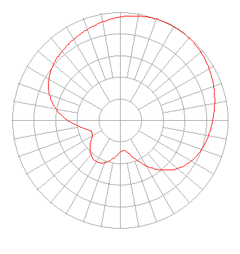 | |||||||||||||||||||||
| Azimuth | Ratio | Azimuth | Ratio | Azimuth | Ratio | Azimuth | Ratio | |||||||||||||||
| 0 | 0.953 | 10 | 0.978 | 20 | 0.994 | 30 | 1.000 | |||||||||||||||
| 40 | 0.994 | 50 | 0.978 | 60 | 0.953 | 70 | 0.922 | |||||||||||||||
| 80 | 0.890 | 90 | 0.860 | 100 | 0.832 | 110 | 0.802 | |||||||||||||||
| 120 | 0.760 | 130 | 0.696 | 140 | 0.603 | 150 | 0.487 | |||||||||||||||
| 160 | 0.368 | 170 | 0.290 | 180 | 0.297 | 190 | 0.361 | |||||||||||||||
| 200 | 0.419 | 210 | 0.442 | 220 | 0.419 | 230 | 0.361 | |||||||||||||||
| 240 | 0.297 | 250 | 0.290 | 260 | 0.368 | 270 | 0.487 | |||||||||||||||
| 280 | 0.603 | 290 | 0.696 | 300 | 0.760 | 310 | 0.802 | |||||||||||||||
| 320 | 0.832 | 330 | 0.860 | 340 | 0.890 | 350 | 0.922 | |||||||||||||||
Structure Registration Number 1009564 [ASR Heights Differ from KTPX-TV Application] Structure Type: GTOWER Registered To: Cowskin Broadcasting, LLC Structure Address: 4.83 Km W Of Hwy Alt 6.76 Km Sw Mounds, OK County Name: Okmulgee County ASR Issued: 10/28/2020 Date Built: 01/01/1986 Site Elevation: 283 m (928 ft.) Structure Height: 261 m (856 ft.) Height Overall: 261 m (856 ft.) Overall Height AMSL: 544 m (1785 ft.) FAA Determination: 09/24/1985 FAA Study #: 85-ASW-1232-OE FAA Circular #: Paint & Light FAA Chapters: 1, 3, 6, 15, 21 35-50-01.7 N 96-07-29.0 W (NAD 83) 35-50-01.4 N 96-07-28.0 W (Converted to NAD 27) |
312 Walnut Street 28th Floor Cincinnati, OH 45202 Phone: 513-977-3000 Limited Liability Company | Date: 05/10/2002 Application Certifier PAXSON TULSA LICENSE, INC. 601 Clearwater Park Road West Palm Beach, FL 33401-6233 Applicant PAUL TITCHENAL 1130 4th St. N. Suite 180 St. Petersburg, FL 33716 DIRECTOR OF BROADCAST DEVELOPMENT SCOTT S. PATRICK, ESQ. Dow, Lohnes & Albertson, Pllc 1200 New Hampshire Ave, Nw Suite 800 Washington, DC 20036 | ||||||||||||||||||||
| ||||||||||||||||||||||