
FCCInfo.com
A Service of Cavell, Mertz & Associates, Inc.
(855) FCC-INFO
|
|
|
|
|
||||||||||||||||
|
|
Status: License Application Accepted: 11/21/2008 License Expires: 06/01/2022 File Number: BLDTV-20081121AKA Prefix Type: This is BLDTV FCC Website Links: LMS Facility Details This Application Other K06JC-D Applications Including Superseded Applications Mailing Address Correspondence for K06JC-D Correspondence related to application BLDTV-20081121AKA Service Contour - Open Street Map or USGS Map (43 dBu) Service Contour - KML / Google Earth (43 dBu) Rabbit Ears Info Search for K06JC-D Site Location: 42-48-47.0 N 103-00-24.0 W (NAD 83) Site Location: 42-48-47.1 N 103-00-22.3 W (Converted to NAD 27) ERP: 0.066 kW R/C AGL: 67 m (220 ft.) R/C AMSL: 1153 m (3783 ft.) Emission Mask: Simple Site Elevation: 1086 m. (3563 ft.) Height Overall*: 92.4 m (303 ft.) (* As Filed In This Application, may differ from ASR Data, Below.) Directional Antenna - Antenna Make/Model: Scala CA-4/CL-26 Antenna ID: 75864
| ||||||||||||||||||
| Antenna Data for Antenna Id: 75864 K06JC-D LD File: BLDTV-20081121AKA Scala - CA-4/CL-26 Service: LD Standard Pattern: Y Pattern and Field Values Include a 10° Clockwise Rotation | 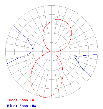 | ||||||||||||||||||
| Azimuth | Ratio | Azimuth | Ratio | Azimuth | Ratio | Azimuth | Ratio | ||||||||||||
| 0 | 0.654 | 10 | 0.703 | 20 | 0.714 | 30 | 0.696 | ||||||||||||
| 40 | 0.648 | 50 | 0.557 | 60 | 0.462 | 70 | 0.347 | ||||||||||||
| 80 | 0.239 | 90 | 0.130 | 100 | 0.057 | 110 | 0.060 | ||||||||||||
| 120 | 0.082 | 130 | 0.168 | 140 | 0.332 | 150 | 0.487 | ||||||||||||
| 160 | 0.672 | 170 | 0.840 | 180 | 0.947 | 190 | 1.000 | ||||||||||||
| 200 | 0.951 | 210 | 0.855 | 220 | 0.691 | 230 | 0.518 | ||||||||||||
| 240 | 0.347 | 250 | 0.154 | 260 | 0.064 | 270 | 0.042 | ||||||||||||
| 280 | 0.042 | 290 | 0.049 | 300 | 0.069 | 310 | 0.144 | ||||||||||||
| 320 | 0.245 | 330 | 0.369 | 340 | 0.494 | 350 | 0.581 | ||||||||||||
Structure Registration Number 1029928 Structure Type: TOWER Registered To: NEBRASKA EDUCATIONAL TELECOMMUNICATION COMMISSION Structure Address: .5 Mi Sw Chadron, NE County Name: Dawes County ASR Issued: 11/03/1997 Date Built: 03/07/1989 Site Elevation: 1086 m (3563 ft.) Structure Height: 92.4 m (303 ft.) Height Overall: 92.4 m (303 ft.) Overall Height AMSL: 1178.4 m (3866 ft.) FAA Determination: 10/20/1997 FAA Study #: 97-ACE-1261-OE FAA Circular #: 70/7460-1J Paint & Light FAA Chapters: 3, 4, 5, 13 42-48-47.0 N 103-00-24.0 W (NAD 83) 42-48-47.1 N 103-00-22.3 W (Converted to NAD 27) |
1800 N. 33rd Street Lincoln, NE 68503 Phone: 402-472-9333 Government Entity | Date: 11/21/2008 Application Certifier NEBRASKA EDUCATIONAL TELECOMMUNICATIONS COMMISSION 1800 N. 33rd Street Lincoln, NE 68503 Applicant ROGER BOOK 1800 N 33rd Street Lincoln, NE 68503 EMPLOYEE BARRY PERSH Dow Lohnes Pllc | |||||||||||||||||