
FCCInfo.com
A Service of Cavell, Mertz & Associates, Inc.
(855) FCC-INFO
|
|
KNIN-TV from 04/13/1992 KNIN-TV from 03/08/1991 |
Virtual Channel 9 |  |
|
|||||||||||||||
|
|
Repacking Information: No changes Status: License Application Accepted: 10/07/2011 License Expires: 10/01/2022 File Number: BLCDT-20111007AEB Prefix Type: This is a License for a commercial digital TV station FCC Website Links: LMS Facility Details This Application Other KNIN-TV Applications Including Superseded Applications Mailing Address Correspondence for KNIN-TV Correspondence related to application BLCDT-20111007AEB Service Contour - Open Street Map or USGS Map (36 dBu) Service Contour - KML / Google Earth (36 dBu) Public Inspection Files Rabbit Ears Info Search for KNIN-TV Site Location: 43-45-18.0 N 116-05-55.0 W (NAD 83) Site Location: 43-45-18.4 N 116-05-51.6 W (Converted to NAD 27) ERP: 25 kW Polarization: Horizontally polarized HAAT: 818 m (2684 ft.) Electrical Beam Tilt: 0.5 degrees R/C AGL: 54 m (177 ft.) R/C AMSL: 2199 m (7215 ft.) Site Elevation: 2145 m. (7037 ft.) Height Overall*: 79.2 m (260 ft.) (* As Filed In This Application, may differ from ASR Data, Below.) Directional Antenna - Antenna Make/Model: DIELECTRIC THB-C2-2H/4HD-1-R Antenna ID: 105403 Polarization: Horizontally polarized | ||||||||||||||||||
| Antenna Data for Antenna Id: 105403 KNIN-TV DT File: BLCDT-20111007AEB DIELECTRIC - THB-C2-2H/4HD-1-R Service: DT Standard Pattern: Y | 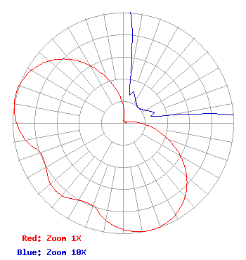 | ||||||||||||||||||
| Azimuth | Ratio | Azimuth | Ratio | Azimuth | Ratio | Azimuth | Ratio | ||||||||||||
| 0 | 0.161 | 10 | 0.039 | 20 | 0.029 | 30 | 0.023 | ||||||||||||
| 40 | 0.020 | 50 | 0.020 | 60 | 0.023 | 70 | 0.029 | ||||||||||||
| 80 | 0.039 | 90 | 0.161 | 100 | 0.285 | 110 | 0.434 | ||||||||||||
| 120 | 0.601 | 130 | 0.751 | 140 | 0.870 | 150 | 0.953 | ||||||||||||
| 160 | 0.995 | 165 | 1.000 | 170 | 0.996 | 180 | 0.961 | ||||||||||||
| 190 | 0.893 | 200 | 0.794 | 210 | 0.804 | 220 | 0.858 | ||||||||||||
| 230 | 0.858 | 240 | 0.804 | 250 | 0.794 | 260 | 0.893 | ||||||||||||
| 270 | 0.961 | 280 | 0.996 | 285 | 1.000 | 290 | 0.995 | ||||||||||||
| 300 | 0.953 | 310 | 0.870 | 320 | 0.751 | 330 | 0.601 | ||||||||||||
| 340 | 0.434 | 350 | 0.285 | ||||||||||||||||
Structure Registration Number 1053967 [ASR Heights Differ from KNIN-TV Application] Structure Type: TOWER Registered To: SUTRO CORPORATION Structure Address: Deer Point 10.75 Mi Nne Boise, ID County Name: Boise County ASR Issued: 08/03/1998 Date Built: 09/01/1975 Site Elevation: 2145.8 m (7040 ft.) Structure Height: 67 m (220 ft.) Height Overall: 79.2 m (260 ft.) Overall Height AMSL: 2225 m (7300 ft.) FAA Determination: 05/30/1997 FAA Study #: 97-ANM-0651-OE FAA Circular #: 70/7460-1J Paint & Light FAA Chapters: 3, 4, 5, 13 Removed expiration date from determination. Scenario 1./jjs/case#635066 43-45-18.0 N 116-05-55.0 W (NAD 83) 43-45-18.4 N 116-05-51.6 W (Converted to NAD 27) |
30 N Gould St Ste 24760 Sheridan, WY 82801 Phone: 301-661-9610 Corporation | Date: 10/07/2011 Application Certifier JOURNAL BROADCAST CORPORATION 3355 South Valley View Boulevard Las Vegas, NV 89102 Applicant ROY P. STYPE, III P. O. Box 807 2324 North Cleveland-massillon Road Bath, OH 44210-0807 CONSULTING ENGINEER JOHN W. BAGWELL Lerman Senter Pllc | |||||||||||||||||
| |||||||||||||||||||