
FCCInfo.com
A Service of Cavell, Mertz & Associates, Inc.
(855) FCC-INFO
|
|
K24NS-D from 11/16/2001 |
|
|
||||||||||||||||
|
|
Status: License Application Accepted: 02/05/2003 License Expires: 10/01/2022 File Number: BLTTL-20030205AAP Prefix Type: This is a license for a UHF LPTV station FCC Website Links: LMS Facility Details This Application Other K24NS-D Applications Including Superseded Applications Mailing Address Correspondence for K24NS-D Correspondence related to application BLTTL-20030205AAP Service Contour - Open Street Map or USGS Map (74 dBu) Service Contour - KML / Google Earth (74 dBu) Rabbit Ears Info Search for K24NS-D Site Location: 38-57-35.0 N 119-56-24.0 W (NAD 83) Site Location: 38-57-35.3 N 119-56-20.3 W (Converted to NAD 27) ERP: 12 kW R/C AGL: 72 m (236 ft.) R/C AMSL: 1987 m (6519 ft.) Calculated Site Elevation: 1915 m. (6283 ft.) Height Overall*: 74 m (243 ft.) (* As Filed In This Application, may differ from ASR Data, Below.) Directional Antenna - Antenna Make/Model: SBP UP-3-SP225 (BROADBAND PANEL) Antenna ID: 39512 | ||||||||||||||||||
| Antenna Data for Antenna Id: 39512 K24NS-D TX File: BLTTL-20030205AAP SBP - UP-3-SP225 (BROADBAND PANEL) Service: TX Standard Pattern: Y | 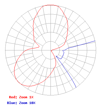 | ||||||||||||||||||
| Azimuth | Ratio | Azimuth | Ratio | Azimuth | Ratio | Azimuth | Ratio | ||||||||||||
| 0 | 1.000 | 10 | 0.980 | 20 | 0.860 | 30 | 0.740 | ||||||||||||
| 40 | 0.590 | 50 | 0.470 | 60 | 0.380 | 70 | 0.290 | ||||||||||||
| 80 | 0.070 | 90 | 0.030 | 100 | 0.030 | 110 | 0.030 | ||||||||||||
| 120 | 0.030 | 130 | 0.030 | 140 | 0.030 | 150 | 0.180 | ||||||||||||
| 160 | 0.340 | 170 | 0.420 | 180 | 0.530 | 190 | 0.670 | ||||||||||||
| 200 | 0.800 | 210 | 0.920 | 220 | 0.990 | 230 | 0.990 | ||||||||||||
| 240 | 0.920 | 250 | 0.800 | 260 | 0.670 | 270 | 0.530 | ||||||||||||
| 280 | 0.310 | 290 | 0.270 | 300 | 0.410 | 310 | 0.480 | ||||||||||||
| 320 | 0.590 | 330 | 0.740 | 340 | 0.860 | 350 | 0.980 | ||||||||||||
Structure Registration Number 1042810 [ASR Heights Differ from K24NS-D Application] Structure Type: BPOLE Registered To: HARRAH'S OPERATING COMPANY, INC. DBA = HARRAH'S CASINO, HOTEL-LAKE TAH Structure Address: 15 Highway 50 Stateline, NV County Name: Douglas County ASR Issued: 03/31/2003 Date Built: 01/01/1977 Site Elevation: 1915.4 m (6284 ft.) Structure Height: 68 m (223 ft.) Height Overall: 77.1 m (253 ft.) Overall Height AMSL: 1992.5 m (6537 ft.) FAA Determination: 04/06/1998 FAA Study #: 98-AWP-1144-OE Paint & Light FAA Chapters: None 38-57-35.0 N 119-56-24.0 W (NAD 83) 38-57-35.3 N 119-56-20.3 W (Converted to NAD 27) |
1600 Pearl Street Suite 300 Boulder, CO 80302 Phone: 855-688-0567 Limited Liability Company | Date: 02/05/2003 Application Certifier RSN WEST LLC P.o. Box 7528 Portland, ME 04112 Applicant JEFFREY L. DUMAIS P.o. Box 7528 Portland, ME 04112 VICE PRESIDENT BRENDAN HOLLAND, ESQ. Shaw Pittman Llp | |||||||||||||||||