
FCCInfo.com
A Service of Cavell, Mertz & Associates, Inc.
(855) FCC-INFO
|
|
|
|  |
|
|||||||||||||||
|
|
WGCS Channel: 216A 91.1 MHz Goshen, Indiana Service: FM - A full-service FM station or application. Facility ID: 24663 Fac. Service: FM Status: License Application Accepted: 03/13/1998 Application Granted: 03/11/2002 File Number: BLED-19980313KA License Expires: 00/00/0000 Prefix Type: This is a license for a noncommercial educational FM station Application Type: License To Cover FCC Website Links: LMS Facility Details This Application CDBS Application Other WGCS Applications Other WGCS Applications in CDBS Including Superseded Applications Mailing Address Correspondence for WGCS Correspondence related to application BLED-19980313KA Service Contour - Open Street Map or USGS Map (60 dBu) Service Contour - KML / Google Earth (60 dBu) Public Inspection Files History Cards for WGCS Facility Type: NON-COMMERCIAL EDUC. FM Class: A, A Zone I; I-A; or II station; with 0.1kW-6kW ERP and a class contour distance <=28km Site Location: 41-33-29.2 N 85-51-06.0 W (NAD 83) Site Location: 41-33-29.0 N 85-51-06.0 W (Converted to NAD 27) Effective Radiated Power: 6 kW Transmitter Output Power: 4.3 kW Antenna Center HAAT: 89 m (292 ft.) Antenna Center AMSL: 342 m (1122 ft.) Antenna Center HAG: 86 m (282 ft.) Site Elevation: 256 m. (840 ft.) Height Overall*: 92 m (302 ft.) (* As Filed In This Application, may differ from ASR Data, Below.) Directional Antenna Antenna Make/Model: Electronics Research Inc. LP-4E-DA-HW, 4 section, one-half wave spaced Antenna ID: 15054 Polarization: | ||||||||||||||||||
| Antenna Data for Antenna Id: 15054 WGCS FM File: BLED-19980313KA Electronics Research Inc. - LP-4E-DA-HW, 4 section, one-half wave spaced Service: FM | 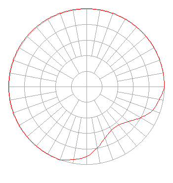 | ||||||||||||||||||
| Azimuth | Ratio | Azimuth | Ratio | Azimuth | Ratio | Azimuth | Ratio | ||||||||||||
| 0 | 1.000 | 10 | 1.000 | 20 | 1.000 | 30 | 1.000 | ||||||||||||
| 40 | 1.000 | 50 | 1.000 | 60 | 1.000 | 70 | 1.000 | ||||||||||||
| 80 | 1.000 | 90 | 1.000 | 100 | 0.950 | 110 | 0.900 | ||||||||||||
| 120 | 0.800 | 130 | 0.700 | 140 | 0.645 | 150 | 0.645 | ||||||||||||
| 160 | 0.700 | 170 | 0.800 | 180 | 0.900 | 190 | 0.950 | ||||||||||||
| 200 | 1.000 | 210 | 1.000 | 220 | 1.000 | 230 | 1.000 | ||||||||||||
| 240 | 1.000 | 250 | 1.000 | 260 | 1.000 | 270 | 1.000 | ||||||||||||
| 280 | 1.000 | 290 | 1.000 | 300 | 1.000 | 310 | 1.000 | ||||||||||||
| 320 | 1.000 | 330 | 1.000 | 340 | 1.000 | 350 | 1.000 | ||||||||||||
Structure Registration Number 1002245 Structure Type: TOWER Registered To: GOSHEN COLLEGE BROADCASTING CORP DBA = STATION WGCS Structure Address: Cr 21 2 Km Sw Goshen, IN County Name: Elkhart County ASR Issued: 09/13/1996 Date Built: 12/18/1997 Site Elevation: 256 m (840 ft.) Structure Height: 91 m (299 ft.) Height Overall: 92 m (302 ft.) Overall Height AMSL: 348 m (1142 ft.) FAA Determination: 07/23/1996 FAA Study #: 96-AGL-1558-OE FAA Circular #: 70/7460-1J Paint & Light FAA Chapters: 3, 4, 5, 13 Removed expiration and final dates from determination. Scenario 2./jjs/case#635066 41-33-29.0 N 85-51-06.0 W (NAD 83) 41-33-28.8 N 85-51-06.0 W (Converted to NAD 27) |
1700 South Main Street Goshen, IN 46526 Not-for-Profit | Date: 03/13/1998 Application Certifier GOSHEN COLLEGE BROADCASTING CORP. Goshen College 1700 South Main St. Goshen, IN 46526 Applicant | |||||||||||||||||