
FCCInfo.com
A Service of Cavell, Mertz & Associates, Inc.
(855) FCC-INFO
|
|
|
|
|
|||||||||||||||||||
|
|
KOKU Channel: 262C1 100.3 MHz Agana, Guam Service: FM - A full-service FM station or application. Facility ID: 25516 Fac. Service: FM Status: License Application Accepted: 09/13/2001 Application Granted: 11/26/2001 File Number: BMLH-20010913AAX License Expires: 00/00/0000 Prefix Type: This is a modification of a license for a commecial FM station Application Type: Minor Modification FCC Website Links: LMS Facility Details This Application CDBS Application Other KOKU Applications Other KOKU Applications in CDBS Including Superseded Applications Mailing Address Correspondence for KOKU Correspondence related to application BMLH-20010913AAX Service Contour - Open Street Map or USGS Map (60 dBu) Service Contour - KML / Google Earth (60 dBu) Public Inspection Files Facility Type: FM STATION Class: C1, A Zone II station; with 50kW-100kW ERP and a class contour distance 52km-72km Site Location: 13-29-17.0 N 144-49-35.0 E (NAD 83) Effective Radiated Power: 50 kW Horiz. ; 49.7 kW Vert. Transmitter Output Power: 4.5 kW Antenna Center HAAT: 165 m (541 ft.) Antenna Center AMSL: 237 m (778 ft.) Antenna Center HAG: 36 m (118 ft.) Site Elevation: 201 m. (659 ft.) Height Overall*: 43 m (141 ft.) (* As Filed In This Application, may differ from ASR Data, Below.) Directional Antenna Antenna Make/Model: R.F. Systems 904CP-4A, four section, 0.5 wavelength spaced Antenna ID: 30035 Polarization: | |||||||||||||||||||||
| Antenna Data for Antenna Id: 30035 KOKU FM File: BMLH-20010913AAX R.F. Systems - 904CP-4A, four section, 0.5 wavelength spaced Service: FM | 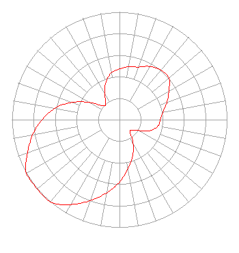 | |||||||||||||||||||||
| Azimuth | Ratio | Azimuth | Ratio | Azimuth | Ratio | Azimuth | Ratio | |||||||||||||||
| 0 | 0.470 | 10 | 0.500 | 20 | 0.520 | 30 | 0.570 | |||||||||||||||
| 40 | 0.600 | 50 | 0.600 | 60 | 0.530 | 70 | 0.470 | |||||||||||||||
| 80 | 0.410 | 90 | 0.380 | 100 | 0.360 | 110 | 0.300 | |||||||||||||||
| 120 | 0.200 | 130 | 0.150 | 140 | 0.150 | 150 | 0.250 | |||||||||||||||
| 160 | 0.360 | 170 | 0.460 | 180 | 0.580 | 190 | 0.690 | |||||||||||||||
| 200 | 0.800 | 210 | 0.910 | 220 | 1.000 | 230 | 1.000 | |||||||||||||||
| 240 | 1.000 | 250 | 0.910 | 260 | 0.820 | 270 | 0.720 | |||||||||||||||
| 280 | 0.610 | 290 | 0.470 | 300 | 0.320 | 310 | 0.200 | |||||||||||||||
| 320 | 0.200 | 330 | 0.270 | 340 | 0.370 | 350 | 0.440 | |||||||||||||||
Structure Registration Number 1204297 Structure Type: TOWER Registered To: Moy Communications, Inc. Structure Address: Mount Barrigada Agana, GU ASR Issued: 05/24/2004 Date Built: 04/17/2001 Site Elevation: 200.6 m (658 ft.) Structure Height: 42.4 m (139 ft.) Height Overall: 43.3 m (142 ft.) Overall Height AMSL: 243.9 m (800 ft.) FAA Determination: 08/27/1999 FAA Study #: 99-AWP-1224-OE FAA Circular #: 70/7460-1J Paint & Light FAA Chapters: 3, 4, 5, 13 Removed expiration date from determination. Scenario 1./jjs/case#635066 13-29-22.4 N 144-49-43.9 E (NAD 83) |
107 Julale Center 424 W. O'brien Drive Hagatna, GU 96910 Phone: 671-477-8613 Corporation | Date: 09/13/2001 Application Certifier GUAM RADIO SERVICES, INC. 508 W. O'brien Drive Hagatna, Guam, GU 96910-4926 Applicant ERNIE A. GALITO, GENERAL MANAGER DAVID KAUFMAN Brown, Nietert, And Kaufman, Chartered | ||||||||||||||||||||
|
| |||||||||||||||||||||