
FCCInfo.com
A Service of Cavell, Mertz & Associates, Inc.
(855) FCC-INFO
|
|
W229CM from 10/23/2013 |
|
|
||||||||||||||||
|
|
W229CM Channel: 229D 93.7 MHz Martinsburg, West Virginia Service: FX - A translator or application for a translator. Facility ID: 154324 Fac. Service: FX Programming Delivery Method: Unspecified Status: License Application Accepted: 07/25/2016 Application Granted: 08/01/2016 File Number: BLFT-20160725ABW License Expires: 00/00/0000 Prefix Type: This is a license for a translator Application Type: License To Cover FCC Website Links: LMS Facility Details This Application CDBS Application Other W229CM Applications Other W229CM Applications in CDBS Including Superseded Applications Mailing Address Correspondence for W229CM Correspondence related to application BLFT-20160725ABW Service Contour - Open Street Map or USGS Map (60 dBu) Service Contour - KML / Google Earth (60 dBu) Class: D, A Noncommercial educational operating with no more than 10W Site Location: 39-27-48.0 N 77-59-10.0 W (NAD 83) Site Location: 39-27-47.6 N 77-59-11.0 W (Converted to NAD 27) Effective Radiated Power: 0.25 kW Transmitter Output Power: 0.151 kW Antenna Center HAAT: 0 m Antenna Center AMSL: 226 m (741 ft.) Antenna Center HAG: 60 m (197 ft.) Site Elevation: 166 m. (545 ft.) Height Overall*: 68 m (223 ft.) (* As Filed In This Application, may differ from ASR Data, Below.) Directional Antenna Antenna Make/Model: None Antenna ID: 123690 Polarization:
| ||||||||||||||||||
| Antenna Data for Antenna Id: 123690 W229CM FX File: BLFT-20160725ABW None - Service: FX | 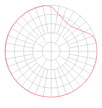 | ||||||||||||||||||
| Azimuth | Ratio | Azimuth | Ratio | Azimuth | Ratio | Azimuth | Ratio | ||||||||||||
| 0 | 0.960 | 10 | 0.840 | 20 | 0.750 | 30 | 0.700 | ||||||||||||
| 40 | 0.699 | 50 | 0.749 | 60 | 0.840 | 70 | 0.960 | ||||||||||||
| 80 | 1.000 | 90 | 1.000 | 100 | 1.000 | 110 | 1.000 | ||||||||||||
| 120 | 1.000 | 130 | 1.000 | 140 | 1.000 | 150 | 1.000 | ||||||||||||
| 160 | 1.000 | 170 | 1.000 | 180 | 1.000 | 190 | 1.000 | ||||||||||||
| 200 | 1.000 | 210 | 1.000 | 220 | 1.000 | 230 | 1.000 | ||||||||||||
| 240 | 1.000 | 250 | 1.000 | 260 | 1.000 | 270 | 1.000 | ||||||||||||
| 280 | 1.000 | 290 | 1.000 | 300 | 1.000 | 310 | 1.000 | ||||||||||||
| 320 | 1.000 | 330 | 1.000 | 340 | 1.000 | 350 | 1.000 | ||||||||||||
Structure Registration Number 1035789 Structure Type: TOWER Registered To: West Virginia Radio Corporation of the Alleghenies Structure Address: 1606 W King St Martinsburg, WV County Name: Berkeley County ASR Issued: 03/02/2015 Date Built: 01/01/1950 Site Elevation: 166 m (545 ft.) Structure Height: 68 m (223 ft.) Height Overall: 68 m (223 ft.) Overall Height AMSL: 234 m (768 ft.) Paint & Light FAA Chapters: 1, 3, 11, 21 39-27-48.0 N 77-59-10.0 W (NAD 83) 39-27-47.6 N 77-59-11.0 W (Converted to NAD 27) |
1251 Earl L. Core Road Morgantown, WV 26505 Phone: 304-554-3900 | Date: 07/25/2016 Application Certifier WEST VIRGINIA RADIO CORPORATION OF THE ALLEGHENIES 1251 Earl L. Core Road Morgantown, WV 26505 Applicant CHARLES F ELLIS Ellis Engineering 121 Merlot Drive Lafayette, LA 70503 CONSULTING ENGINEER FRANK R. JAZZO Fletcher, Heald & Hildreth, P.l.c. 1300 N. 17th Street 11th Floor Arlington, VA 22209 | |||||||||||||||||