
FCCInfo.com
A Service of Cavell, Mertz & Associates, Inc.
(855) FCC-INFO
|
|
K225CC from 03/11/2014 |
|
|
||||||||||||||||
|
|
K225CC Channel: 225D 92.9 MHz Corvallis, Oregon Service: FX - A translator or application for a translator. Facility ID: 156668 Fac. Service: FX Programming Delivery Method: Unspecified Status: License Application Accepted: 09/21/2015 Application Granted: 10/14/2015 File Number: BLFT-20150921ACG License Expires: 00/00/0000 Prefix Type: This is a license for a translator Application Type: License To Cover FCC Website Links: LMS Facility Details This Application CDBS Application Other K225CC Applications Other K225CC Applications in CDBS Including Superseded Applications Mailing Address Correspondence for K225CC Correspondence related to application BLFT-20150921ACG Service Contour - Open Street Map or USGS Map (60 dBu) Service Contour - KML / Google Earth (60 dBu) Class: D, A Noncommercial educational operating with no more than 10W Site Location: 44-38-24.4 N 123-16-29.4 W (NAD 83) Site Location: 44-38-25.0 N 123-16-25.0 W (Converted to NAD 27) Effective Radiated Power: 0.016 kW Transmitter Output Power: 0.036 kW Antenna Center HAAT: 0 m Antenna Center AMSL: 471 m (1545 ft.) Antenna Center HAG: 32 m (105 ft.) Site Elevation: 439 m. (1440 ft.) Height Overall*: 85 m (279 ft.) (* As Filed In This Application, may differ from ASR Data, Below.) Directional Antenna Antenna Make/Model: None Antenna ID: 120540 Polarization:
| ||||||||||||||||||
| Antenna Data for Antenna Id: 120540 K225CC FX File: BLFT-20150921ACG None - Service: FX Pattern and Field Values Include a 180° Clockwise Rotation | 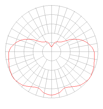 | ||||||||||||||||||
| Azimuth | Ratio | Azimuth | Ratio | Azimuth | Ratio | Azimuth | Ratio | ||||||||||||
| 0 | 0.103 | 10 | 0.130 | 20 | 0.205 | 30 | 0.243 | ||||||||||||
| 40 | 0.268 | 50 | 0.341 | 60 | 0.531 | 70 | 0.707 | ||||||||||||
| 80 | 0.837 | 90 | 0.917 | 100 | 0.936 | 110 | 0.970 | ||||||||||||
| 120 | 0.995 | 125 | 1.000 | 130 | 0.987 | 140 | 0.949 | ||||||||||||
| 150 | 0.876 | 160 | 0.836 | 170 | 0.905 | 180 | 0.937 | ||||||||||||
| 190 | 0.905 | 200 | 0.836 | 210 | 0.876 | 220 | 0.949 | ||||||||||||
| 230 | 0.987 | 235 | 1.000 | 240 | 0.995 | 250 | 0.970 | ||||||||||||
| 260 | 0.936 | 270 | 0.917 | 280 | 0.837 | 290 | 0.707 | ||||||||||||
| 300 | 0.531 | 310 | 0.341 | 320 | 0.268 | 330 | 0.243 | ||||||||||||
| 340 | 0.205 | 350 | 0.130 | ||||||||||||||||
Structure Registration Number 1035110 Structure Type: TOWER Registered To: Oregon Public Broadcasting Structure Address: Vineyard Hill 5 Mi N Corvallis, OR County Name: Benton County ASR Issued: 05/26/2020 Date Built: 05/01/1966 Site Elevation: 439 m (1440 ft.) Structure Height: 61 m (200 ft.) Height Overall: 85 m (279 ft.) Overall Height AMSL: 524 m (1719 ft.) FAA Determination: 03/04/1964 FAA Study #: WE-OE-3504 Paint & Light FAA Chapters: 1, 3, 11, 21 RED LIGHTS/PAINT 44-38-24.0 N 123-16-29.0 W (NAD 83) 44-38-24.6 N 123-16-24.6 W (Converted to NAD 27) |
1292 University Of Oregon Eugene, OR 97401-1292 Phone: 541-345-0800 | Date: 09/21/2015 Application Certifier UNIVERSITY OF OREGON 75 Centennial Loop Eugene, OR 97401 Applicant PAUL C BJORNSTAD 75 Centennial Loop Eugene, OR 97401 DIRECTOR OF BROADCASTING PAUL BJORNSTAD University Of Oregon 75 Centennial Loop Eugene, OR 97401 | |||||||||||||||||