
FCCInfo.com
A Service of Cavell, Mertz & Associates, Inc.
(855) FCC-INFO
|
|
WQLB from 12/01/1995 |
|  |
|
|||||||||||||||
|
|
WQLB Channel: 277C3 103.3 MHz Tawas City, Michigan Service: FM - A full-service FM station or application. Facility ID: 51746 Fac. Service: FM Status: License 73.215 Station Application Accepted: 06/16/1997 Application Granted: 09/25/1997 File Number: BLH-19970616KE License Expires: 00/00/0000 Prefix Type: This is a license for a commercial FM station Application Type: License To Cover FCC Website Links: LMS Facility Details This Application CDBS Application Other WQLB Applications Other WQLB Applications in CDBS Including Superseded Applications Mailing Address Correspondence for WQLB Correspondence related to application BLH-19970616KE Service Contour - Open Street Map or USGS Map (60 dBu) Service Contour - KML / Google Earth (60 dBu) Public Inspection Files Facility Type: FM STATION Class: C3, A Zone II station; with 6kW-25kW ERP and a class contour distance 28km-39km Site Location: 44-24-48.1 N 83-37-13.9 W (NAD 83) Site Location: 44-24-48.0 N 83-37-14.0 W (Converted to NAD 27) Effective Radiated Power: 15 kW Antenna Center HAAT: 129 m (423 ft.) Antenna Center AMSL: 362 m (1188 ft.) Antenna Center HAG: 112 m (367 ft.) Calculated Site Elevation: 250 m. (820 ft.) Height Overall*: 145 m (476 ft.) (* As Filed In This Application, may differ from ASR Data, Below.) Directional Antenna Antenna Make/Model: Oddball; usually designed by Applicant ODD960326IA Antenna ID: 14949 Polarization: | ||||||||||||||||||
| Antenna Data for Antenna Id: 14949 WQLB FM File: BLH-19970616KE Oddball; usually designed by Applicant - ODD960326IA Service: FM | 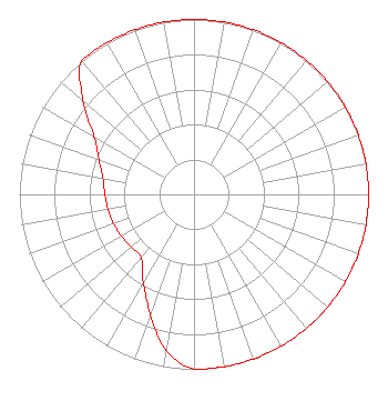 | ||||||||||||||||||
| Azimuth | Ratio | Azimuth | Ratio | Azimuth | Ratio | Azimuth | Ratio | ||||||||||||
| 0 | 1.000 | 10 | 1.000 | 20 | 1.000 | 30 | 1.000 | ||||||||||||
| 40 | 1.000 | 50 | 1.000 | 60 | 1.000 | 70 | 1.000 | ||||||||||||
| 80 | 1.000 | 90 | 1.000 | 100 | 1.000 | 110 | 1.000 | ||||||||||||
| 120 | 1.000 | 130 | 1.000 | 140 | 1.000 | 150 | 1.000 | ||||||||||||
| 160 | 1.000 | 170 | 1.000 | 180 | 1.000 | 190 | 0.910 | ||||||||||||
| 200 | 0.730 | 210 | 0.580 | 220 | 0.470 | 230 | 0.470 | ||||||||||||
| 240 | 0.480 | 250 | 0.490 | 260 | 0.500 | 270 | 0.510 | ||||||||||||
| 280 | 0.530 | 290 | 0.580 | 300 | 0.660 | 310 | 0.830 | ||||||||||||
| 320 | 1.000 | 330 | 1.000 | 340 | 1.000 | 350 | 1.000 | ||||||||||||
Structure Registration Number 1002615 [ASR Heights Differ from WQLB Application] Structure Type: TOWER Registered To: CARROLL ENTERPRISES INC Structure Address: 1450' Ne Of Int Monument And Shellenbarger Rds Tawas City, MI County Name: Iosco County ASR Issued: 10/03/1996 Date Built: 04/01/1987 Site Elevation: 250 m (820 ft.) Structure Height: 143 m (469 ft.) Height Overall: 144.5 m (474 ft.) Overall Height AMSL: 394.5 m (1294 ft.) FAA Determination: 08/28/1996 FAA Study #: 96-AGL-2688-OE FAA Circular #: 70/7460-1J Paint & Light FAA Chapters: 3, 4, 5, 13 44-24-48.0 N 83-37-14.0 W (NAD 83) 44-24-47.9 N 83-37-14.1 W (Converted to NAD 27) |
Tawas City, MI 48764 Phone: 989-362-3417 Corporation | Date: 06/16/1997 Application Certifier CARROLL BROADCASTING, INC. Carroll Broadcasting, Inc. P.o. Box 549 Tawas City, MI 48764 Applicant | |||||||||||||||||