
FCCInfo.com
A Service of Cavell, Mertz & Associates, Inc.
(855) FCC-INFO
|
|
|
|  |
|
|||||||||||||||
|
|
WRUR-FM Channel: 203B1 88.5 MHz Rochester, New York Service: FM - A full-service FM station or application. Facility ID: 69138 Fac. Service: FM Analog & Digital Status: License Application Accepted: 08/10/2011 Application Granted: 09/21/2011 File Number: BLED-20110810ABU License Expires: 00/00/0000 Prefix Type: This is a license for a noncommercial educational FM station Application Type: License To Cover FCC Website Links: LMS Facility Details This Application CDBS Application Other WRUR-FM Applications Other WRUR-FM Applications in CDBS Including Superseded Applications Mailing Address Correspondence for WRUR-FM Correspondence related to application BLED-20110810ABU Service Contour - Open Street Map or USGS Map (60 dBu) Service Contour - KML / Google Earth (60 dBu) Public Inspection Files History Cards for WRUR-FM Facility Type: NON-COMMERCIAL EDUC. FM Class: B1, A Zone I or I-A station; with 6kW-25kW ERP and a class contour distance 28km-39km Site Location: 43-08-07.2 N 77-35-02.0 W (NAD 83) Site Location: 43-08-07.0 N 77-35-03.0 W (Converted to NAD 27) Effective Radiated Power: 15.1 kW Transmitter Output Power: 15.8 kW Antenna Center HAAT: 115.3 m (378 ft.) Antenna Center AMSL: 262.9 m (863 ft.) Antenna Center HAG: 57.9 m (190 ft.) Calculated Site Elevation: 205 m. (673 ft.) Height Overall*: 105 m (344 ft.) (* As Filed In This Application, may differ from ASR Data, Below.) Directional Antenna Antenna Make/Model: Electronics Research Inc. 1097-1CP-DA Antenna ID: 101167 Polarization: | ||||||||||||||||||
| Antenna Data for Antenna Id: 101167 WRUR-FM FM File: BLED-20110810ABU Electronics Research Inc. - 1097-1CP-DA Service: FM | 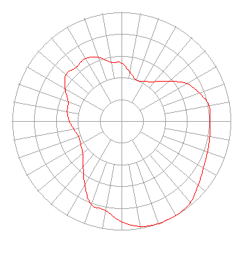 | ||||||||||||||||||
| Azimuth | Ratio | Azimuth | Ratio | Azimuth | Ratio | Azimuth | Ratio | ||||||||||||
| 0 | 0.533 | 10 | 0.451 | 20 | 0.401 | 30 | 0.420 | ||||||||||||
| 40 | 0.472 | 50 | 0.569 | 60 | 0.688 | 70 | 0.757 | ||||||||||||
| 80 | 0.812 | 90 | 0.812 | 100 | 0.820 | 110 | 0.836 | ||||||||||||
| 120 | 0.865 | 130 | 0.917 | 140 | 0.978 | 150 | 1.000 | ||||||||||||
| 160 | 1.000 | 170 | 0.982 | 180 | 0.924 | 190 | 0.833 | ||||||||||||
| 200 | 0.812 | 210 | 0.673 | 220 | 0.545 | 230 | 0.464 | ||||||||||||
| 240 | 0.430 | 250 | 0.418 | 260 | 0.442 | 270 | 0.478 | ||||||||||||
| 280 | 0.504 | 290 | 0.519 | 300 | 0.594 | 310 | 0.662 | ||||||||||||
| 320 | 0.644 | 330 | 0.660 | 340 | 0.622 | 350 | 0.549 | ||||||||||||
Structure Registration Number 1003958 Structure Type: TOWER Registered To: WXXI Public Broadcasting Council Inc. Structure Address: Pinnacle Hill Brighton, NY County Name: Monroe County ASR Issued: 03/27/2023 Date Built: 01/31/1980 Site Elevation: 205 m (673 ft.) Structure Height: 84 m (276 ft.) Height Overall: 105 m (344 ft.) Overall Height AMSL: 310 m (1017 ft.) Paint & Light FAA Chapters: 1, 3, 12, 21 43-08-07.0 N 77-35-02.0 W (NAD 83) 43-08-06.8 N 77-35-03.0 W (Converted to NAD 27) |
510 Wilson Commons Rochester, NY 14627 Phone: 585-275-4085 Not-for-Profit | Date: 08/10/2011 Application Certifier UNIVERSITY OF ROCHESTER BROADCAST CORP. 201 Wilson Commons Rochester, NY 14627-0281 Applicant BENJAMIN L. PIDEK, P.E. John F.x. Browne & Associates P.o. Box 1090 Bloomfield Hills, MI 48303 CONSULTING ENGINEER ANNE-MARIE ALGIER University Of Rochester Broadcast Corp. | |||||||||||||||||
| |||||||||||||||||||