
FCCInfo.com
A Service of Cavell, Mertz & Associates, Inc.
(855) FCC-INFO
|
|
|
|  |
|
|||||||||||||||
|
|
WSPB Channel: 209A 89.7 MHz Bedford, Michigan Service: FM - A full-service FM station or application. Facility ID: 172329 Fac. Service: FM Status: License Application Accepted: 05/15/2014 Application Granted: 05/23/2014 File Number: BLED-20140515AFJ License Expires: 00/00/0000 Prefix Type: This is a license for a noncommercial educational FM station Application Type: License To Cover FCC Website Links: LMS Facility Details This Application CDBS Application Other WSPB Applications Other WSPB Applications in CDBS Including Superseded Applications Mailing Address Correspondence for WSPB Correspondence related to application BLED-20140515AFJ Service Contour - Open Street Map or USGS Map (60 dBu) Service Contour - KML / Google Earth (60 dBu) Public Inspection Files Facility Type: NON-COMMERCIAL EDUC. FM Class: A, A Zone I; I-A; or II station; with 0.1kW-6kW ERP and a class contour distance <=28km Site Location: 42-27-27.1 N 85-14-53.0 W (NAD 83) Site Location: 42-27-27.0 N 85-14-53.0 W (Converted to NAD 27) Effective Radiated Power: 4.5 kW Transmitter Output Power: 3.5 kW Antenna Center HAAT: 75 m (246 ft.) Antenna Center AMSL: 354 m (1161 ft.) Antenna Center HAG: 64 m (210 ft.) Calculated Site Elevation: 290 m. (951 ft.) Height Overall*: 77 m (253 ft.) (* As Filed In This Application, may differ from ASR Data, Below.) Directional Antenna Antenna Make/Model: Shivley 6025-1/1/2-DA, three sections Antenna ID: 117564 Polarization:
| ||||||||||||||||||
| Antenna Data for Antenna Id: 117564 WSPB FM File: BLED-20140515AFJ Shivley - 6025-1/1/2-DA, three sections Service: FM | 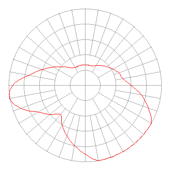 | ||||||||||||||||||
| Azimuth | Ratio | Azimuth | Ratio | Azimuth | Ratio | Azimuth | Ratio | ||||||||||||
| 0 | 0.265 | 10 | 0.265 | 20 | 0.265 | 30 | 0.297 | ||||||||||||
| 40 | 0.334 | 50 | 0.374 | 60 | 0.420 | 70 | 0.471 | ||||||||||||
| 80 | 0.500 | 90 | 0.600 | 100 | 0.750 | 110 | 0.880 | ||||||||||||
| 120 | 1.000 | 130 | 1.000 | 140 | 1.000 | 150 | 1.000 | ||||||||||||
| 160 | 1.000 | 170 | 1.000 | 180 | 0.900 | 190 | 0.800 | ||||||||||||
| 200 | 0.700 | 210 | 0.600 | 220 | 0.500 | 230 | 0.596 | ||||||||||||
| 240 | 0.705 | 250 | 0.888 | 260 | 1.000 | 270 | 0.941 | ||||||||||||
| 280 | 0.747 | 290 | 0.593 | 300 | 0.471 | 310 | 0.374 | ||||||||||||
| 320 | 0.297 | 330 | 0.265 | 340 | 0.265 | 350 | 0.265 | ||||||||||||
Structure Registration Number 1213717 Structure Type: TOWER Registered To: Crown Castle Towers 05 LLC Structure Address: 13475 S. M-37 Hwy Battle Creek, MI County Name: Barry County ASR Issued: 05/06/2016 Date Built: 03/07/2005 Site Elevation: 289.9 m (951 ft.) Structure Height: 73.7 m (242 ft.) Height Overall: 77.4 m (254 ft.) Overall Height AMSL: 367.3 m (1205 ft.) FAA Determination: 09/28/2006 FAA Study #: 2006-AGL-6936-OE FAA Circular #: 70/7460-1K Paint & Light FAA Chapters: 4, 8, 12 PRIOR STUDY 2005-AGL-306-OE 42-27-27.2 N 85-14-52.6 W (NAD 83) 42-27-27.1 N 85-14-52.6 W (Converted to NAD 27) |
2504 Ardmore Street, S.e. Grand Rapids, MI 49506 Phone: 616-956-1140 | Date: 05/15/2014 Application Certifier HOLY FAMILY RADIO, INC. 2504 Ardmore Street, S.e. Grand Rapids, MI 49506 Applicant DENNIS J. KELLY Law Office Of Dennis J. Kelly Post Office Box 41177 Washington, DC 20018-0577 ATTORNEY/CONSULTANT DENNIS J. KELLY Law Office Of Dennis J. Kelly | |||||||||||||||||