
FCCInfo.com
A Service of Cavell, Mertz & Associates, Inc.
(855) FCC-INFO
|
|
WHAA from 08/26/1998 |
|
|
||||||||||||||||
|
|
WHAA Channel: 206C2 89.1 MHz Adams, Wisconsin Service: FM - A full-service FM station or application. Facility ID: 91555 Fac. Service: FM Analog & Digital Status: License Application Accepted: 02/12/2010 Application Granted: 03/31/2010 File Number: BLED-20100212AAK License Expires: 00/00/0000 Prefix Type: This is a license for a noncommercial educational FM station Application Type: Amendment FCC Website Links: LMS Facility Details This Application CDBS Application Other WHAA Applications Other WHAA Applications in CDBS Including Superseded Applications Mailing Address Correspondence for WHAA Correspondence related to application BLED-20100212AAK Service Contour - Open Street Map or USGS Map (60 dBu) Service Contour - KML / Google Earth (60 dBu) Public Inspection Files Facility Type: NON-COMMERCIAL EDUC. FM Class: C2, A Zone II station; with 25kW-50kW ERP and a class contour distance 39km-52km Site Location: 44-01-12.9 N 89-33-31.4 W (NAD 83) Site Location: 44-01-13.0 N 89-33-31.0 W (Converted to NAD 27) Effective Radiated Power: 28.5 kW Transmitter Output Power: 10.25 kW Antenna Center HAAT: 177 m (581 ft.) Antenna Center AMSL: 487 m (1598 ft.) Antenna Center HAG: 144 m (472 ft.) Calculated Site Elevation: 343 m. (1125 ft.) Height Overall*: 150.9 m (495 ft.) (* As Filed In This Application, may differ from ASR Data, Below.) Directional Antenna Antenna Make/Model: Shivley 6810-3D-DA Antenna ID: 98281 Polarization: | ||||||||||||||||||
| Antenna Data for Antenna Id: 98281 WHAA FM File: BLED-20100212AAK Shivley - 6810-3D-DA Service: FM | 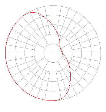 | ||||||||||||||||||
| Azimuth | Ratio | Azimuth | Ratio | Azimuth | Ratio | Azimuth | Ratio | ||||||||||||
| 0 | 0.567 | 10 | 0.451 | 20 | 0.358 | 30 | 0.284 | ||||||||||||
| 40 | 0.226 | 50 | 0.190 | 60 | 0.180 | 70 | 0.178 | ||||||||||||
| 80 | 0.180 | 90 | 0.190 | 100 | 0.226 | 110 | 0.284 | ||||||||||||
| 120 | 0.358 | 130 | 0.451 | 140 | 0.567 | 150 | 0.714 | ||||||||||||
| 160 | 0.879 | 170 | 0.975 | 180 | 1.000 | 190 | 1.000 | ||||||||||||
| 200 | 1.000 | 210 | 1.000 | 220 | 1.000 | 230 | 1.000 | ||||||||||||
| 240 | 1.000 | 250 | 1.000 | 260 | 1.000 | 270 | 1.000 | ||||||||||||
| 280 | 1.000 | 290 | 1.000 | 300 | 1.000 | 310 | 1.000 | ||||||||||||
| 320 | 1.000 | 330 | 0.975 | 340 | 0.879 | 350 | 0.714 | ||||||||||||
Structure Registration Number 1053337 Structure Type: TOWER Registered To: American Towers LLC Structure Address: W13685 State Hwy 21 Coloma, WI County Name: Waushara County ASR Issued: 10/02/2017 Date Built: 01/01/2010 Site Elevation: 343 m (1125 ft.) Structure Height: 149.9 m (492 ft.) Height Overall: 150.9 m (495 ft.) Overall Height AMSL: 493.9 m (1620 ft.) FAA Determination: 12/23/2009 FAA Study #: 2009-AGL-6373-OE FAA Circular #: 70/7460-1K Paint & Light FAA Chapters: 3, 4, 5, 12 PRIOR STUDY 2009-AGL-2054-OE 44-01-12.8 N 89-33-31.3 W (NAD 83) 44-01-12.9 N 89-33-30.9 W (Converted to NAD 27) |
3319 W. Beltline Hwy Madison, WI 53713 Phone: 608-264-9600 Government Entity | Date: 02/12/2010 Application Certifier STATE OF WISCONSIN - EDUCATIONAL COMMUNICATIONS BOARD 3319 W. Beltline Hwy. Madison, WI 53713 Applicant STEPHEN M. BAUDER 3319 W. Beltline Hwy Madison, WI 53713 STAFF ENGINEER MARGARET L. MILLER Dow Lohnes Pllc | |||||||||||||||||