
FCCInfo.com
A Service of Cavell, Mertz & Associates, Inc.
(855) FCC-INFO
|
|
|
|
|
||||||||||||||||
|
|
WGEL Channel: 269A 101.7 MHz Greenville, Illinois Service: FM - A full-service FM station or application. Facility ID: 6343 Fac. Service: FM Status: License Application Accepted: 07/17/2009 Application Granted: 08/06/2009 File Number: BLH-20090717ADL License Expires: 00/00/0000 Prefix Type: This is a license for a commercial FM station Application Type: License To Cover FCC Website Links: LMS Facility Details This Application CDBS Application Other WGEL Applications Other WGEL Applications in CDBS Including Superseded Applications Mailing Address Correspondence for WGEL Correspondence related to application BLH-20090717ADL Service Contour - Open Street Map or USGS Map (60 dBu) Service Contour - KML / Google Earth (60 dBu) Public Inspection Files Facility Type: FM STATION Class: A, A Zone I; I-A; or II station; with 0.1kW-6kW ERP and a class contour distance <=28km Site Location: 38-48-11.2 N 89-20-56.3 W (NAD 83) Site Location: 38-48-11.0 N 89-20-56.0 W (Converted to NAD 27) Effective Radiated Power: 6 kW Transmitter Output Power: 2.82 kW Antenna Center HAAT: 90 m (295 ft.) Antenna Center AMSL: 238 m (781 ft.) Antenna Center HAG: 86 m (282 ft.) Calculated Site Elevation: 152 m. (499 ft.) Height Overall*: 91 m (299 ft.) (* As Filed In This Application, may differ from ASR Data, Below.) Directional Antenna Antenna Make/Model: Shivley 6810-3R-DA, three sections Antenna ID: 84539 Polarization:
| ||||||||||||||||||
| Antenna Data for Antenna Id: 84539 WGEL FM File: BLH-20090717ADL Shivley - 6810-3R-DA, three sections Service: FM | 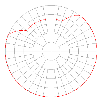 | ||||||||||||||||||
| Azimuth | Ratio | Azimuth | Ratio | Azimuth | Ratio | Azimuth | Ratio | ||||||||||||
| 0 | 0.700 | 10 | 0.700 | 20 | 0.700 | 30 | 0.870 | ||||||||||||
| 40 | 1.000 | 50 | 1.000 | 60 | 1.000 | 70 | 1.000 | ||||||||||||
| 80 | 1.000 | 90 | 1.000 | 100 | 1.000 | 110 | 1.000 | ||||||||||||
| 120 | 1.000 | 130 | 1.000 | 140 | 1.000 | 150 | 1.000 | ||||||||||||
| 160 | 1.000 | 170 | 1.000 | 180 | 1.000 | 190 | 1.000 | ||||||||||||
| 200 | 1.000 | 210 | 1.000 | 220 | 1.000 | 230 | 1.000 | ||||||||||||
| 240 | 1.000 | 250 | 1.000 | 260 | 1.000 | 270 | 1.000 | ||||||||||||
| 280 | 1.000 | 290 | 1.000 | 300 | 0.870 | 310 | 0.700 | ||||||||||||
| 320 | 0.700 | 330 | 0.700 | 340 | 0.700 | 350 | 0.700 | ||||||||||||
Structure Registration Number 1011471 Structure Type: TOWER Registered To: KENNEDY, JOHN DBA = BOND BROADCASTING Structure Address: 1.2 Mi E Of Rt 127 7 Mi Se Greenville, IL County Name: Bond County ASR Issued: 03/14/1997 Date Built: 01/01/1984 Site Elevation: 152.4 m (500 ft.) Structure Height: 90.2 m (296 ft.) Height Overall: 91.4 m (300 ft.) Overall Height AMSL: 243.8 m (800 ft.) FAA Determination: 01/02/1997 FAA Study #: 96-AGL-4221-OE FAA Circular #: 70/7460-1J Paint & Light FAA Chapters: 3, 4, 5, 13 38-48-11.0 N 89-20-56.0 W (NAD 83) 38-48-10.8 N 89-20-55.7 W (Converted to NAD 27) |
309 W. Main Ave. Greenville, IL 62246 Phone: 618-664-3300 Corporation | Date: 07/17/2009 Application Certifier BOND BROADCASTING, INC. 309 W. Main Ave. Greenville, IL 62246 Applicant CHARLES M. ANDERSON 1519 Euclid Avenue Bowling Green, KY 42103 CONSULTANT JOHN F. GARZIGLIA, ESQ. Womble Carlyle Sandridge & Rice, Pllc | |||||||||||||||||
|
| ||||||||||||||||||