
FCCInfo.com
A Service of Cavell, Mertz & Associates, Inc.
(855) FCC-INFO
|
|
WDTR from 04/11/2011 WDTR from 08/09/2004 WDTR from 12/01/2000 |
|
|
||||||||||||||||
|
|
WDTR Channel: 205B1 88.9 MHz Imlay City, Michigan Service: FM - A full-service FM station or application. Facility ID: 92635 Fac. Service: FM Status: Construction Permit Application Accepted: 08/18/2021 Application Granted: 01/20/2022 File Number: -0000157613 WDTR CP Expires: 01/20/2025 Application Type: Minor Modification FCC Website Links: LMS Facility Details This Application Other WDTR Applications Other WDTR Applications in CDBS Including Superseded Applications Mailing Address Correspondence for WDTR Correspondence related to application -0000157613 Service Contour - Open Street Map or USGS Map (60 dBu) Service Contour - KML / Google Earth (60 dBu) Public Inspection Files Facility Type: NON-COMMERCIAL EDUC. FM Class: B1, A Zone I or I-A station; with 6kW-25kW ERP and a class contour distance 28km-39km Site Location: 42-48-23.9 N 83-10-44.7 W (NAD 83) Site Location: 42-48-23.8 N 83-10-44.9 W (Converted to NAD 27) Effective Radiated Power: 7.4 kW Antenna Center HAAT: 78 m (256 ft.) Antenna Center AMSL: 371 m (1217 ft.) Antenna Center HAG: 46 m (151 ft.) Site Elevation: 324.9 m. (1066 ft.) Height Overall*: 60.6 m (199 ft.) (* As Filed In This Application, may differ from ASR Data, Below.) Directional Antenna Antenna Make/Model: None Antenna ID: 125029 Polarization:
| ||||||||||||||||||
| Antenna Data for Antenna Id: 125029 WDTR FM File: -0000157613 None - Service: FM | 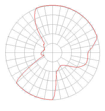 | ||||||||||||||||||
| Azimuth | Ratio | Azimuth | Ratio | Azimuth | Ratio | Azimuth | Ratio | ||||||||||||
| 0 | 1.000 | 10 | 1.000 | 20 | 1.000 | 30 | 1.000 | ||||||||||||
| 40 | 1.000 | 50 | 1.000 | 60 | 1.000 | 70 | 1.000 | ||||||||||||
| 80 | 0.879 | 90 | 0.755 | 100 | 0.756 | 110 | 0.736 | ||||||||||||
| 120 | 0.620 | 130 | 0.443 | 140 | 0.352 | 150 | 0.331 | ||||||||||||
| 160 | 0.374 | 170 | 0.471 | 180 | 1.000 | 190 | 1.000 | ||||||||||||
| 200 | 1.000 | 210 | 1.000 | 220 | 1.000 | 230 | 1.000 | ||||||||||||
| 240 | 0.465 | 250 | 0.202 | 260 | 0.248 | 270 | 0.232 | ||||||||||||
| 280 | 0.201 | 290 | 0.178 | 300 | 0.202 | 310 | 0.248 | ||||||||||||
| 320 | 0.300 | 330 | 0.724 | 340 | 1.000 | 350 | 1.000 | ||||||||||||
Structure Registration Number 1273797 Structure Type: TOWER Registered To: SBA 2012 TC Assets, LLC Structure Address: 998 Lake George Road Leonard, MI County Name: Oakland County ASR Issued: 01/14/2013 Date Built: 08/07/2002 Site Elevation: 324.9 m (1066 ft.) Structure Height: 59.4 m (195 ft.) Height Overall: 60.6 m (199 ft.) Overall Height AMSL: 385.5 m (1265 ft.) FAA Determination: 03/31/2010 FAA Study #: 2010-AGL-1312-OE Paint & Light FAA Chapters: NONE 42-48-23.9 N 83-10-44.7 W (NAD 83) 42-48-23.8 N 83-10-44.9 W (Converted to NAD 27) |
172 N Cedar St Imlay City, MI 48444 Phone: 810-895-2040 Not-for-Profit | Title: President Date: 08/18/2021 Application Certifier Michigan Community Radio 172 N Cedar St Imlay City, MI 48444 Applicant EDWARD CZELADA Michigan Community Radio 3302 N Van Dyke Rd Imlay City, MI 48444 PRESIDENT | |||||||||||||||||
| |||||||||||||||||||