
FCCInfo.com
A Service of Cavell, Mertz & Associates, Inc.
(855) FCC-INFO
|
|
|
|
|
||||||||||||||||
|
|
WLGH Channel: 201B 88.1 MHz Leroy Township, Michigan Service: FM - A full-service FM station or application. Facility ID: 78460 Fac. Service: FM Status: Construction Permit Application Accepted: 10/04/2021 Application Granted: 02/10/2022 File Number: -0000162805 WLGH CP Expires: 02/10/2025 Application Type: Minor Modification FCC Website Links: LMS Facility Details This Application Other WLGH Applications Other WLGH Applications in CDBS Including Superseded Applications Mailing Address Correspondence for WLGH Correspondence related to application -0000162805 Service Contour - Open Street Map or USGS Map (60 dBu) Service Contour - KML / Google Earth (60 dBu) Public Inspection Files Facility Type: NON-COMMERCIAL EDUC. FM Class: B, A Zone I or I-A station; with 25kW-50kW ERP and a class contour distance 39km-52km Site Location: 42-42-20.4 N 84-21-27.3 W (NAD 83) Site Location: 42-42-20.3 N 84-21-27.4 W (Converted to NAD 27) Effective Radiated Power: 0.001 kW Horiz. ; 33 kW Vert. Antenna Center HAAT: 174 m (571 ft.) Antenna Center AMSL: 444 m (1457 ft.) Antenna Center HAG: 172 m (564 ft.) Site Elevation: 271.6 m. (891 ft.) Height Overall*: 185.9 m (610 ft.) (* As Filed In This Application, may differ from ASR Data, Below.) Directional Antenna Antenna Make/Model: None Antenna ID: 1006063 Polarization:
| ||||||||||||||||||
| Antenna Data for Antenna Id: 1006063 WLGH FM File: -0000162805 None - Service: FM | 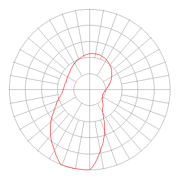 | ||||||||||||||||||
| Azimuth | Ratio | Azimuth | Ratio | Azimuth | Ratio | Azimuth | Ratio | ||||||||||||
| 0 | 0.443 | 10 | 0.448 | 20 | 0.443 | 30 | 0.423 | ||||||||||||
| 40 | 0.395 | 50 | 0.360 | 60 | 0.317 | 70 | 0.276 | ||||||||||||
| 80 | 0.238 | 90 | 0.207 | 100 | 0.185 | 110 | 0.178 | ||||||||||||
| 120 | 0.185 | 130 | 0.207 | 140 | 0.261 | 150 | 0.328 | ||||||||||||
| 160 | 0.552 | 170 | 0.776 | 180 | 1.000 | 190 | 1.000 | ||||||||||||
| 200 | 1.000 | 210 | 0.875 | 220 | 0.751 | 230 | 0.626 | ||||||||||||
| 240 | 0.501 | 250 | 0.422 | 260 | 0.355 | 270 | 0.324 | ||||||||||||
| 280 | 0.314 | 290 | 0.306 | 300 | 0.314 | 310 | 0.324 | ||||||||||||
| 320 | 0.348 | 330 | 0.373 | 340 | 0.399 | 350 | 0.423 | ||||||||||||
Structure Registration Number 1201878 Structure Type: TOWER Registered To: SBA Structures, LLC Structure Address: 185 E. Grand Avenue Williamston, MI County Name: Ingham County ASR Issued: 04/26/2013 Date Built: 01/01/1979 Site Elevation: 271.6 m (891 ft.) Structure Height: 181.4 m (595 ft.) Height Overall: 185.9 m (610 ft.) Overall Height AMSL: 457.5 m (1501 ft.) FAA Determination: 10/21/1999 FAA Study #: 99-AGL-4569-OE FAA Circular #: 70/7460-1J Paint & Light FAA Chapters: 4, 8, 13 PRIOR FAA 86-AGL-2387-OE 42-42-20.4 N 84-21-27.3 W (NAD 83) 42-42-20.3 N 84-21-27.4 W (Converted to NAD 27) |
172 N Cedar St Imlay City, MI 48444 Phone: 810-895-2040 Not-for-Profit | Title: President Date: 10/04/2021 Application Certifier SMILE FM Smile Fm 172 N Cedar St Imlay City, MI 48444 Applicant Edward Czelada Smile Fm 3302 N. Van Dyke Imlay City, MI 48444 | |||||||||||||||||