
FCCInfo.com
A Service of Cavell, Mertz & Associates, Inc.
(855) FCC-INFO
|
|
|
|
|
||||||||||||||||
|
|
Channel: 218B1 91.5 MHz Delafield, Wisconsin Service: FM - A full-service FM station or application. Facility ID: 768344 Fac. Service: FM Status: Construction Permit Application Accepted: 01/31/2022 Application Pending: 02/01/2022 File Number: -0000167847 CP Expires: 00/00/0000 Application Type: Non-Commercial Educational Amendment FCC Website Links: LMS Facility Details This Application Other Applications Other Applications in CDBS Including Superseded Applications Mailing Address Correspondence for Correspondence related to application -0000167847 Service Contour - Open Street Map or USGS Map (60 dBu) Service Contour - KML / Google Earth (60 dBu) Facility Type: NON-COMMERCIAL EDUC. FM Class: B1, A Zone I or I-A station; with 6kW-25kW ERP and a class contour distance 28km-39km Site Location: 43-11-23.6 N 88-28-01.4 W (NAD 83) Site Location: 43-11-23.6 N 88-28-01.0 W (Converted to NAD 27) Effective Radiated Power: 14 kW Antenna Center HAAT: 48 m (157 ft.) Antenna Center AMSL: 331 m (1086 ft.) Antenna Center HAG: 41 m (135 ft.) Site Elevation: 290.5 m. (953 ft.) Height Overall*: 60.7 m (199 ft.) (* As Filed In This Application, may differ from ASR Data, Below.) Directional Antenna Antenna Make/Model: None Antenna ID: 69-2019-08-06 Polarization: | ||||||||||||||||||
| Antenna Data for Antenna Id: 69-2019-08-06 FM File: -0000167847 None - Service: FM | 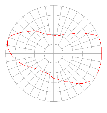 | ||||||||||||||||||
| Azimuth | Ratio | Azimuth | Ratio | Azimuth | Ratio | Azimuth | Ratio | ||||||||||||
| 0 | 0.377 | 10 | 0.373 | 20 | 0.399 | 30 | 0.462 | ||||||||||||
| 40 | 0.530 | 50 | 0.660 | 60 | 0.822 | 70 | 1.000 | ||||||||||||
| 80 | 1.000 | 90 | 1.000 | 100 | 1.000 | 110 | 1.000 | ||||||||||||
| 120 | 1.000 | 130 | 0.924 | 140 | 0.821 | 150 | 0.688 | ||||||||||||
| 160 | 0.613 | 170 | 0.545 | 180 | 0.515 | 190 | 0.444 | ||||||||||||
| 200 | 0.432 | 210 | 0.437 | 220 | 0.453 | 230 | 0.487 | ||||||||||||
| 240 | 0.564 | 250 | 0.677 | 260 | 0.781 | 270 | 0.891 | ||||||||||||
| 280 | 0.972 | 290 | 0.976 | 300 | 0.846 | 310 | 0.703 | ||||||||||||
| 320 | 0.614 | 330 | 0.497 | 340 | 0.426 | 350 | 0.396 | ||||||||||||
Structure Registration Number 1221965 Structure Type: LTOWER Registered To: SBA Structures, LLC Structure Address: W359 N9317 Brown Street (wi20118-a) Oconomowoc, WI County Name: Waukesha County ASR Issued: 05/15/2023 Date Built: 04/04/2001 Site Elevation: 290.5 m (953 ft.) Structure Height: 57.9 m (190 ft.) Height Overall: 60.7 m (199 ft.) Overall Height AMSL: 351.2 m (1152 ft.) FAA Determination: 12/01/2022 FAA Study #: 2022-AGL-1107-OE Paint & Light FAA Chapters: NONE PRIOR STUDY 2000-AGL-9023-OE 43-11-23.6 N 88-28-01.4 W (NAD 83) 43-11-23.6 N 88-28-01.0 W (Converted to NAD 27) |
Title: President Date: 01/31/2022 Application Certifier Optima Enrichment, Inc. 4020 N 128th St Brookfield, WI 53005 Applicant Martin Gibbs Broadcast Technical Partners, Llc Pasco, WA 99302 | ||||||||||||||||||