
FCCInfo.com
A Service of Cavell, Mertz & Associates, Inc.
(855) FCC-INFO
|
|
W222CW from 02/23/2016 W222CW from 01/07/2016 |
|
|
||||||||||||||||
|
|
W222CW Channel: 222D 92.3 MHz Charlotte, North Carolina Service: FX - A translator or application for a translator. Facility ID: 146299 Fac. Service: FX Programming Delivery Method: Unspecified Status: Construction Permit Application Accepted: 02/01/2022 Application Granted: 02/23/2022 File Number: -0000183892 W222CW CP Expires: 02/22/2025 Application Type: Minor Modification FCC Website Links: LMS Facility Details This Application Other W222CW Applications Other W222CW Applications in CDBS Including Superseded Applications Mailing Address Correspondence for W222CW Correspondence related to application -0000183892 Service Contour - Open Street Map or USGS Map (60 dBu) Service Contour - KML / Google Earth (60 dBu) Facility Type: FM STATION Class: D, A Noncommercial educational operating with no more than 10W Site Location: 35-16-34.5 N 80-47-58.9 W (NAD 83) Site Location: 35-16-34.0 N 80-47-59.6 W (Converted to NAD 27) Effective Radiated Power: 0.12 kW Antenna Center HAAT: 0 m Antenna Center AMSL: 397.7 m (1305 ft.) Antenna Center HAG: 167.6 m (550 ft.) Site Elevation: 230.1 m. (755 ft.) Height Overall*: 184.4 m (605 ft.) (* As Filed In This Application, may differ from ASR Data, Below.) Directional Antenna Antenna Make/Model: Scala 3xCL-FM/SRM/SV Antenna ID: 134201 Polarization: H
| ||||||||||||||||||
| Antenna Data for Antenna Id: 134201 W222CW FX File: -0000183892 Scala - 3xCL-FM/SRM/SV Service: FX | 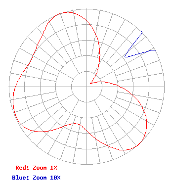 | ||||||||||||||||||
| Azimuth | Ratio | Azimuth | Ratio | Azimuth | Ratio | Azimuth | Ratio | ||||||||||||
| 0 | 0.844 | 10 | 0.682 | 20 | 0.494 | 30 | 0.317 | ||||||||||||
| 40 | 0.174 | 50 | 0.068 | 60 | 0.090 | 70 | 0.174 | ||||||||||||
| 80 | 0.285 | 90 | 0.428 | 100 | 0.595 | 110 | 0.757 | ||||||||||||
| 120 | 0.891 | 130 | 0.976 | 137 | 1.000 | 138 | 1.000 | ||||||||||||
| 139 | 1.000 | 140 | 0.999 | 150 | 0.942 | 160 | 0.810 | ||||||||||||
| 170 | 0.680 | 180 | 0.566 | 190 | 0.498 | 200 | 0.508 | ||||||||||||
| 210 | 0.589 | 220 | 0.744 | 230 | 0.887 | 240 | 0.972 | ||||||||||||
| 250 | 0.980 | 260 | 0.957 | 270 | 0.912 | 280 | 0.849 | ||||||||||||
| 290 | 0.799 | 300 | 0.792 | 310 | 0.822 | 320 | 0.874 | ||||||||||||
| 330 | 0.958 | 340 | 0.996 | 350 | 0.957 | ||||||||||||||
Structure Registration Number 1017067 Structure Type: TOWER Registered To: Pinnacle Towers LLC Structure Address: Sugar Creek Rd Charlotte, NC County Name: Mecklenburg County ASR Issued: 05/06/2016 Date Built: 02/02/2004 Site Elevation: 230.1 m (755 ft.) Structure Height: 176.8 m (580 ft.) Height Overall: 184.4 m (605 ft.) Overall Height AMSL: 414.5 m (1360 ft.) FAA Determination: 09/20/2010 FAA Study #: 2010-ASO-4596-OE FAA Circular #: 70/7460-1K Paint & Light FAA Chapters: 4, 9, 12 PRIOR STUDY 2010-ASO-216-OE 35-16-34.5 N 80-47-58.9 W (NAD 83) 35-16-34.0 N 80-47-59.6 W (Converted to NAD 27) |
1115 Honeysuckle Drive Keene, TX 76059 Phone: 817-641-3495 Not-for-Profit | Title: President Date: 02/01/2022 Application Certifier FAMILY FIRST Family First 1115 Honeysuckle Drive Keene, TX 76059 Applicant William J. Getz Carl T. Jones Corporation 7901 Yarnwood Ct Springfield, VA 22153 Consulting Engineer DONALD MARTIN Donald E. Martin, P.c. Falls Church, VA 22041 Attorney | |||||||||||||||||