
FCCInfo.com
A Service of Cavell, Mertz & Associates, Inc.
(855) FCC-INFO
|
|
W285ER from 10/02/1997 |
|
|
||||||||||||||||
|
|
W285ER Channel: 285D 104.9 MHz Prospect, Kentucky Service: FX - A translator or application for a translator. Facility ID: 86302 Fac. Service: FX Programming Delivery Method: Unspecified Status: Construction Permit Application Accepted: 12/27/2022 Application Granted: 01/18/2023 File Number: -0000205937 W285ER CP Expires: 01/17/2026 Application Type: Minor Modification FCC Website Links: LMS Facility Details This Application Other W285ER Applications Other W285ER Applications in CDBS Including Superseded Applications Mailing Address Correspondence for W285ER Correspondence related to application -0000205937 Service Contour - Open Street Map or USGS Map (60 dBu) Service Contour - KML / Google Earth (60 dBu) Facility Type: FM STATION Class: D, A Noncommercial educational operating with no more than 10W Site Location: 38-23-47.0 N 85-35-17.3 W (NAD 83) Site Location: 38-23-46.8 N 85-35-17.4 W (Converted to NAD 27) Effective Radiated Power: 0.25 kW Antenna Center HAAT: 56 m Horiz.; 0 m Vert. Antenna Center AMSL: 269.2 m (883 ft.) Antenna Center HAG: 58 m (190 ft.) Site Elevation: 211.2 m. (693 ft.) Height Overall*: 83.8 m (275 ft.) (* As Filed In This Application, may differ from ASR Data, Below.) Directional Antenna Antenna Make/Model: Scala CA2-CP Composite Antenna ID: 16150 Polarization: H
| ||||||||||||||||||
| Antenna Data for Antenna Id: 16150 W285ER FX File: -0000205937 Scala - CA2-CP Composite Service: FX | 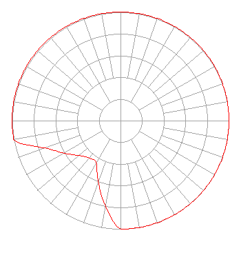 | ||||||||||||||||||
| Azimuth | Ratio | Azimuth | Ratio | Azimuth | Ratio | Azimuth | Ratio | ||||||||||||
| 0 | 1.000 | 10 | 1.000 | 20 | 1.000 | 30 | 1.000 | ||||||||||||
| 40 | 1.000 | 50 | 1.000 | 60 | 1.000 | 70 | 1.000 | ||||||||||||
| 80 | 1.000 | 90 | 1.000 | 100 | 1.000 | 110 | 1.000 | ||||||||||||
| 120 | 1.000 | 130 | 1.000 | 140 | 1.000 | 150 | 1.000 | ||||||||||||
| 160 | 1.000 | 170 | 1.000 | 180 | 1.000 | 190 | 0.800 | ||||||||||||
| 200 | 0.600 | 210 | 0.450 | 220 | 0.450 | 230 | 0.500 | ||||||||||||
| 240 | 0.600 | 250 | 0.740 | 260 | 1.000 | 270 | 1.000 | ||||||||||||
| 280 | 1.000 | 290 | 1.000 | 300 | 1.000 | 310 | 1.000 | ||||||||||||
| 320 | 1.000 | 330 | 1.000 | 340 | 1.000 | 350 | 1.000 | ||||||||||||
Structure Registration Number 1264505 [ASR Heights Differ from W285ER Application] Structure Type: LTOWER Registered To: T-Mobile South LLC Structure Address: 1721 South Highway 1793 (9lv1087a) Goshen, KY County Name: Oldham County ASR Issued: 10/30/2023 Date Built: 06/12/2015 Site Elevation: 211.2 m (693 ft.) Structure Height: 78.6 m (258 ft.) Height Overall: 78.6 m (258 ft.) Overall Height AMSL: 289.8 m (951 ft.) FAA Determination: 09/11/2008 FAA Study #: 2008-ASO-4642-OE FAA Circular #: 70/7460-1K Paint & Light FAA Chapters: 4, 8, 12 PRIOR STUDY 2007-ASO-3178-OE 38-23-47.0 N 85-35-17.3 W (NAD 83) 38-23-46.8 N 85-35-17.4 W (Converted to NAD 27) |
P.o. Box 2087 Elizabethtown, KY 42702 Phone: 270-766-1035 Corporation | Title: President Date: 12/27/2022 Application Certifier W & B BROADCASTING CO., INC. W & B Broadcasting Co., Inc. P.o. Box 2087 Elizabethtown, KY 42702 Applicant CHARLES M. ANDERSON Charles M. Anderson Associates 5900 Lake Cyrus Dr. H, AL 35244 BROADCAST ENGINEERING CONSULTANT JOHN NEELY,, ESQ. . 4 Simms Court Kensington, MD 20895 | |||||||||||||||||