
FCCInfo.com
A Service of Cavell, Mertz & Associates, Inc.
(855) FCC-INFO
|
|
W283BE from 08/29/2007 W283BE from 06/25/2007 W283BE from 12/18/2006 W283BE from 09/27/2004 |
|
|
||||||||||||||||
|
|
W283BE Channel: 283D 104.5 MHz Scranton, Pennsylvania Service: FX - A translator or application for a translator. Facility ID: 156961 Fac. Service: FX Programming Delivery Method: Unspecified Status: License Application Accepted: 02/07/2023 Application Granted: 03/16/2023 File Number: -0000210420 License Expires: 08/01/2030 Application Type: License To Cover FCC Website Links: LMS Facility Details This Application Other W283BE Applications Other W283BE Applications in CDBS Including Superseded Applications Mailing Address Correspondence for W283BE Correspondence related to application -0000210420 Service Contour - Open Street Map or USGS Map (60 dBu) Service Contour - KML / Google Earth (60 dBu) Facility Type: FM STATION Class: D, A Noncommercial educational operating with no more than 10W Site Location: 41-25-36.0 N 75-44-51.0 W (NAD 83) Site Location: 41-25-35.7 N 75-44-52.3 W (Converted to NAD 27) Effective Radiated Power: 0.194 kW Transmitter Output Power: 0.138 kW Antenna Center HAAT: 0 m Antenna Center AMSL: 727 m (2385 ft.) Antenna Center HAG: 54.9 m (180 ft.) Site Elevation: 672.1 m. (2205 ft.) Height Overall*: 159.5 m (523 ft.) (* As Filed In This Application, may differ from ASR Data, Below.) Directional Antenna Antenna Make/Model: SCALA CA2-Slant 45 @ 97 & 204 Antenna ID: 119964 Polarization: H
| ||||||||||||||||||
| Antenna Data for Antenna Id: 119964 W283BE FX File: -0000210420 SCALA - CA2-Slant 45 @ 97 & 204 Service: FX | 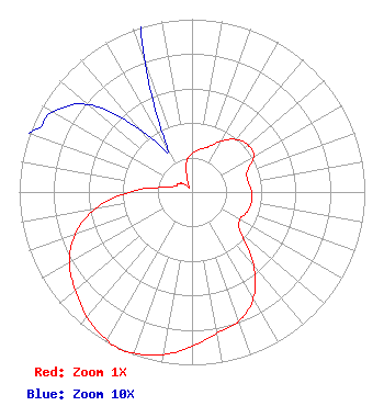 | ||||||||||||||||||
| Azimuth | Ratio | Azimuth | Ratio | Azimuth | Ratio | Azimuth | Ratio | ||||||||||||
| 0 | 0.223 | 10 | 0.251 | 20 | 0.278 | 30 | 0.341 | ||||||||||||
| 40 | 0.397 | 50 | 0.423 | 60 | 0.413 | 70 | 0.339 | ||||||||||||
| 80 | 0.331 | 90 | 0.346 | 100 | 0.349 | 110 | 0.338 | ||||||||||||
| 120 | 0.319 | 130 | 0.368 | 140 | 0.555 | 150 | 0.710 | ||||||||||||
| 160 | 0.795 | 170 | 0.831 | 180 | 0.893 | 190 | 0.956 | ||||||||||||
| 200 | 0.992 | 204 | 1.000 | 210 | 0.988 | 220 | 0.945 | ||||||||||||
| 230 | 0.883 | 240 | 0.820 | 250 | 0.722 | 260 | 0.570 | ||||||||||||
| 270 | 0.364 | 280 | 0.156 | 290 | 0.102 | 300 | 0.093 | ||||||||||||
| 310 | 0.079 | 320 | 0.048 | 330 | 0.028 | 340 | 0.079 | ||||||||||||
| 350 | 0.180 | ||||||||||||||||||
Structure Registration Number 1027163 Structure Type: GTOWER Registered To: Subcarrier Communications, Inc. Structure Address: Bald Mountain Ransom Twp Scranton, PA County Name: Lackawanna County ASR Issued: 01/17/2018 Date Built: 01/01/1988 Site Elevation: 672.1 m (2205 ft.) Structure Height: 158.3 m (519 ft.) Height Overall: 159.5 m (523 ft.) Overall Height AMSL: 831.6 m (2728 ft.) FAA Determination: 06/05/2017 FAA Study #: 2017-AEA-5892-OE FAA Circular #: 70/7460-1L Paint & Light FAA Chapters: 3, 4, 5, 12 PRIOR STUDY 1988-AEA-1036-OE 41-25-36.0 N 75-44-51.0 W (NAD 83) 41-25-35.7 N 75-44-52.3 W (Converted to NAD 27) |
P.o. Box 851 Pittston, PA 18640 Phone: 570-287-4670 Not-for-Profit | Title: General Partner Date: 02/07/2023 Application Certifier GEOS COMMUNICATIONS Geos Communications 54 Wilmar Drive P.o. Box 701 Tunkhannock, PA 18657 Applicant Kevin M Fitzgerald Kevin Fitzgerald Engineering P.o. Box 20155 Scranton, PA 18502 CHIEF ENGINEER AND GENERAL PARTNER Kevin M Fitzgerald Kevin Fitzgerald Engineering P.o. Box 20155 Scranton, PA 18502 General Partner | |||||||||||||||||