
FCCInfo.com
A Service of Cavell, Mertz & Associates, Inc.
(855) FCC-INFO
|
|
|
|
|
||||||||||||||||
|
|
W264CU Channel: 264D 100.7 MHz Winston-salem, North Carolina Service: FX - A translator or application for a translator. Facility ID: 157988 Fac. Service: FX Programming Delivery Method: Unspecified Status: Construction Permit Application Accepted: 05/08/2023 Application Granted: 05/24/2023 File Number: -0000214587 W264CU CP Expires: 05/23/2026 Application Type: Minor Modification FCC Website Links: LMS Facility Details This Application Other W264CU Applications Other W264CU Applications in CDBS Including Superseded Applications Mailing Address Correspondence for W264CU Correspondence related to application -0000214587 Service Contour - Open Street Map or USGS Map (60 dBu) Service Contour - KML / Google Earth (60 dBu) Facility Type: FM STATION Class: D, A Noncommercial educational operating with no more than 10W Site Location: 35-49-59.7 N 80-42-14.0 W (NAD 83) Site Location: 35-49-59.2 N 80-42-14.8 W (Converted to NAD 27) Effective Radiated Power: 0.25 kW Antenna Center HAAT: 0 m Antenna Center AMSL: 627.3 m (2058 ft.) Antenna Center HAG: 378 m (1240 ft.) Site Elevation: 249.3 m. (818 ft.) Height Overall*: 458.7 m (1505 ft.) (* As Filed In This Application, may differ from ASR Data, Below.) Directional Antenna Antenna Make/Model: Propagation System Inc FML-1-DA Antenna ID: 134073 Polarization: H
| ||||||||||||||||||
| Antenna Data for Antenna Id: 134073 W264CU FX File: -0000214587 Propagation System Inc - FML-1-DA Service: FX | 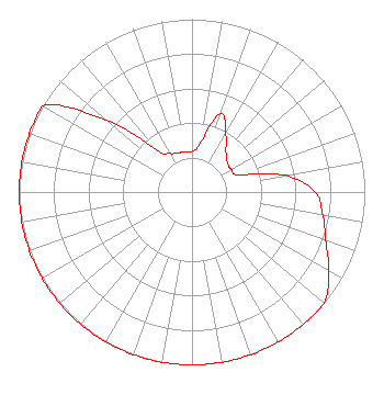 | ||||||||||||||||||
| Azimuth | Ratio | Azimuth | Ratio | Azimuth | Ratio | Azimuth | Ratio | ||||||||||||
| 0 | 0.236 | 10 | 0.284 | 20 | 0.481 | 30 | 0.390 | ||||||||||||
| 40 | 0.306 | 50 | 0.268 | 60 | 0.262 | 70 | 0.291 | ||||||||||||
| 80 | 0.550 | 90 | 0.713 | 100 | 0.769 | 110 | 0.824 | ||||||||||||
| 120 | 0.914 | 130 | 1.000 | 140 | 1.000 | 150 | 1.000 | ||||||||||||
| 160 | 1.000 | 170 | 1.000 | 180 | 1.000 | 190 | 1.000 | ||||||||||||
| 200 | 1.000 | 210 | 1.000 | 220 | 1.000 | 230 | 1.000 | ||||||||||||
| 240 | 1.000 | 250 | 1.000 | 260 | 1.000 | 270 | 1.000 | ||||||||||||
| 280 | 1.000 | 290 | 1.000 | 300 | 1.000 | 310 | 0.647 | ||||||||||||
| 320 | 0.318 | 330 | 0.258 | 340 | 0.240 | 350 | 0.238 | ||||||||||||
Structure Registration Number 1008245 Structure Type: GTOWER Registered To: American Towers LLC Structure Address: Cool Springs Rd. ( Site # 311111) Cleveland, NC County Name: Rowan County ASR Issued: 09/04/2020 Date Built: 04/06/1988 Site Elevation: 249.3 m (818 ft.) Structure Height: 457.2 m (1500 ft.) Height Overall: 458.7 m (1505 ft.) Overall Height AMSL: 708 m (2323 ft.) FAA Determination: 06/23/2020 FAA Study #: 2019-ASO-37577-OE FAA Circular #: 70/7460-1L Paint & Light FAA Chapters: 4, 9, 12 PRIOR STUDY 2012-ASO-4422-OE 35-49-59.7 N 80-42-14.0 W (NAD 83) 35-49-59.2 N 80-42-14.8 W (Converted to NAD 27) |
18067 W. Catawba Ave. Ste. 204 Cornelius, NC 28031 Phone: 833-696-2737 Limited Liability Company | Title: President Date: 05/08/2023 Application Certifier IREDELL BROADCASTING, INC. Iredell Broadcasting, Inc. 1117 Radio Road Statesville, NC 28677 Applicant Timothy G Nelson Brooks, Pierce Et. Al. 150 Fayetteville Street Suite 1700 Raleigh, NC 27601 Gene Wisniewski Genew2012 1472 E 3100 S Wendell, ID 83355 CONSULTING ENGINEER | |||||||||||||||||