
FCCInfo.com
A Service of Cavell, Mertz & Associates, Inc.
(855) FCC-INFO
|
|
WDRQ from 08/10/1996 WDRQ from 04/15/1985 WDRQ from 06/25/1980 |
|  |
|
|||||||||||||||
|
|
WUFL Channel: 226B 93.1 MHz Detroit, Michigan Service: FM - A full-service FM station or application. Facility ID: 70040 Fac. Service: FM Analog & Digital Status: License Application Accepted: 06/23/2023 Application Granted: 09/06/2023 File Number: -0000217091 License Expires: 10/01/2028 Application Type: Minor Modification FCC Website Links: LMS Facility Details This Application Other WUFL Applications Other WUFL Applications in CDBS Including Superseded Applications Mailing Address Correspondence for WUFL Correspondence related to application -0000217091 Service Contour - Open Street Map or USGS Map (54 dBu) Service Contour - KML / Google Earth (54 dBu) Public Inspection Files History Cards for WUFL Facility Type: NON-COMMERCIAL EDUC. FM Class: B, A Zone I or I-A station; with 25kW-50kW ERP and a class contour distance 39km-52km Site Location: 42-28-16.1 N 83-12-01.0 W (NAD 83) Site Location: 42-28-16.0 N 83-12-01.3 W (Converted to NAD 27) Effective Radiated Power: 26.5 kW Antenna Center HAAT: 204 m (669 ft.) Antenna Center AMSL: 412 m (1352 ft.) Antenna Center HAG: 206 m (676 ft.) Site Elevation: 206 m. (676 ft.) Height Overall*: 244 m (801 ft.) (* As Filed In This Application, may differ from ASR Data, Below.) Directional Antenna Antenna Make/Model: Alan Dick Spearhead Panel,2 sections Antenna ID: 13705 Polarization: H | ||||||||||||||||||
| Antenna Data for Antenna Id: 13705 WUFL FM File: -0000217091 Alan Dick - Spearhead Panel,2 sections Service: FM | 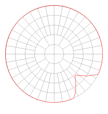 | ||||||||||||||||||
| Azimuth | Ratio | Azimuth | Ratio | Azimuth | Ratio | Azimuth | Ratio | ||||||||||||
| 0 | 1.000 | 10 | 1.000 | 20 | 1.000 | 30 | 1.000 | ||||||||||||
| 40 | 1.000 | 50 | 1.000 | 60 | 1.000 | 70 | 1.000 | ||||||||||||
| 80 | 1.000 | 90 | 1.000 | 100 | 1.000 | 110 | 1.000 | ||||||||||||
| 114 | 1.000 | 120 | 0.880 | 130 | 0.700 | 135 | 0.620 | ||||||||||||
| 140 | 0.690 | 150 | 0.880 | 157 | 1.000 | 160 | 1.000 | ||||||||||||
| 170 | 1.000 | 180 | 1.000 | 190 | 1.000 | 200 | 1.000 | ||||||||||||
| 210 | 1.000 | 220 | 1.000 | 230 | 1.000 | 240 | 1.000 | ||||||||||||
| 250 | 1.000 | 260 | 1.000 | 270 | 1.000 | 280 | 1.000 | ||||||||||||
| 290 | 1.000 | 300 | 1.000 | 310 | 1.000 | 320 | 1.000 | ||||||||||||
| 330 | 1.000 | 340 | 1.000 | 350 | 1.000 | ||||||||||||||
Structure Registration Number 1002474 Structure Type: GTOWER Registered To: American Towers LLC Structure Address: 24600 Greenfield Road (# 372319) Oak Park, MI County Name: Oakland County ASR Issued: 12/02/2022 Date Built: 11/11/2006 Site Elevation: 206 m (676 ft.) Structure Height: 216.4 m (710 ft.) Height Overall: 243.8 m (800 ft.) Overall Height AMSL: 449.8 m (1476 ft.) FAA Determination: 11/01/2022 FAA Study #: 2022-AGL-5843-OE FAA Circular #: 70/7460-1K Paint & Light FAA Chapters: 3, 4, 5, 12 PRIOR STUDIES 2010-AGL-7402-OE / 2018-AGL-4515-OE 42-28-16.1 N 83-12-01.0 W (NAD 83) 42-28-16.0 N 83-12-01.3 W (Converted to NAD 27) |
7355 N. Oracle Road Tucson, AZ 85704 Phone: 520-219-7708 Not-for-Profit | Title: Chief Broadcast Systems Officer Date: 06/23/2023 Application Certifier RADIO LICENSE HOLDINGS LLC Family Life Broadcasting System 7355 N. Oracle Road Tucson, AZ 85704 Applicant Joseph C Chautin, III Hardy, Carey, Chautin & Balkin, Llp 1080 West Causeway Approach Mandeville, LA 70471 Attorney-At-Law Amy G. Rollins Family Life Broadcasting System 7355 N. Oracle Road Tucson, AZ 85704 Compliance Officer | |||||||||||||||||
| |||||||||||||||||||