
FCCInfo.com
A Service of Cavell, Mertz & Associates, Inc.
(855) FCC-INFO
|
|
WMXD from 12/28/1987 WMXD from 05/15/1986 |
|
|
||||||||||||||||
|
|
WMXD Channel: 222B 92.3 MHz Detroit, Michigan Service: FS - A full service FM station auxiliary transmitting antenna or application. Facility ID: 59596 Fac. Service: FM Analog & Digital Status: License 73.215 Station Application Accepted: 08/17/2023 Application Pending: 08/18/2023 File Number: -0000219548 License Expires: 07/06/2024 Application Type: License To Cover FCC Website Links: LMS Facility Details This Application Other WMXD Applications Other WMXD Applications in CDBS Including Superseded Applications Mailing Address Correspondence for WMXD Correspondence related to application -0000219548 Service Contour - Open Street Map or USGS Map (54 dBu) Service Contour - KML / Google Earth (54 dBu) Public Inspection Files History Cards for WMXD Facility Type: FM STATION Class: B, A Zone I or I-A station; with 25kW-50kW ERP and a class contour distance 39km-52km Site Location: 42-21-06.0 N 83-03-48.0 W (NAD 83) Site Location: 42-21-05.9 N 83-03-48.3 W (Converted to NAD 27) Effective Radiated Power: 41 kW Antenna Center HAAT: 135 m (443 ft.) Antenna Center AMSL: 320 m (1050 ft.) Antenna Center HAG: 129.5 m (425 ft.) Site Elevation: 190.5 m. (625 ft.) Height Overall*: 172.5 m (566 ft.) (* As Filed In This Application, may differ from ASR Data, Below.) Directional Antenna Antenna Make/Model: Electronics Research Inc. MP-4E-DA Antenna ID: 1011006 Polarization: | ||||||||||||||||||
| Antenna Data for Antenna Id: 1011006 WMXD FS File: -0000219548 Electronics Research Inc. - MP-4E-DA Service: FS | 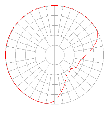 | ||||||||||||||||||
| Azimuth | Ratio | Azimuth | Ratio | Azimuth | Ratio | Azimuth | Ratio | ||||||||||||
| 0 | 1.000 | 10 | 1.000 | 20 | 1.000 | 30 | 1.000 | ||||||||||||
| 40 | 1.000 | 50 | 1.000 | 60 | 1.000 | 70 | 0.920 | ||||||||||||
| 80 | 0.788 | 90 | 0.651 | 100 | 0.552 | 110 | 0.521 | ||||||||||||
| 120 | 0.509 | 130 | 0.439 | 140 | 0.462 | 150 | 0.488 | ||||||||||||
| 160 | 0.614 | 170 | 0.772 | 180 | 0.929 | 190 | 1.000 | ||||||||||||
| 200 | 1.000 | 210 | 1.000 | 220 | 1.000 | 230 | 1.000 | ||||||||||||
| 240 | 1.000 | 250 | 1.000 | 260 | 1.000 | 270 | 1.000 | ||||||||||||
| 280 | 1.000 | 290 | 1.000 | 300 | 1.000 | 310 | 1.000 | ||||||||||||
| 320 | 1.000 | 330 | 1.000 | 340 | 1.000 | 350 | 1.000 | ||||||||||||
Structure Registration Number 1007201 Structure Type: TOWER Registered To: WAYNE STATE UNIVERSITY Structure Address: 105 W Canfield Detroit, MI County Name: Wayne County ASR Issued: 01/25/1997 Date Built: 01/22/1996 Site Elevation: 190.5 m (625 ft.) Structure Height: 171.3 m (562 ft.) Height Overall: 172.5 m (566 ft.) Overall Height AMSL: 363 m (1191 ft.) FAA Determination: 10/13/1995 FAA Study #: 95-AGL-2069-OE FAA Circular #: 70/7460-1H Paint & Light FAA Chapters: 4, 9, 13 42-21-06.0 N 83-03-48.0 W (NAD 83) 42-21-05.9 N 83-03-48.3 W (Converted to NAD 27) |
7136 S. Yale Avenue Suite 501 Tulsa, OK 74136 Phone: 918-664-4581 Limited Liability Company | Title: Vp, Technical Regulatory Affairs Date: 08/17/2023 Application Certifier IHM LICENSES, LLC Ihm Licenses, Llc 7136 S. Yale Avenue Suite 501 Tulsa, OK 74136 Applicant Troy Langham Ihm Licenses, Llc 7136 S. Yale Avenue Suite 501 Tulsa, OK 74136 VP, Technical Regulatory Affairs | |||||||||||||||||