
FCCInfo.com
A Service of Cavell, Mertz & Associates, Inc.
(855) FCC-INFO
|
|
W263CY from 03/02/2005 |
|
|
||||||||||||||||
|
|
W263CY Channel: 263D 100.5 MHz Charlotte, North Carolina Service: FX - A translator or application for a translator. Facility ID: 156532 Fac. Service: FX Programming Delivery Method: Unspecified Status: License Application Accepted: 10/31/2019 Application Granted: 02/05/2020 File Number: -0000087752 License Expires: 12/01/2027 Application Type: License To Cover FCC Website Links: LMS Facility Details This Application Other W263CY Applications Other W263CY Applications in CDBS Including Superseded Applications Mailing Address Correspondence for W263CY Correspondence related to application -0000087752 Service Contour - Open Street Map or USGS Map (60 dBu) Service Contour - KML / Google Earth (60 dBu) Facility Type: FM STATION Class: D, A Noncommercial educational operating with no more than 10W Site Location: 35-15-05.5 N 80-41-11.2 W (NAD 83) Site Location: 35-15-05.0 N 80-41-12.0 W (Converted to NAD 27) Effective Radiated Power: 0.25 kW Horiz. ; 0 kW Vert. Antenna Center HAAT: 0 m Antenna Center AMSL: 359 m Horiz.; 0 m Vert. Antenna Center HAG: 162 m Horiz.; 0 m Vert. Site Elevation: 197 m. (646 ft.) Height Overall*: 180 m (591 ft.) (* As Filed In This Application, may differ from ASR Data, Below.) Directional Antenna Antenna Make/Model: Kathrein Two CL-FM Antennas Oriented at 58 and 342 Degrees Antenna ID: 135015 Polarization: H
| ||||||||||||||||||
| Antenna Data for Antenna Id: 135015 W263CY FX File: -0000087752 Kathrein - Two CL-FM Antennas Oriented at 58 and 342 Degrees Service: FX | 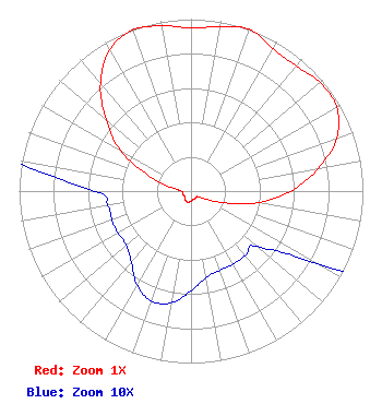 | ||||||||||||||||||
| Azimuth | Ratio | Azimuth | Ratio | Azimuth | Ratio | Azimuth | Ratio | ||||||||||||
| 0 | 0.948 | 10 | 0.969 | 20 | 1.000 | 30 | 0.954 | ||||||||||||
| 40 | 0.952 | 50 | 0.980 | 60 | 0.980 | 70 | 0.903 | ||||||||||||
| 80 | 0.751 | 90 | 0.581 | 100 | 0.392 | 110 | 0.196 | ||||||||||||
| 120 | 0.085 | 130 | 0.050 | 140 | 0.049 | 150 | 0.049 | ||||||||||||
| 160 | 0.049 | 170 | 0.051 | 180 | 0.058 | 190 | 0.066 | ||||||||||||
| 200 | 0.068 | 210 | 0.063 | 220 | 0.054 | 230 | 0.049 | ||||||||||||
| 240 | 0.049 | 250 | 0.049 | 260 | 0.049 | 270 | 0.056 | ||||||||||||
| 280 | 0.113 | 290 | 0.267 | 300 | 0.476 | 310 | 0.646 | ||||||||||||
| 320 | 0.819 | 330 | 0.947 | 340 | 0.996 | 350 | 0.976 | ||||||||||||
Structure Registration Number 1216075 Structure Type: TOWER Registered To: American Towers, LLC Structure Address: 8040 Hood Road (#306397) Harrisburg, NC County Name: Mecklenburg County ASR Issued: 02/07/2020 Date Built: 05/19/2008 Site Elevation: 196.9 m (646 ft.) Structure Height: 178.3 m (585 ft.) Height Overall: 179.8 m (590 ft.) Overall Height AMSL: 376.7 m (1236 ft.) FAA Determination: 08/13/2007 FAA Study #: 2007-ASO-4011-OE Paint & Light FAA Chapters: NONE PRIOR STUDY 2007-ASO-2937-OE 35-15-05.5 N 80-41-11.2 W (NAD 83) 35-15-05.0 N 80-41-12.0 W (Converted to NAD 27) |
P.o. Box 861 Rock Hill, SC 29731 Phone: 803-329-8652 Limited Liability Company | Title: Manager Date: 10/31/2019 Application Certifier RFPJY, LLC Rfpjy, Llc Pineville, NC 28134 Applicant David Tillotson Law Office Of David Tillotson 4606 Charleston Terrace, Nw Washington, DC 20007-1911 George S Crissey Bromo Communications, Inc. 3600 Dallas Highway, Suite 230 - Pmb 164 Marietta, GA 30064 TECHNICAL CONSULTANT | |||||||||||||||||