
FCCInfo.com
A Service of Cavell, Mertz & Associates, Inc.
(855) FCC-INFO
|
|
W226CT from 11/05/2013 |
|
|
||||||||||||||||
|
|
W226CT Channel: 226D 93.1 MHz Leeds, Alabama Service: FX - A translator or application for a translator. Facility ID: 141696 Fac. Service: FX Programming Delivery Method: Unspecified Status: License Application Accepted: 11/15/2021 Application Granted: 12/09/2021 File Number: -0000168811 License Expires: 04/01/2028 Application Type: License To Cover FCC Website Links: LMS Facility Details This Application Other W226CT Applications Other W226CT Applications in CDBS Including Superseded Applications Mailing Address Correspondence for W226CT Correspondence related to application -0000168811 Service Contour - Open Street Map or USGS Map (60 dBu) Service Contour - KML / Google Earth (60 dBu) Facility Type: NON-COMMERCIAL EDUC. FM Class: D, A Noncommercial educational operating with no more than 10W Site Location: 33-23-51.4 N 86-39-40.9 W (NAD 83) Site Location: 33-23-51.0 N 86-39-41.0 W (Converted to NAD 27) Effective Radiated Power: 0.099 kW Transmitter Output Power: 0.02 kW Antenna Center HAAT: 115.4 m Horiz.; 0 m Vert. Antenna Center AMSL: 433.7 m (1423 ft.) Antenna Center HAG: 74 m (243 ft.) Site Elevation: 359.7 m. (1180 ft.) Height Overall*: 85.3 m (280 ft.) (* As Filed In This Application, may differ from ASR Data, Below.) Directional Antenna Antenna Make/Model: Nicom BKY-3P Antenna ID: 116213 Polarization: H
| ||||||||||||||||||
| Antenna Data for Antenna Id: 116213 W226CT FX File: -0000168811 Nicom - BKY-3P Service: FX | 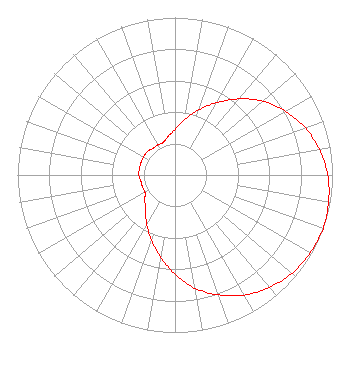 | ||||||||||||||||||
| Azimuth | Ratio | Azimuth | Ratio | Azimuth | Ratio | Azimuth | Ratio | ||||||||||||
| 0 | 0.290 | 10 | 0.360 | 20 | 0.440 | 30 | 0.530 | ||||||||||||
| 40 | 0.630 | 50 | 0.730 | 60 | 0.810 | 70 | 0.880 | ||||||||||||
| 80 | 0.930 | 90 | 0.970 | 100 | 0.990 | 110 | 1.000 | ||||||||||||
| 120 | 0.990 | 130 | 0.970 | 140 | 0.930 | 150 | 0.880 | ||||||||||||
| 160 | 0.810 | 170 | 0.730 | 180 | 0.630 | 190 | 0.530 | ||||||||||||
| 200 | 0.440 | 210 | 0.360 | 220 | 0.290 | 230 | 0.250 | ||||||||||||
| 240 | 0.220 | 250 | 0.220 | 260 | 0.220 | 270 | 0.230 | ||||||||||||
| 280 | 0.230 | 290 | 0.230 | 300 | 0.230 | 310 | 0.230 | ||||||||||||
| 320 | 0.220 | 330 | 0.220 | 340 | 0.220 | 350 | 0.250 | ||||||||||||
Structure Registration Number 1036727 Structure Type: TOWER Registered To: Pinnacle Towers LLC Structure Address: 673 Crest Rd. Birmingham, AL County Name: Shelby County ASR Issued: 05/06/2016 Date Built: 05/05/1997 Site Elevation: 359.7 m (1180 ft.) Structure Height: 76.2 m (250 ft.) Height Overall: 85.3 m (280 ft.) Overall Height AMSL: 445 m (1460 ft.) FAA Determination: 02/04/2004 FAA Study #: 2004-ASO-360-OE FAA Circular #: 70/7460-1K Paint & Light FAA Chapters: 4, 8, 12 PRIOR STUDY 1996-ASO-4629-OE 33-23-51.4 N 86-39-40.9 W (NAD 83) 33-23-51.0 N 86-39-41.0 W (Converted to NAD 27) Crown Castle 1036727 - Pinnacle Towers LLC |
2052 Oak Mountain Drive Pelham, AL 35124 Phone: 205-358-1100 Limited Liability Company | Title: Manager Date: 11/15/2021 Application Certifier AVONDALE METAL WORKS, LLC Avondale Metal Works, Llc 41 Fox Fire Circle Indian Springs Village, AL 35124 Applicant John Mathews John Matthews 1823 Thornton Place Hoover, AL 35226 CONSULTING ENGINEER | |||||||||||||||||