
FCCInfo.com
A Service of Cavell, Mertz & Associates, Inc.
(855) FCC-INFO
|
|
W285ER from 10/02/1997 |
|
|
||||||||||||||||
|
|
W285ER Channel: 285D 104.9 MHz Prospect, Kentucky Service: FX - A translator or application for a translator. Facility ID: 86302 Fac. Service: FX Programming Delivery Method: Unspecified Status: License Application Accepted: 04/06/2022 Application Granted: 04/14/2022 File Number: -0000188968 License Expires: 08/01/2020 Application Type: License To Cover FCC Website Links: LMS Facility Details This Application Other W285ER Applications Other W285ER Applications in CDBS Including Superseded Applications Mailing Address Correspondence for W285ER Correspondence related to application -0000188968 Service Contour - Open Street Map or USGS Map (60 dBu) Service Contour - KML / Google Earth (60 dBu) Facility Type: FM STATION Class: D, A Noncommercial educational operating with no more than 10W Site Location: 38-23-47.0 N 85-35-17.3 W (NAD 83) Site Location: 38-23-46.8 N 85-35-17.4 W (Converted to NAD 27) Effective Radiated Power: 0.25 kW Transmitter Output Power: 0.055 kW Antenna Center HAAT: 56 m Horiz.; 0 m Vert. Antenna Center AMSL: 269.2 m (883 ft.) Antenna Center HAG: 58 m (190 ft.) Site Elevation: 211.2 m. (693 ft.) Height Overall*: 83.8 m (275 ft.) (* As Filed In This Application, may differ from ASR Data, Below.) Directional Antenna Antenna Make/Model: Propagation System Inc FML-2DA Antenna ID: 16150 Polarization: H
| ||||||||||||||||||
| Antenna Data for Antenna Id: 16150 W285ER FX File: -0000188968 Propagation System Inc - FML-2DA Service: FX | 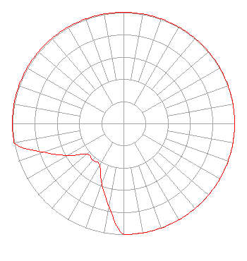 | ||||||||||||||||||
| Azimuth | Ratio | Azimuth | Ratio | Azimuth | Ratio | Azimuth | Ratio | ||||||||||||
| 0 | 1.000 | 10 | 1.000 | 20 | 1.000 | 30 | 1.000 | ||||||||||||
| 40 | 1.000 | 50 | 1.000 | 60 | 1.000 | 70 | 1.000 | ||||||||||||
| 80 | 1.000 | 90 | 1.000 | 100 | 1.000 | 110 | 1.000 | ||||||||||||
| 120 | 1.000 | 130 | 1.000 | 140 | 1.000 | 150 | 1.000 | ||||||||||||
| 160 | 1.000 | 170 | 1.000 | 180 | 1.000 | 190 | 0.760 | ||||||||||||
| 200 | 0.575 | 210 | 0.430 | 220 | 0.430 | 230 | 0.430 | ||||||||||||
| 240 | 0.575 | 250 | 0.760 | 260 | 1.000 | 270 | 1.000 | ||||||||||||
| 280 | 1.000 | 290 | 1.000 | 300 | 1.000 | 310 | 1.000 | ||||||||||||
| 320 | 1.000 | 330 | 1.000 | 340 | 1.000 | 350 | 1.000 | ||||||||||||
Structure Registration Number 1264505 [ASR Heights Differ from W285ER Application] Structure Type: LTOWER Registered To: T-Mobile South LLC Structure Address: 1721 South Highway 1793 (9lv1087a) Goshen, KY County Name: Oldham County ASR Issued: 10/30/2023 Date Built: 06/12/2015 Site Elevation: 211.2 m (693 ft.) Structure Height: 78.6 m (258 ft.) Height Overall: 78.6 m (258 ft.) Overall Height AMSL: 289.8 m (951 ft.) FAA Determination: 09/11/2008 FAA Study #: 2008-ASO-4642-OE FAA Circular #: 70/7460-1K Paint & Light FAA Chapters: 4, 8, 12 PRIOR STUDY 2007-ASO-3178-OE 38-23-47.0 N 85-35-17.3 W (NAD 83) 38-23-46.8 N 85-35-17.4 W (Converted to NAD 27) |
P.o. Box 2087 Elizabethtown, KY 42702 Phone: 270-766-1035 Corporation | Title: President Date: 04/06/2022 Application Certifier W & B BROADCASTING CO., INC. W & B Broadcasting Co., Inc. P.o. Box 2087 Elizabethtown, KY 42702 Applicant CHARLES M. ANDERSON, Anderson Charles M. Anerson Associates 5900 Lake Cyrus Dr. H, AL 35244 BROADCAST ENGINEERING CONSULTANT JOHN NEELY,, ESQ. . 4 Simms Court Kensington, MD 20895 | |||||||||||||||||