
FCCInfo.com
A Service of Cavell, Mertz & Associates, Inc.
(855) FCC-INFO
|
|
WLRB from 07/01/2010 WLRB from 11/08/1994 WLRB from 06/28/1991 |
|
|
||||||||||||||||
|
|
WLRB Channel: 274A 102.7 MHz Ocean City, New Jersey Service: FM - A full-service FM station or application. Facility ID: 51575 Fac. Service: FM Status: License 73.215 Station Application Accepted: 10/20/2022 Application Granted: 11/04/2022 File Number: -0000202711 License Expires: 06/01/2030 Application Type: Minor Modification FCC Website Links: LMS Facility Details This Application Other WLRB Applications Other WLRB Applications in CDBS Including Superseded Applications Mailing Address Correspondence for WLRB Correspondence related to application -0000202711 Service Contour - Open Street Map or USGS Map (60 dBu) Service Contour - KML / Google Earth (60 dBu) Public Inspection Files Facility Type: NON-COMMERCIAL EDUC. FM Class: A, A Zone I; I-A; or II station; with 0.1kW-6kW ERP and a class contour distance <=28km Site Location: 39-21-04.4 N 74-26-52.5 W (NAD 83) Site Location: 39-21-04.0 N 74-26-54.0 W (Converted to NAD 27) Effective Radiated Power: 4.1 kW Transmitter Output Power: 3.7 kW Antenna Center HAAT: 121.7 m (399 ft.) Antenna Center AMSL: 122.8 m (403 ft.) Antenna Center HAG: 120.4 m (395 ft.) Site Elevation: 2.4 m. (8 ft.) Height Overall*: 122 m (400 ft.) (* As Filed In This Application, may differ from ASR Data, Below.) Directional Antenna Antenna Make/Model: Shivley 6810-2R-SS-DA, 2 sections, 0.5 wavelength spaced Antenna ID: 97322 Polarization: | ||||||||||||||||||
| Antenna Data for Antenna Id: 97322 WLRB FM File: -0000202711 Shivley - 6810-2R-SS-DA, 2 sections, 0.5 wavelength spaced Service: FM | 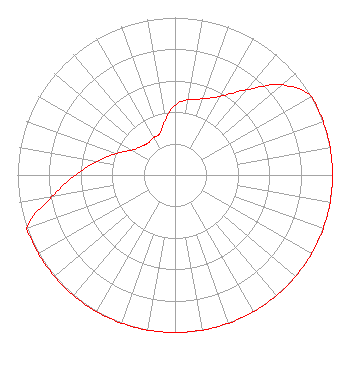 | ||||||||||||||||||
| Azimuth | Ratio | Azimuth | Ratio | Azimuth | Ratio | Azimuth | Ratio | ||||||||||||
| 0 | 0.444 | 10 | 0.486 | 20 | 0.515 | 30 | 0.578 | ||||||||||||
| 40 | 0.707 | 50 | 0.889 | 60 | 1.000 | 70 | 1.000 | ||||||||||||
| 80 | 1.000 | 90 | 1.000 | 100 | 1.000 | 110 | 1.000 | ||||||||||||
| 120 | 1.000 | 130 | 1.000 | 140 | 1.000 | 150 | 1.000 | ||||||||||||
| 160 | 1.000 | 170 | 1.000 | 180 | 1.000 | 190 | 1.000 | ||||||||||||
| 200 | 1.000 | 210 | 1.000 | 220 | 1.000 | 230 | 1.000 | ||||||||||||
| 240 | 1.000 | 250 | 1.000 | 260 | 0.794 | 270 | 0.631 | ||||||||||||
| 280 | 0.501 | 290 | 0.398 | 300 | 0.317 | 310 | 0.281 | ||||||||||||
| 320 | 0.266 | 330 | 0.273 | 340 | 0.281 | 350 | 0.353 | ||||||||||||
Structure Registration Number 1272259 Structure Type: TOWER Registered To: OCEAN CLUB CONDOMINIUM ASSOCIATION Structure Address: 3101 Boardwalk, Atlantic City, Nj Atlantic City, NJ County Name: Atlantic County ASR Issued: 01/08/2018 Date Built: 12/27/2010 Site Elevation: 2.4 m (8 ft.) Structure Height: 110 m (361 ft.) Height Overall: 122 m (400 ft.) Overall Height AMSL: 124.4 m (408 ft.) FAA Determination: 12/10/2009 FAA Study #: 2009-AEA-3278-OE FAA Circular #: 70/7460-1K Paint & Light FAA Chapters: 4, 5, 12 Removed expiration date from determination. Scenario 1./jjs/case#635066 39-21-04.0 N 74-26-52.5 W (NAD 83) 39-21-03.6 N 74-26-54.0 W (Converted to NAD 27) |
5700 West Oaks Boulevard Rocklin, CA 95765 Phone: 916-251-1600 Not-for-Profit | Title: Ceo Date: 10/20/2022 Application Certifier EDUCATIONAL MEDIA FOUNDATION Educational Media Foundation 5700 West Oaks Boulevard Rocklin, CA 95765 Applicant MARY O'CONNOR Wilkinson Barker Knauer, Llp 1800 M Street, N.w., Suite 800n Washington, DC 20036 JAMES TRAVIS Educational Media Foundation 5700 West Oaks Blvd. Rocklin, CA 95765 FCC COMPLIANCE ENGINEER | |||||||||||||||||