
FCCInfo.com
A Service of Cavell, Mertz & Associates, Inc.
(855) FCC-INFO
|
|
W280EC from 06/02/2004 |
|
|
||||||||||||||||
|
|
W280EC Channel: 280D 103.9 MHz Concord, New Hampshire Service: FX - A translator or application for a translator. Facility ID: 145612 Fac. Service: FX Programming Delivery Method: Unspecified Status: License Application Accepted: 01/17/2024 Application Granted: 01/25/2024 File Number: -0000235595 License Expires: 04/01/2030 Application Type: License To Cover FCC Website Links: LMS Facility Details This Application Other W280EC Applications Other W280EC Applications in CDBS Including Superseded Applications Mailing Address Correspondence for W280EC Correspondence related to application -0000235595 Service Contour - Open Street Map or USGS Map (60 dBu) Service Contour - KML / Google Earth (60 dBu) Facility Type: FM STATION Class: D, A Noncommercial educational operating with no more than 10W Site Location: 43-11-41.0 N 71-33-18.0 W (NAD 83) Site Location: 43-11-40.7 N 71-33-19.7 W (Converted to NAD 27) Effective Radiated Power: 0.038 kW Transmitter Output Power: 0.005 kW Antenna Center HAAT: 162.8 m Horiz.; 0 m Vert. Antenna Center AMSL: 176.7 m (580 ft.) Antenna Center HAG: 85.3 m (280 ft.) Site Elevation: 91.4 m. (300 ft.) Height Overall*: 94.5 m (310 ft.) (* As Filed In This Application, may differ from ASR Data, Below.) Directional Antenna Antenna Make/Model: Nicom BKG77 Antenna ID: 91203 Polarization: H
| ||||||||||||||||||
| Antenna Data for Antenna Id: 91203 W280EC FX File: -0000235595 Nicom - BKG77 Service: FX | 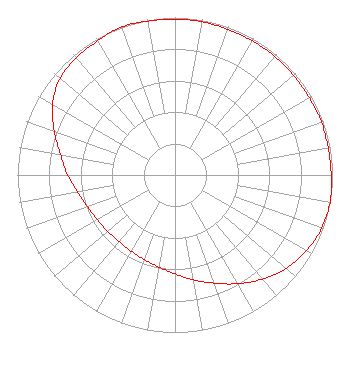 | ||||||||||||||||||
| Azimuth | Ratio | Azimuth | Ratio | Azimuth | Ratio | Azimuth | Ratio | ||||||||||||
| 0 | 0.988 | 10 | 0.988 | 20 | 0.983 | 30 | 0.983 | ||||||||||||
| 40 | 0.983 | 50 | 0.983 | 60 | 0.983 | 70 | 0.988 | ||||||||||||
| 80 | 0.988 | 90 | 0.992 | 100 | 1.000 | 110 | 0.991 | ||||||||||||
| 120 | 0.963 | 130 | 0.923 | 140 | 0.862 | 150 | 0.797 | ||||||||||||
| 160 | 0.731 | 170 | 0.676 | 180 | 0.628 | 190 | 0.594 | ||||||||||||
| 200 | 0.571 | 210 | 0.558 | 220 | 0.553 | 230 | 0.558 | ||||||||||||
| 240 | 0.571 | 250 | 0.594 | 260 | 0.628 | 270 | 0.682 | ||||||||||||
| 280 | 0.738 | 290 | 0.815 | 300 | 0.897 | 310 | 0.953 | ||||||||||||
| 320 | 0.973 | 330 | 0.983 | 340 | 1.000 | 350 | 0.992 | ||||||||||||
Structure Registration Number 1034646 Structure Type: GTOWER Registered To: New Hampshire Family Radio LLC Structure Address: 37 Redington Rd Concord, NH County Name: Merrimack County ASR Issued: 04/25/2023 Date Built: 01/01/1946 Site Elevation: 91.4 m (300 ft.) Structure Height: 93.6 m (307 ft.) Height Overall: 94.5 m (310 ft.) Overall Height AMSL: 185.9 m (610 ft.) FAA Determination: 07/23/2010 FAA Study #: 2010-ANE-376-OE FAA Circular #: 70/7460-1K Paint & Light FAA Chapters: 3, 4, 5, 12 Continue As Is OM&L = PAINT/RED LIGHTS 43-11-41.0 N 71-33-18.0 W (NAD 83) 43-11-40.7 N 71-33-19.7 W (Converted to NAD 27) |
P.o. Box 2108 Concord, NH 03302 Phone: 603-225-5521 Limited Liability Company | Title: Sole Member Date: 01/17/2024 Application Certifier NEW HAMPSHIRE FAMILY RADIO, LLC New Hampshire Family Radio, Llc P.o. Box 2108 Concord, NH 03302 Applicant George S. Crissey Bromo Communications, Inc. 3600 Dallas Highway Suite 230 - Pmb 164 Marietta, GA 30064 Technical Consultant PAUL FELDMAN Fletcher, Heald & Hildreth, Plc 1300 North 17th Street 11th Floor Arlington, VA 22209 | |||||||||||||||||