
FCCInfo.com
A Service of Cavell, Mertz & Associates, Inc.
(855) FCC-INFO
|
|
|
|
|
||||||||||||||||
|
|
KXNG Channel: 217C1 91.3 MHz Lexington, Nebraska Service: FM - A full-service FM station or application. Facility ID: 763072 Fac. Service: FM Status: License Application Accepted: 05/25/2023 Application Granted: 08/03/2023 File Number: -0000215195 License Expires: 06/01/2029 Application Type: License To Cover FCC Website Links: LMS Facility Details This Application Other KXNG Applications Other KXNG Applications in CDBS Including Superseded Applications Mailing Address Correspondence for KXNG Correspondence related to application -0000215195 Service Contour - Open Street Map or USGS Map (60 dBu) Service Contour - KML / Google Earth (60 dBu) Public Inspection Files Facility Type: NON-COMMERCIAL EDUC. FM Class: C1, A Zone II station; with 50kW-100kW ERP and a class contour distance 52km-72km Site Location: 40-41-50.0 N 99-47-18.0 W (NAD 83) Site Location: 40-41-50.0 N 99-47-16.6 W (Converted to NAD 27) Effective Radiated Power: 57 kW Antenna Center HAAT: 109 m (358 ft.) Antenna Center AMSL: 865 m (2838 ft.) Antenna Center HAG: 83 m (272 ft.) Site Elevation: 782.4 m. (2567 ft.) Height Overall*: 98.8 m (324 ft.) (* As Filed In This Application, may differ from ASR Data, Below.) Directional Antenna Antenna Make/Model: Propagation System Inc PSIFMR-8C-DA, 8 sections Antenna ID: 0 Polarization: H | ||||||||||||||||||
| Antenna Data for Antenna Id: 0 KXNG FM File: -0000215195 Propagation System Inc - PSIFMR-8C-DA, 8 sections Service: FM | 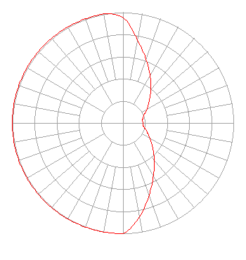 | ||||||||||||||||||
| Azimuth | Ratio | Azimuth | Ratio | Azimuth | Ratio | Azimuth | Ratio | ||||||||||||
| 0 | 0.950 | 10 | 0.760 | 20 | 0.610 | 30 | 0.490 | ||||||||||||
| 40 | 0.390 | 50 | 0.310 | 60 | 0.250 | 70 | 0.200 | ||||||||||||
| 80 | 0.180 | 90 | 0.180 | 100 | 0.190 | 110 | 0.230 | ||||||||||||
| 120 | 0.280 | 130 | 0.350 | 140 | 0.440 | 150 | 0.550 | ||||||||||||
| 160 | 0.690 | 170 | 0.860 | 180 | 1.000 | 190 | 1.000 | ||||||||||||
| 200 | 1.000 | 210 | 1.000 | 220 | 1.000 | 230 | 1.000 | ||||||||||||
| 240 | 1.000 | 250 | 1.000 | 260 | 1.000 | 270 | 1.000 | ||||||||||||
| 280 | 1.000 | 290 | 1.000 | 300 | 1.000 | 310 | 1.000 | ||||||||||||
| 320 | 1.000 | 330 | 1.000 | 340 | 1.000 | 350 | 1.000 | ||||||||||||
Structure Registration Number 1028583 Structure Type: TOWER Registered To: NEBRASKA RURAL RADIO ASSOCIATION DBA = KRVN FM Structure Address: 6.4 Mi S On Hwy 283 E Side Lexington, NE County Name: Gosper County ASR Issued: 09/18/1997 Date Built: 01/01/1982 Site Elevation: 782.4 m (2567 ft.) Structure Height: 97.6 m (320 ft.) Height Overall: 98.8 m (324 ft.) Overall Height AMSL: 881.2 m (2891 ft.) FAA Determination: 08/25/1997 FAA Study #: 97-ACE-1058-OE FAA Circular #: 70/7460-1J Paint & Light FAA Chapters: 3, 4, 5, 13 PREVIOUS STUDY 90-ACE-0920-OE. 40-41-50.0 N 99-47-18.0 W (NAD 83) 40-41-50.0 N 99-47-16.6 W (Converted to NAD 27) |
Po Box 30345 Lincoln, NE 68503 Phone: 402-770-4616 Not-for-Profit | Title: Officer Date: 05/25/2023 Application Certifier Mybridge, Dba As Mybridge Radio Po Box 30345 Lincoln, NE 68503 Applicant Charles Burkhart Sterling Communications, Inc. Po Box 1877 Lafayette, GA 30728 Chief Engineer James E Price, III Sterling Communications, Inc. Po Box 1877 Lafayette, GA 30728 Legal Representative | |||||||||||||||||