
FCCInfo.com
A Service of Cavell, Mertz & Associates, Inc.
(855) FCC-INFO
|
|
|
|
|
||||||||||||||||
|
|
WXRI Channel: 217C2 91.3 MHz Winston-salem, North Carolina Service: FM - A full-service FM station or application. Facility ID: 53100 Fac. Service: FM Status: Construction Permit Application Accepted: 08/16/2023 Application Granted: 10/11/2023 File Number: -0000219466 WXRI CP Expires: 10/11/2026 Application Type: Minor Modification FCC Website Links: LMS Facility Details This Application Other WXRI Applications Other WXRI Applications in CDBS Including Superseded Applications Mailing Address Correspondence for WXRI Correspondence related to application -0000219466 Service Contour - Open Street Map or USGS Map (60 dBu) Service Contour - KML / Google Earth (60 dBu) Public Inspection Files Facility Type: NON-COMMERCIAL EDUC. FM Class: C2, A Zone II station; with 25kW-50kW ERP and a class contour distance 39km-52km Site Location: 36-07-53.1 N 80-30-03.6 W (NAD 83) Site Location: 36-07-52.6 N 80-30-04.4 W (Converted to NAD 27) Effective Radiated Power: 50 kW Antenna Center HAAT: 70 m (230 ft.) Antenna Center AMSL: 320 m (1050 ft.) Antenna Center HAG: 91 m (299 ft.) Site Elevation: 228.6 m. (750 ft.) Height Overall*: 100.6 m (330 ft.) (* As Filed In This Application, may differ from ASR Data, Below.) Directional Antenna Antenna Make/Model: None Antenna ID: 14537 Polarization:
| ||||||||||||||||||
| Antenna Data for Antenna Id: 14537 WXRI FM File: -0000219466 None - Service: FM | 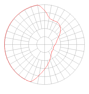 | ||||||||||||||||||
| Azimuth | Ratio | Azimuth | Ratio | Azimuth | Ratio | Azimuth | Ratio | ||||||||||||
| 0 | 0.850 | 10 | 0.680 | 20 | 0.640 | 30 | 0.640 | ||||||||||||
| 40 | 0.600 | 50 | 0.520 | 60 | 0.420 | 70 | 0.340 | ||||||||||||
| 80 | 0.300 | 90 | 0.270 | 100 | 0.240 | 110 | 0.240 | ||||||||||||
| 120 | 0.250 | 130 | 0.250 | 140 | 0.270 | 150 | 0.320 | ||||||||||||
| 160 | 0.400 | 170 | 0.500 | 180 | 0.620 | 190 | 0.780 | ||||||||||||
| 200 | 0.980 | 210 | 1.000 | 220 | 1.000 | 230 | 1.000 | ||||||||||||
| 240 | 1.000 | 250 | 1.000 | 260 | 1.000 | 270 | 1.000 | ||||||||||||
| 280 | 1.000 | 290 | 1.000 | 300 | 1.000 | 310 | 1.000 | ||||||||||||
| 320 | 1.000 | 330 | 1.000 | 340 | 1.000 | 350 | 1.000 | ||||||||||||
Structure Registration Number 1007573 Structure Type: GTOWER Registered To: Positive Radio Group, Inc. of Ohio Structure Address: 362 Bloomtown Rd East Bend, NC County Name: Yadkin County ASR Issued: 08/15/2023 Date Built: 08/15/1996 Site Elevation: 228.6 m (750 ft.) Structure Height: 99 m (325 ft.) Height Overall: 100.6 m (330 ft.) Overall Height AMSL: 329.2 m (1080 ft.) FAA Determination: 08/14/2023 FAA Study #: 2023-ASO-4981-OE FAA Circular #: 70/7460-1M Paint & Light FAA Chapters: 3, 4, 5, 15 PRIOR STUDY 1993-ASO-1003-OE 36-07-53.1 N 80-30-03.6 W (NAD 83) 36-07-52.6 N 80-30-04.4 W (Converted to NAD 27) |
P.o. Box 889 Blacksburg, VA 24063 Phone: 540-552-4281 Not-for-Profit | Title: President Date: 08/16/2023 Application Certifier POSITIVE ALTERNATIVE RADIO, INC. Positive Alternative Radio, Inc. P.o. Box 889 Blacksburg, VA 24063 Applicant Roy P Stype, III Carl E. Smith Consulting Engineers 2324 North Cleveland-massillon Road Bath, OH 44210 Consulting Engineer Cary S. Tepper Tepper Law Firm, Llc 4900 Auburn Avenue Suite 100 Bethesda, MD 20814 Communications Counsel | |||||||||||||||||