
FCCInfo.com
A Service of Cavell, Mertz & Associates, Inc.
(855) FCC-INFO
|
|
W232DG from 08/04/2004 |
|
|
||||||||||||||||
|
|
W232DG Channel: 232D 94.3 MHz Frederick, Maryland Service: FX - A translator or application for a translator. Facility ID: 139260 Fac. Service: FX Programming Delivery Method: Unspecified Status: License Application Accepted: 04/05/2024 Application Granted: 04/18/2024 File Number: -0000243180 License Expires: 10/01/2027 Application Type: License To Cover FCC Website Links: LMS Facility Details This Application Other W232DG Applications Other W232DG Applications in CDBS Including Superseded Applications Mailing Address Correspondence for W232DG Correspondence related to application -0000243180 Service Contour - Open Street Map or USGS Map (60 dBu) Service Contour - KML / Google Earth (60 dBu) Facility Type: FM STATION Class: D, A Noncommercial educational operating with no more than 10W Site Location: 39-29-38.0 N 77-29-55.0 W (NAD 83) Site Location: 39-29-37.6 N 77-29-56.0 W (Converted to NAD 27) Effective Radiated Power: 0.117 kW Transmitter Output Power: 0.056 kW Antenna Center HAAT: 0 m Antenna Center AMSL: 551.7 m (1810 ft.) Antenna Center HAG: 24.4 m (80 ft.) Site Elevation: 527.3 m. (1730 ft.) Height Overall*: 48.7 m (160 ft.) (* As Filed In This Application, may differ from ASR Data, Below.) Directional Antenna Antenna Make/Model: Scala CL-FM-SRM-SV-RR Antenna ID: 1011611 Polarization: H
| ||||||||||||||||||
| Antenna Data for Antenna Id: 1011611 W232DG FX File: -0000243180 Scala - CL-FM-SRM-SV-RR Service: FX | 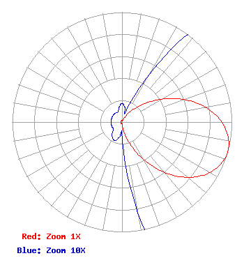 | ||||||||||||||||||
| Azimuth | Ratio | Azimuth | Ratio | Azimuth | Ratio | Azimuth | Ratio | ||||||||||||
| 0 | 0.017 | 10 | 0.014 | 20 | 0.010 | 30 | 0.051 | ||||||||||||
| 40 | 0.133 | 50 | 0.253 | 60 | 0.416 | 70 | 0.601 | ||||||||||||
| 80 | 0.773 | 90 | 0.910 | 100 | 0.985 | 105 | 1.000 | ||||||||||||
| 110 | 0.992 | 120 | 0.922 | 130 | 0.783 | 140 | 0.597 | ||||||||||||
| 150 | 0.392 | 160 | 0.213 | 170 | 0.084 | 180 | 0.014 | ||||||||||||
| 190 | 0.014 | 200 | 0.018 | 210 | 0.017 | 220 | 0.014 | ||||||||||||
| 230 | 0.010 | 240 | 0.010 | 250 | 0.010 | 260 | 0.010 | ||||||||||||
| 270 | 0.010 | 280 | 0.010 | 290 | 0.010 | 300 | 0.010 | ||||||||||||
| 310 | 0.010 | 320 | 0.010 | 330 | 0.010 | 340 | 0.010 | ||||||||||||
| 350 | 0.014 | ||||||||||||||||||
Structure Registration Number 1029055 Structure Type: TOWER Registered To: Business Radio Products Inc. Structure Address: East Side Of Gambrill Park Road Frederick, MD County Name: Frederick County ASR Issued: 10/12/2020 Date Built: 03/05/2003 Site Elevation: 527.3 m (1730 ft.) Structure Height: 48.7 m (160 ft.) Height Overall: 48.7 m (160 ft.) Overall Height AMSL: 576 m (1890 ft.) FAA Determination: 02/05/2003 FAA Study #: 2002-AEA-4022-OE Paint & Light FAA Chapters: NONE 39-29-38.0 N 77-29-55.0 W (NAD 83) 39-29-37.6 N 77-29-56.0 W (Converted to NAD 27) |
880 Commonwealth Ave Hagerstown, MD 21740 Phone: 301-733-4500 Corporation | Title: President Date: 04/05/2024 Application Certifier Manning Broadcasting, Inc. 880 Commonwealth Ave Hagerstown, MD 21740 Applicant Lee G Petro Pillsbury Winthrop Shaw Pittman, Llp 1200 Seventeenth Street Nw Washington, DC 20008 FCC Counsel | |||||||||||||||||