
FCCInfo.com
A Service of Cavell, Mertz & Associates, Inc.
(855) FCC-INFO
|
|
WHVP from 11/15/1991 |
|  |
|
|||||||||||||||
|
|
WHVP Channel: 216A 91.1 MHz Hudson, New York Service: FM - A full-service FM station or application. Facility ID: 60899 Fac. Service: FM Status: License Application Accepted: 05/14/1998 Application Granted: 03/18/2002 File Number: BLED-19980514KB License Expires: 00/00/0000 Prefix Type: This is a license for a noncommercial educational FM station Application Type: License To Cover FCC Website Links: LMS Facility Details This Application CDBS Application Other WHVP Applications Other WHVP Applications in CDBS Including Superseded Applications Mailing Address Correspondence for WHVP Correspondence related to application BLED-19980514KB Service Contour - Open Street Map or USGS Map (60 dBu) Service Contour - KML / Google Earth (60 dBu) Public Inspection Files Facility Type: NON-COMMERCIAL EDUC. FM Class: A, A Zone I; I-A; or II station; with 0.1kW-6kW ERP and a class contour distance <=28km Site Location: 42-18-28.3 N 73-29-33.4 W (NAD 83) Site Location: 42-18-28.0 N 73-29-35.0 W (Converted to NAD 27) Effective Radiated Power: 0 kW Horiz. ; 0.22 kW Vert. Transmitter Output Power: 0.3 kW Antenna Center HAAT: 0 m Horiz.; 318 m Vert. Antenna Center AMSL: 0 m Horiz.; 623 m Vert. Antenna Center HAG: 0 m Horiz.; 99 m Vert. Site Elevation: 524 m. (1719 ft.) Height Overall*: 100 m (328 ft.) (* As Filed In This Application, may differ from ASR Data, Below.) Directional Antenna Antenna Make/Model: Scala FMV-1 Antenna ID: 15348 Polarization: | ||||||||||||||||||
| Antenna Data for Antenna Id: 15348 WHVP FM File: BLED-19980514KB Scala - FMV-1 Service: FM Pattern and Field Values Include a 135° Clockwise Rotation | 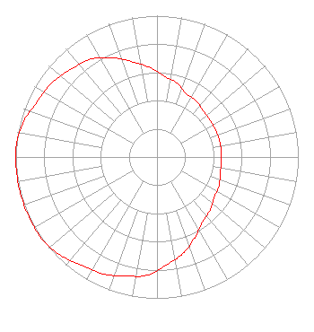 | ||||||||||||||||||
| Azimuth | Ratio | Azimuth | Ratio | Azimuth | Ratio | Azimuth | Ratio | ||||||||||||
| 5 | 0.575 | 15 | 0.543 | 25 | 0.495 | 35 | 0.484 | ||||||||||||
| 45 | 0.463 | 55 | 0.457 | 65 | 0.457 | 75 | 0.457 | ||||||||||||
| 85 | 0.457 | 95 | 0.457 | 105 | 0.463 | 115 | 0.484 | ||||||||||||
| 125 | 0.495 | 135 | 0.531 | 145 | 0.562 | 155 | 0.631 | ||||||||||||
| 165 | 0.708 | 175 | 0.767 | 185 | 0.841 | 195 | 0.871 | ||||||||||||
| 205 | 0.912 | 215 | 0.933 | 225 | 0.977 | 235 | 1.000 | ||||||||||||
| 245 | 1.000 | 255 | 1.000 | 265 | 1.000 | 275 | 1.000 | ||||||||||||
| 285 | 0.977 | 295 | 0.933 | 305 | 0.912 | 315 | 0.871 | ||||||||||||
| 325 | 0.841 | 335 | 0.776 | 345 | 0.700 | 355 | 0.638 | ||||||||||||
Structure Registration Number 1041107 [ASR Heights Differ from WHVP Application] Structure Type: GTOWER Registered To: Pinnacle Towers LLC Structure Address: W Hill Rd Austerlitz, NY County Name: Columbia County ASR Issued: 05/06/2016 Date Built: 03/02/1998 Site Elevation: 512.1 m (1680 ft.) Structure Height: 91.4 m (300 ft.) Height Overall: 95.1 m (312 ft.) Overall Height AMSL: 607.2 m (1992 ft.) FAA Determination: 02/11/2016 FAA Study #: 2016-AEA-463-OE FAA Circular #: 70/7460-1K Paint & Light FAA Chapters: 4, 6, 12 OM&L to remain the same as prior study = 24-HR MED-STROBES 42-18-21.8 N 73-29-27.1 W (NAD 83) 42-18-21.5 N 73-29-28.7 W (Converted to NAD 27) |
Po Box 777 199 Tuytenbridge Rd Lake Katrine, NY 12449-0777 | Date: 05/14/1998 Application Certifier SOUND OF LIFE, INC. Sound Of Life, Inc. P.o. Box 777 Lake Katrine, NY 12449 Applicant | |||||||||||||||||