
FCCInfo.com
A Service of Cavell, Mertz & Associates, Inc.
(855) FCC-INFO
|
|
|
|
|
||||||||||||||||
|
|
W274CE Channel: 274D 102.7 MHz Greenville, Illinois Service: FX - A translator or application for a translator. Facility ID: 200258 Fac. Service: FX Programming Delivery Method: Unspecified Status: License Application Accepted: 09/12/2018 Application Granted: 10/01/2018 File Number: BLFT-20180912AAI License Expires: 00/00/0000 Prefix Type: This is a license for a translator Application Type: License To Cover FCC Website Links: LMS Facility Details This Application CDBS Application Other W274CE Applications Other W274CE Applications in CDBS Including Superseded Applications Mailing Address Correspondence for W274CE Correspondence related to application BLFT-20180912AAI Service Contour - Open Street Map or USGS Map (60 dBu) Service Contour - KML / Google Earth (60 dBu) Class: D, A Noncommercial educational operating with no more than 10W Site Location: 38-51-51.2 N 89-26-18.3 W (NAD 83) Site Location: 38-51-51.0 N 89-26-18.0 W (Converted to NAD 27) Effective Radiated Power: 0.25 kW Transmitter Output Power: 0.495 kW Antenna Center HAAT: 0 m Antenna Center AMSL: 257 m (843 ft.) Antenna Center HAG: 86 m (282 ft.) Site Elevation: 171 m. (561 ft.) Height Overall*: 97 m (318 ft.) (* As Filed In This Application, may differ from ASR Data, Below.) Directional Antenna Antenna Make/Model: None Antenna ID: 132159 Polarization:
| ||||||||||||||||||
| Antenna Data for Antenna Id: 132159 W274CE FX File: BLFT-20180912AAI None - Service: FX | 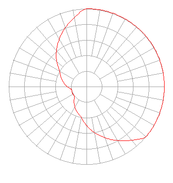 | ||||||||||||||||||
| Azimuth | Ratio | Azimuth | Ratio | Azimuth | Ratio | Azimuth | Ratio | ||||||||||||
| 0 | 1.000 | 10 | 1.000 | 20 | 1.000 | 30 | 1.000 | ||||||||||||
| 40 | 1.000 | 50 | 1.000 | 60 | 1.000 | 70 | 1.000 | ||||||||||||
| 80 | 1.000 | 90 | 1.000 | 100 | 1.000 | 110 | 1.000 | ||||||||||||
| 120 | 1.000 | 130 | 1.000 | 140 | 0.900 | 150 | 0.800 | ||||||||||||
| 160 | 0.700 | 170 | 0.600 | 180 | 0.500 | 190 | 0.400 | ||||||||||||
| 200 | 0.350 | 210 | 0.300 | 220 | 0.250 | 230 | 0.200 | ||||||||||||
| 240 | 0.200 | 250 | 0.200 | 260 | 0.200 | 270 | 0.250 | ||||||||||||
| 280 | 0.300 | 290 | 0.350 | 300 | 0.400 | 310 | 0.500 | ||||||||||||
| 320 | 0.600 | 330 | 0.700 | 340 | 0.800 | 350 | 0.900 | ||||||||||||
Structure Registration Number 1210973 Structure Type: TOWER Registered To: SpectraSite Communications, LLC. through American Towers, LLC. Structure Address: West Old National Trail(303830) Greenville, IL County Name: Bond County ASR Issued: 01/16/2013 Date Built: 06/09/2000 Site Elevation: 171.3 m (562 ft.) Structure Height: 91.7 m (301 ft.) Height Overall: 96.6 m (317 ft.) Overall Height AMSL: 267.9 m (879 ft.) FAA Determination: 03/03/2009 FAA Study #: 2008-AGL-7280-OE FAA Circular #: 70/7460-1J Paint & Light FAA Chapters: 4, 8, 13 OM&L to remain the same as prior study = A MED-DUAL SYSTEM 38-51-50.7 N 89-26-18.1 W (NAD 83) 38-51-50.5 N 89-26-17.8 W (Converted to NAD 27) |
P.o. Box 150846 Nashville, TN 37215-0846 Phone: 615-361-7560 | Date: 09/12/2018 Application Certifier THE CROMWELL GROUP, INC. OF ILLINOIS P.o. Box 150846 Nashville, TN 37215-0846 Applicant CHARLES M. ANDERSON 1519 Euclid Avenue Bowling Green, KY 42103 BROADCAST CONSULTANT JOHN F. GARZIGLIA, ESQ. Womble Bond Dickinson (us) Llp 1200 19th Street, N.w., Suite 500 Washington, DC 20036 | |||||||||||||||||