
FCCInfo.com
A Service of Cavell, Mertz & Associates, Inc.
(855) FCC-INFO
|
|
|
|  |
|
|||||||||||||||
|
|
WLKM-FM Channel: 240A 95.9 MHz Three Rivers, Michigan Service: FM - A full-service FM station or application. Facility ID: 70461 Fac. Service: FM Status: License Application Accepted: 10/06/2009 Application Granted: 10/15/2009 File Number: BLH-20091006ABF License Expires: 00/00/0000 Prefix Type: This is a license for a commercial FM station Application Type: License To Cover FCC Website Links: LMS Facility Details This Application CDBS Application Other WLKM-FM Applications Other WLKM-FM Applications in CDBS Including Superseded Applications Mailing Address Correspondence for WLKM-FM Correspondence related to application BLH-20091006ABF Service Contour - Open Street Map or USGS Map (60 dBu) Service Contour - KML / Google Earth (60 dBu) Public Inspection Files History Cards for WLKM-FM Facility Type: FM STATION Class: A, A Zone I; I-A; or II station; with 0.1kW-6kW ERP and a class contour distance <=28km Site Location: 41-53-51.2 N 85-33-51.0 W (NAD 83) Site Location: 41-53-51.0 N 85-33-51.0 W (Converted to NAD 27) Effective Radiated Power: 3.6 kW Transmitter Output Power: 1.87 kW Antenna Center HAAT: 129.6 m (425 ft.) Antenna Center AMSL: 382.5 m (1255 ft.) Antenna Center HAG: 123.4 m (405 ft.) Calculated Site Elevation: 259.1 m. (850 ft.) Height Overall*: 128.9 m (423 ft.) (* As Filed In This Application, may differ from ASR Data, Below.) Directional Antenna Antenna Make/Model: Propagation System Inc PSIFM-3-DA Antenna ID: 89938 Polarization: | ||||||||||||||||||
| Antenna Data for Antenna Id: 89938 WLKM-FM FM File: BLH-20091006ABF Propagation System Inc - PSIFM-3-DA Service: FM | 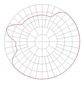 | ||||||||||||||||||
| Azimuth | Ratio | Azimuth | Ratio | Azimuth | Ratio | Azimuth | Ratio | ||||||||||||
| 0 | 0.707 | 10 | 0.707 | 20 | 0.707 | 30 | 0.890 | ||||||||||||
| 40 | 1.000 | 50 | 1.000 | 60 | 1.000 | 70 | 1.000 | ||||||||||||
| 80 | 1.000 | 90 | 1.000 | 100 | 1.000 | 110 | 1.000 | ||||||||||||
| 120 | 1.000 | 130 | 1.000 | 140 | 1.000 | 150 | 1.000 | ||||||||||||
| 160 | 1.000 | 170 | 1.000 | 180 | 1.000 | 190 | 1.000 | ||||||||||||
| 200 | 1.000 | 210 | 1.000 | 220 | 1.000 | 230 | 1.000 | ||||||||||||
| 240 | 0.890 | 250 | 0.707 | 260 | 0.707 | 270 | 0.707 | ||||||||||||
| 280 | 0.890 | 290 | 1.000 | 300 | 0.890 | 310 | 0.707 | ||||||||||||
| 320 | 0.707 | 330 | 0.707 | 340 | 0.707 | 350 | 0.707 | ||||||||||||
Structure Registration Number 1267803 Structure Type: TOWER Registered To: Impact Radio, LLC Structure Address: North Side Of Fairchild Road, 0.1 Mi East Of Engle Road Centreville, MI County Name: St. Joseph County ASR Issued: 04/02/2009 Date Built: 09/25/2009 Site Elevation: 259.1 m (850 ft.) Structure Height: 128 m (420 ft.) Height Overall: 128.9 m (423 ft.) Overall Height AMSL: 388 m (1273 ft.) FAA Determination: 03/30/2009 FAA Study #: 2009-AGL-1360-OE FAA Circular #: 70/7460-1K Paint & Light FAA Chapters: 4, 6, 12 PRIOR STUDY 2008-AGL-2431-OE 41-53-50.8 N 85-33-50.6 W (NAD 83) 41-53-50.6 N 85-33-50.6 W (Converted to NAD 27) |
59750 Constantine Road Three Rivers, MI 49093 Phone: 269-278-1815 Limited Liability Company | Date: 10/06/2009 Application Certifier IMPACT RADIO, LLC 59750 Constantine Road Three Rivers, MI 49093 Applicant WALKER SISSON 2507 University Ave. Kalamazoo, MI 49008 TECHNICAL CONSULTANT MATTHEW H. MCCORMICK Fletcher, Heald & Hildreth, P.l.c. | |||||||||||||||||